 |
Sea Surface Temperature and Sea Level From Eastern Pacific
GOES Stations
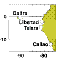
David B. EnField, NOAA/AOML
Instituto Oceanografico de la Armada Guayaquil, Ecuador
Direccion de Hodrografia y Navigacion de la Marina, Callao, PERU
JULY 2008
|
Through
cooperative arrangements with South American institutions, the TOGA
program has maintained a network of nine tide stations and four
meteorological stations in Ecuador, Peru and Chile since the mid
1980's. The stations are maintained by NOAA/AOML and the University of
Hawaii. The hourly data are transmitted to down-link stations via the
GOES satellite in real time and processed. The five-day averages
(pentads) at critical stations give us an effective means of monitoring
coastal conditions with good time resolution and compact data volume.
|
|
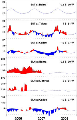
The main points of interest regarding July are (1) that
the positive SST anomalies -- heretofore seen at Talara
in recent months, have now appeared at Callao, and (2)
that positive sea level anomalies at Callao have persisted
for more than two months and now exceed the typical time
scale of intraseasonal Kelvin wave surges.
|
| |
|
Day of   Sea Sfc Temperature    Sea Level Height (cm)
 Jul     Baltra Talara Callao   Baltra Libertad Callao
------   ------ ------ ------   ------  ------  ------
   2       **    19.5   17.6       **      **    112.5
   7       **    19.6   17.5       **      **    122.4
  12       **    19.8   17.5       **      **    114.2
  17       **    20.0   17.6       **      **    119.3
  22       **    20.3   17.5       **      **    116.0
  27       **    20.1   17.7       **      **    113.6

                       Anomalies
   2       **     1.4    1.2       **      **      1.5
   7       **     1.6    1.2       **      **     11.7
  12       **     2.0    1.2       **      **      3.8
  17       **     2.3    1.4       **      **      9.2
  22       **     2.6    1.4       **      **      6.4
  27       **     2.4    1.6       **      **      4.4

For further information contact David.Enfield@noaa.gov
 or go to http://www.aoml.noaa.gov/phod/epac/
** - Data missing due to hardware failure
|
FIGURE A1.5
Five-day averages of Sea Surface
Temperature (SST, C) and Sea Level Height (SLH, cm) from GOES receiving
stations in Ecuador and Peru. Dashed line and shading show climatology
departures.
|
 |


