 |
Sea Surface Temperature and Sea Level From Eastern Pacific
GOES Stations
David B. EnField, NOAA/AOML
Instituto Oceanografico de la Armada Guayaquil, Ecuador
Direccion de Hodrografia y Navigacion de la Marina, Callao, PERU
NOVEMBER 2010
|
Through
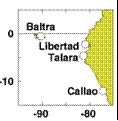
cooperative arrangements with South American institutions, the TOGA
program has maintained a network of nine tide stations and four
meteorological stations in Ecuador, Peru and Chile since the mid
1980's. The stations are maintained by NOAA/AOML and the University of
Hawaii. The hourly data are transmitted to down-link stations via the
GOES satellite in real time and processed. The five-day averages
(pentads) at critical stations give us an effective means of monitoring
coastal conditions with good time resolution and compact data volume.
|
|
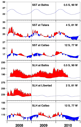
The first half of November saw the most intense anomalies
yet in this very strong La Niña event, with SSTs 3C below
normal and sea levels almost 10 cm below normal. There
was a sudden uptick (decrease in the negative anomalies)
in the latter half of the month. We don't know whether
this is the beginning of the end of the event, or simply
the first in a series of intraseasonal oscillations that
we typically see during the boreal winter and spring.
|
| |
|
Day of   Sea Sfc Temperature    Sea Level Height (cm)
 Nov     Baltra Talara Callao   Baltra Libertad Callao
------   ------ ------ ------   ------  ------  ------
   4       **    14.8   13.9       **      **     97.8
   9       **    15.4   13.9       **      **     94.1
  14       **    15.9   13.7       **      **     95.4
  19       **    16.4   13.8       **      **     99.4
  24       **    17.5   14.7       **      **    100.0
  29       **    17.0   14.1       **      **    101.3

                       Anomalies
   4       **    -3.2   -1.6       **      **     -8.9
   9       **    -2.7   -1.7       **      **    -12.8
  14       **    -2.2   -2.0       **      **    -11.8
  19       **    -1.8   -2.0       **      **     -8.1
  24       **    -0.8   -1.1       **      **     -7.8
  29       **    -1.4   -1.8       **      **     -6.8

For further information contact David.Enfield@noaa.gov
 or go to http://www.aoml.noaa.gov/phod/epac/
  ** - Data missing due to hardware failure
|
FIGURE A1.5
Five-day averages of Sea Surface
Temperature (SST, C) and Sea Level Height (SLH, cm) from GOES receiving
stations in Ecuador and Peru. Dashed line and shading show climatology
departures.
|
 |


