 |
Sea Surface Temperature and Sea Level From Eastern Pacific
GOES Stations
David B. EnField, NOAA/AOML
Instituto Oceanografico de la Armada Guayaquil, Ecuador
Direccion de Hodrografia y Navigacion de la Marina, Callao, PERU
SEPTEMBER 2010
|
Through
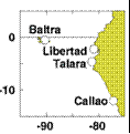
cooperative arrangements with South American institutions, the TOGA
program has maintained a network of nine tide stations and four
meteorological stations in Ecuador, Peru and Chile since the mid
1980's. The stations are maintained by NOAA/AOML and the University of
Hawaii. The hourly data are transmitted to down-link stations via the
GOES satellite in real time and processed. The five-day averages
(pentads) at critical stations give us an effective means of monitoring
coastal conditions with good time resolution and compact data volume.
|
|
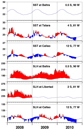
The negative SST and sea level anomalies have continued
unabated for the last 4-5 months. Negative SST anomalies
intensified in September close to the equator, suggesting
that the centroid of equatorial La Niña anomalies is encroaching
toward the coast, expanding, or intensifying everywhere.
|
| |
|
Day of   Sea Sfc Temperature    Sea Level Height (cm)
 Sep     Baltra Talara Callao   Baltra Libertad Callao
------   ------ ------ ------   ------  ------  ------
   5       **    15.3   14.5       **      **     93.9
  10       **    15.8   13.9       **      **     99.6
  15       **    15.1   14.2       **      **     93.1
  20       **    14.7   14.1       **      **     95.0
  25       **    16.5   14.1       **      **     94.5
  30       **    15.6   14.1       **      **     91.8

                       Anomalies
   5       **    -2.5   -1.0       **      **    -12.4
  10       **    -2.0   -1.6       **      **     -6.4
  15       **    -2.8   -1.2       **      **    -12.8
  20       **    -3.2   -1.3       **      **    -10.9
  25       **    -1.4   -1.2       **      **    -11.3
  30       **    -2.3   -1.2       **      **    -13.9

For further information contact David.Enfield@noaa.gov
 or go to http://www.aoml.noaa.gov/phod/epac/
  ** - Data missing due to hardware failure
|
FIGURE A1.5
Five-day averages of Sea Surface
Temperature (SST, C) and Sea Level Height (SLH, cm) from GOES receiving
stations in Ecuador and Peru. Dashed line and shading show climatology
departures.
|
 |


