 |
Sea Surface Temperature and Sea Level From Eastern Pacific
GOES Stations
David B. EnField, NOAA/AOML
Instituto Oceanografico de la Armada Guayaquil, Ecuador
Direccion de Hodrografia y Navigacion de la Marina, Callao, PERU
JUNE 2009
|
Through
cooperative arrangements with South American institutions, the TOGA
program has maintained a network of nine tide stations and four
meteorological stations in Ecuador, Peru and Chile since the mid
1980's. The stations are maintained by NOAA/AOML and the University of
Hawaii. The hourly data are transmitted to down-link stations via the
GOES satellite in real time and processed. The five-day averages
(pentads) at critical stations give us an effective means of monitoring
coastal conditions with good time resolution and compact data volume.
|
|
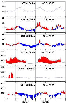
As evidenced by the Callao sea levels, a sharp transition
to persistent high sea level took place in April, and now
the SST is beginning to rise, lagged as we would expect.
This is consistent with indications from large scale patterns
that a period of persistent warm anomalies is beginning in
the eastern Pacific.
|
| |
|
Day of   Sea Sfc Temperature    Sea Level Height (cm)
 Jun     Baltra Talara Callao   Baltra Libertad Callao
------   ------ ------ ------   ------  ------  ------
   2       **    19.0   16.8       **      **    113.3
   7       **    18.9   16.2       **      **    115.3
  12       **    18.9   16.9       **      **    118.1
  17       **    19.5   16.8       **      **    120.9
  22       **    18.5   17.3       **      **    120.2
  27       **    18.3   17.8       **      **    121.2

                       Anomalies
   2       **     0.1   -0.1       **      **      0.7
   7       **     0.1   -0.6       **      **      2.9
  12       **     0.1    0.2       **      **      5.9
  17       **     0.9    0.2       **      **      8.9
  22       **     0.0    0.8       **      **      8.5
  27       **     0.0    1.4       **      **      9.9

For further information contact David.Enfield@noaa.gov
 or go to http://www.aoml.noaa.gov/phod/epac/
** - Data missing due to hardware failure
|
FIGURE A1.5
Five-day averages of Sea Surface
Temperature (SST, C) and Sea Level Height (SLH, cm) from GOES receiving
stations in Ecuador and Peru. Dashed line and shading show climatology
departures.
|
 |


