 |
Sea Surface Temperature and Sea Level From Eastern Pacific
GOES Stations
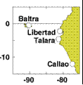
David B. EnField, NOAA/AOML
Instituto Oceanografico de la Armada Guayaquil, Ecuador
Direccion de Hodrografia y Navigacion de la Marina, Callao, PERU
MAY 2010
|
Through
cooperative arrangements with South American institutions, the TOGA
program has maintained a network of nine tide stations and four
meteorological stations in Ecuador, Peru and Chile since the mid
1980's. The stations are maintained by NOAA/AOML and the University of
Hawaii. The hourly data are transmitted to down-link stations via the
GOES satellite in real time and processed. The five-day averages
(pentads) at critical stations give us an effective means of monitoring
coastal conditions with good time resolution and compact data volume.
|
|
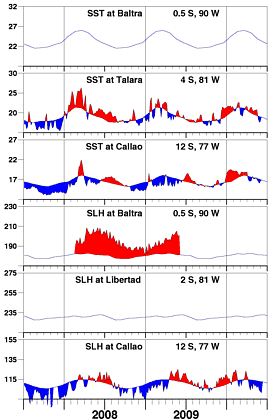
SSTs and sea level continue to oscillate about normal
values, although with a tendency toward seasonally
lower sea level farther south (Callao). The amplitude
of intraseasonal oscillations compared with the first
half of previous years, appears weaker. We will want
to be alert for signs of persistent and growing negative
anomalies in both variables, which could possibly confirm
other indications (e.g., along the equator) of a developing
La Niña condition over the rest of 2010.
|
| |
|
Day of   Sea Sfc Temperature    Sea Level Height (cm)
 May     Baltra Talara Callao   Baltra Libertad Callao
------   ------ ------ ------   ------  ------  ------
   3       **    20.6   17.1       **      **    109.0
   8       **    20.7   17.5       **      **    106.7
  13       **    20.8   17.0       **      **    108.4
  18       **    18.6   16.6       **      **    103.7
  23       **    17.6   16.0       **      **    102.7
  28       **    17.8   16.5       **      **    101.4

                       Anomalies
   3       **     1.1   -0.3       **      **     -4.6
   8       **     1.3    0.2       **      **     -6.8
  13       **     1.5   -0.2       **      **     -4.9
  18       **    -0.6   -0.6       **      **     -9.4
  23       **    -1.5   -1.1       **      **    -10.1
  28       **    -1.2   -0.5       **      **    -11.2

For further information contact David.Enfield@noaa.gov
 or go to http://www.aoml.noaa.gov/phod/epac/
  ** - Data missing due to hardware failure
|
FIGURE A1.5
Five-day averages of Sea Surface
Temperature (SST, C) and Sea Level Height (SLH, cm) from GOES receiving
stations in Ecuador and Peru. Dashed line and shading show climatology
departures.
|
 |


