 |
Sea Surface Temperature and Sea Level From Eastern Pacific
GOES Stations
David B. EnField, NOAA/AOML
Instituto Oceanografico de la Armada Guayaquil, Ecuador
Direccion de Hodrografia y Navigacion de la Marina, Callao, PERU
FEBRUARY 2008
|
Through
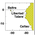
cooperative arrangements with South American institutions, the TOGA
program has maintained a network of nine tide stations and four
meteorological stations in Ecuador, Peru and Chile since the mid
1980's. The stations are maintained by NOAA/AOML and the University of
Hawaii. The hourly data are transmitted to down-link stations via the
GOES satellite in real time and processed. The five-day averages
(pentads) at critical stations give us an effective means of monitoring
coastal conditions with good time resolution and compact data volume.
|
|
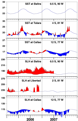
Thanks to another intraseasonal Kelvin wave pulse arriving
at the end of February, coastal SSTs and sea levels are once
again rising from negative anomalies toward normal along the
Peru coast. With warmer water upwelling near the coast, cooler
water still offshore, and the onshore winds typical of the
rainy season, Ecuador can probably expect continued unstable
atmospheric conditions through March.
|
| |
|
Day of   Sea Sfc Temperature    Sea Level Height (cm)
 Feb     Baltra Talara Callao   Baltra Libertad Callao
------   ------ ------ ------   ------  ------  ------
   2       **    25.4   15.6       **      **    104.1
   7       **    24.5   15.6       **      **    103.2
  12       **    22.1   15.6       **      **    103.7
  17       **    21.7   16.3       **      **    106.0
  22       **    24.0   16.4       **      **    111.8
  27       **    25.6   17.8       **      **      **

                       Anomalies
   2       **     4.6   -1.4       **      **     -9.0
   7       **     3.4   -1.5       **      **    -10.3
  12       **     0.8   -1.7       **      **    -10.2
  17       **     0.3   -1.2       **      **     -8.1
  22       **     2.7   -1.2       **      **     -2.4
  27       **     4.3   -0.1       **      **      **

For further information contact David.Enfield@noaa.gov
 or go to http://www.aoml.noaa.gov/phod/epac/
 ** - Data missing due to hardware failure
|
FIGURE A1.5
Five-day averages of Sea Surface
Temperature (SST, C) and Sea Level Height (SLH, cm) from GOES receiving
stations in Ecuador and Peru. Dashed line and shading show climatology
departures.
|
 |


