Long-lead Forecast Tool Discussion and Analysis
Forecast Tools:
CFS - An ensemble mean forecast from a fully-coupled - one-tier ocean-atmosphere dynamical model with no ocean-atmosphere flux adjustments done in post-processing. Ocean initial conditions are from the global ocean data assimilation system (GODAS). Forecasters use an ensemble mean of 40 forecast members. All anomalies are with respect to a 1982-2003 hindcast climatology - except for Niño SSTs - for which a bias correction with the 1982-2003 average is first applied. The observed Niño climatology for 1981-2010 is then used to define the Niño anomalies.
NMME - The North American Multi-Model Ensemble (NMME) is a multi-model seasonal forecasting system consisting of fully coupled global models from multiple modeling centers in the U.S. and Canada. The model suite will occasionally change as individual models are updated or replaced; the suite has featured between 6 and 8 models since inception in August 2011. The seasonal (three-month) nmme forecasts are available from 1- to 5-month leads; monthly mean forecasts are available from 1- to 7-month leads. Available forecasts from this system include individual model ensemble mean anomalies, the multi-model ensemble mean anomaly, and probabilistic forecasts based on all ensemble members from all models (usually approximately 100 ensemble members total). Anomaly forecasts are corrected for bias in the individual models' mean climatologies; probabilistic forecasts are corrected for bias in the individual models' mean and standard deviation. A calibrated version of the probabilistic forecasts is created using the probability anomaly correlation calibration method (van den dool et al. 2016). The NMME is updated monthly on the 7th day of the month.
CCA - Canonical Correlation Analysis linearly predicts the evolution of patterns of temperature and precipitation based upon patterns of global SST - 700mb height - and U.S. surface temperature and precipitation from the past year for the most recent four non-overlapping seasons. CCA emphasizes ENSO effects - but only in a linear way - and can also account for trends - low frequency atmospheric modes such as the north atlantic oscillation (NAO) and other lagged teleconnections in the ocean-atmosphere system. CCA forecasts are available for all 13 forecast periods for the lower 48 states - Hawaii - and Alaska.
ECCA - Utilizes the CCA (Canonical Correlation Analysis) method of projecting loading patterns onto predictor fields to make a linear prediction of temperature and precipitation. These loading patterns are statistically determined by maximizing the correlation between the predictors and predictands (forecast fields) using data going back to 1953. The ensemble is created by making forecasts using various predictor variables to make forecasts, then averaging the forecasts with equal weights. The pool of possible predictors used are 200mb global velocity potential, global sea surface temperatures, sea level pressure (north of 40° N), and us soil moisture. ENSO COMPOSITES - Averages of observational data stratified by El Niño - La Niña or ENSO-neutral conditions provide guidance for U.S. El Niño and La Niña effects by supplying historical frequencies of the three forecast classes in past years when (for the particular forecast season) the central equatorial pacific was characterized by moderate or strong La Niña or El Niño conditions. Regions influenced by ENSO are defined by historical frequencies that differ significantly from climatology. Probability anomalies are estimated by the use of historical frequencies tempered by the degree of confidence that either warm or cold ENSO conditions will be in place in a given target season. Versions of the maps of the historical frequencies used to make the forecasts can be viewed under "U.S. El Niño/La Niña impacts" on the CPC website located at - https://www.cpc.ncep.noaa.gov/products/precip/CWlink/MJO/enso.shtml#composite.
OCN - The optimal climate normals method predicts t and p on the basis of year-to-year persistence of the observed average anomalies for a given season during the last 10 years for t - and the last 15 years for p. OCN emphasizes long-term trends and multi-year regime effects. OCN forecasts are available for all 13 forecast periods - but are not yet available for Hawaii.
CAS - Constructed analog on soil moisture is based on empirical orthogonal functions (EOF) from data over the lower 48 states beginning in 1932. This tool constructs a soil moisture analog from a weighted mean of past years. The weights are determined from the similarity of soil moisture conditions in prior years to a combination of recently soil moisture observations and a medium range forecast of soil moisture out to 14 days based on MRF temperature and precipitation forecasts. Then the temperature and precipitation observed in subsequent seasons in those past years are weighted in the same proportion to produce a forecast that is consistent with current soil moisture conditions. Although available throughout the year - the CAS is used only during the warm half of the year from April to September and for the shorter leads when their effects are the most pronounced and skillful.
SMLR - Screening Multiple Linear Regression tool is used to extract information from a variety of sources to produce a forecast for seasonal and monthly temperature and precipitation. SMLR uses the same predictor fields as for CCA but is applied to single stations rather than multi-station anomaly patterns as is done in CCA. Additionally - SMLR uses the two week mrf-based soil moisture forecast as a predictor.
Forecast Skill:
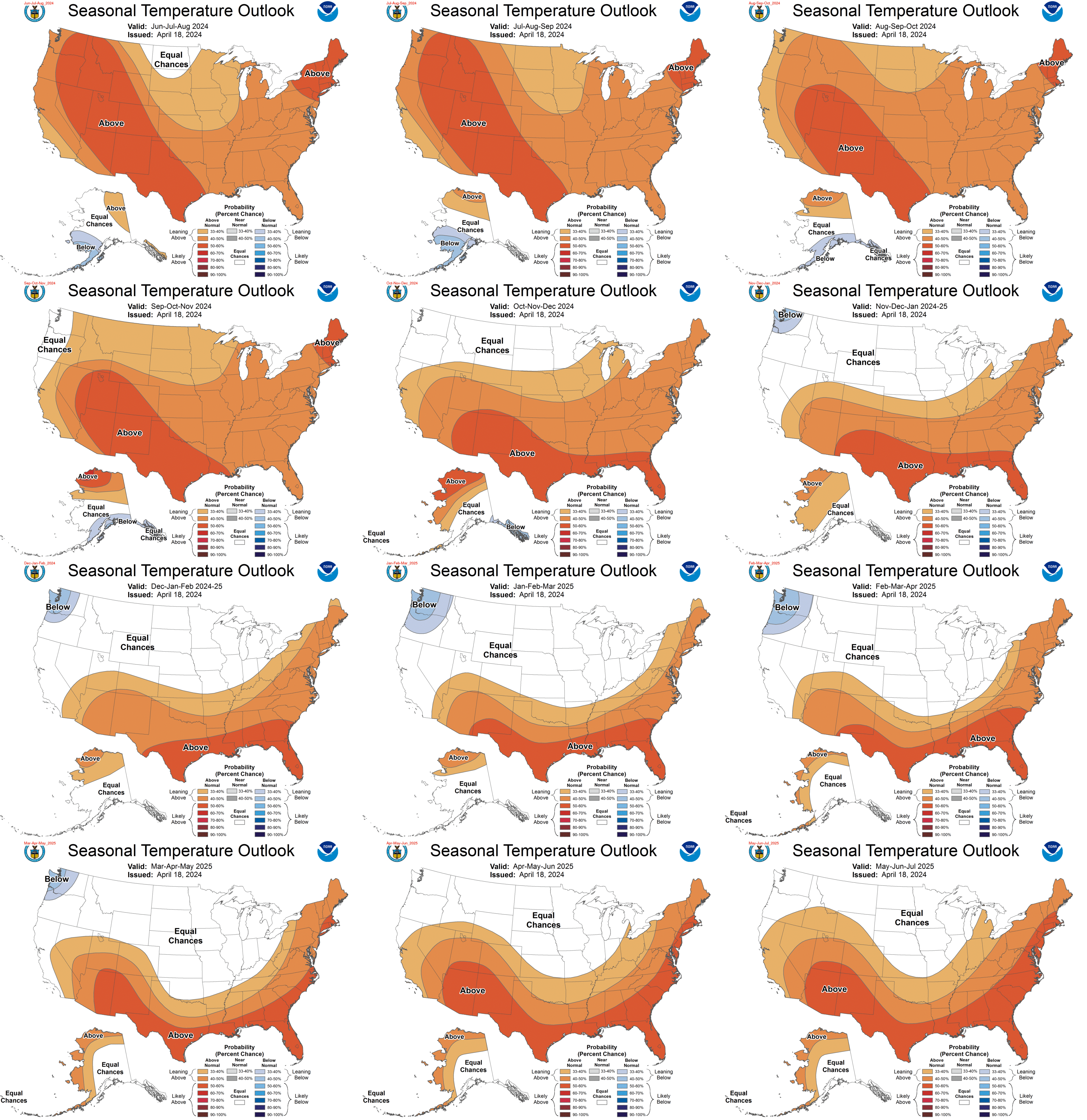
Predictive accuracy in the lower 48 states for temperature peaks in the late winter with a secondary peak in the late summer - and is lowest in the late spring and late fall. Alaskan temperature skill is highest in the early winter and also good in early summer and is lowest in early fall for CCA.
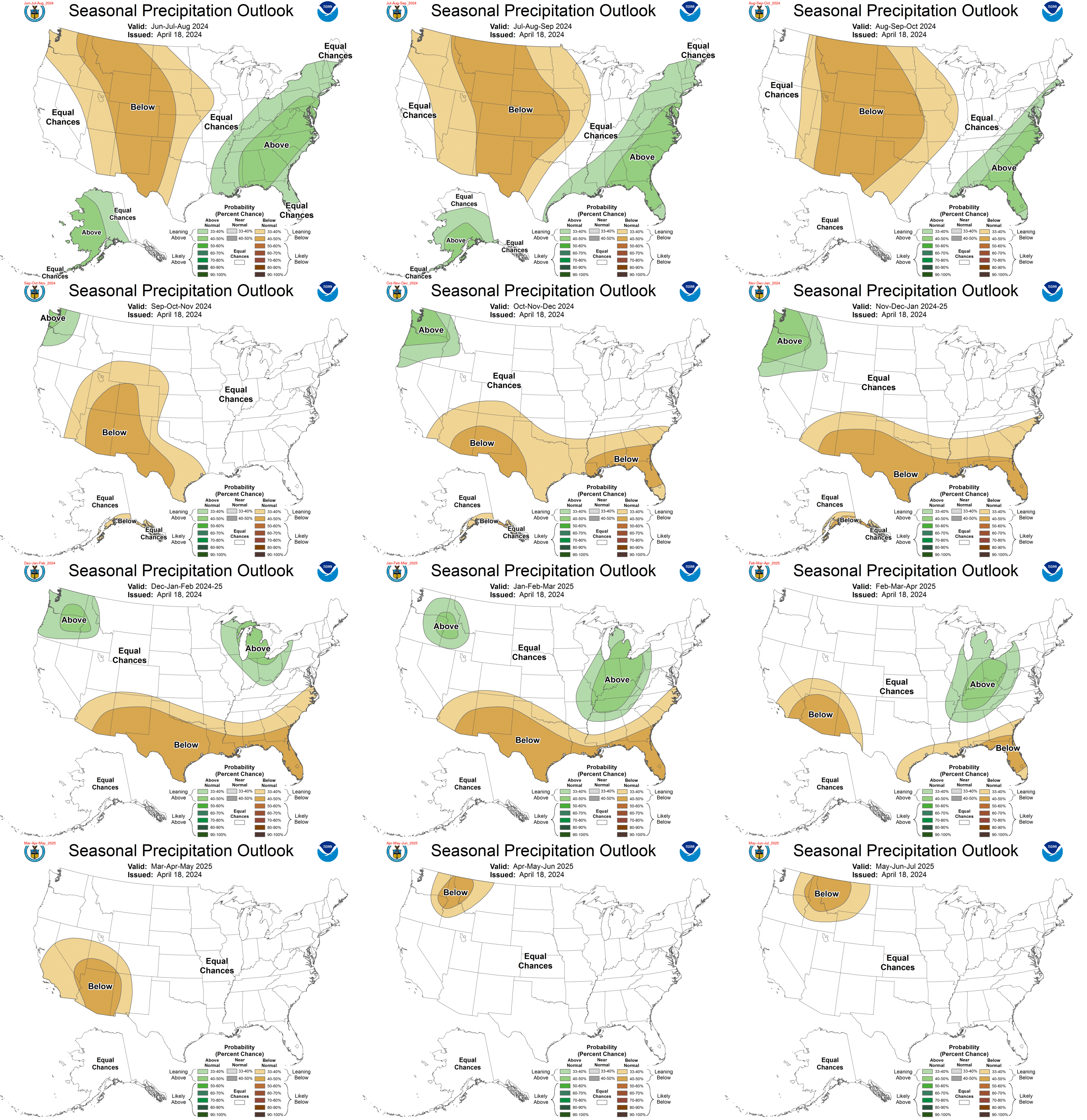
For all models precipitation forecasts are generally less skillful than temperature -- with marginal skill for all tools even in their best seasons and locations under normal circumstances. However when strong El Niño or La Niña conditions are present - precipitation skill can be as high as temperature skill for cool season forecasts for a number of areas of the U.S. - including the southern third - the northern rockies - the high plains and the Ohio valley. Strong la Niña conditions imply the possibility of moderate precipitation skill for some parts of the warm season as well.
24 years of hindcasts are run each month for use in defining the climatology and skill characteristics of the CFS. A skill mask is constructed from this data and masked forecasts are provided to the forecaster.
Skill of CFS Niño 3.4 forecasts equals or exceeds that of the statistical forecast models at leads out to nine months.
The Constructed Analog Forecast from soil moisture (CAS) gives highest skill for temperature from April through September - with peak skill in early summer. The most skillful seasons for precipitation forecasts are SON through JFM for OCN predictions - and the late winter for the other tools. Alaskan skill peaks in the late fall for both CCA and the CMP.
The Screening Multiple Linear Regression (SMLR) tool has skill characteristics somewhat similar to CCA - but since it is designed to predict for individual stations and regional climate divisions it may do better than CCA in smaller regions having unique relationships such as those caused by local terrain - adjacent water bodies - or developing urban heat islands.
Forecast Format:
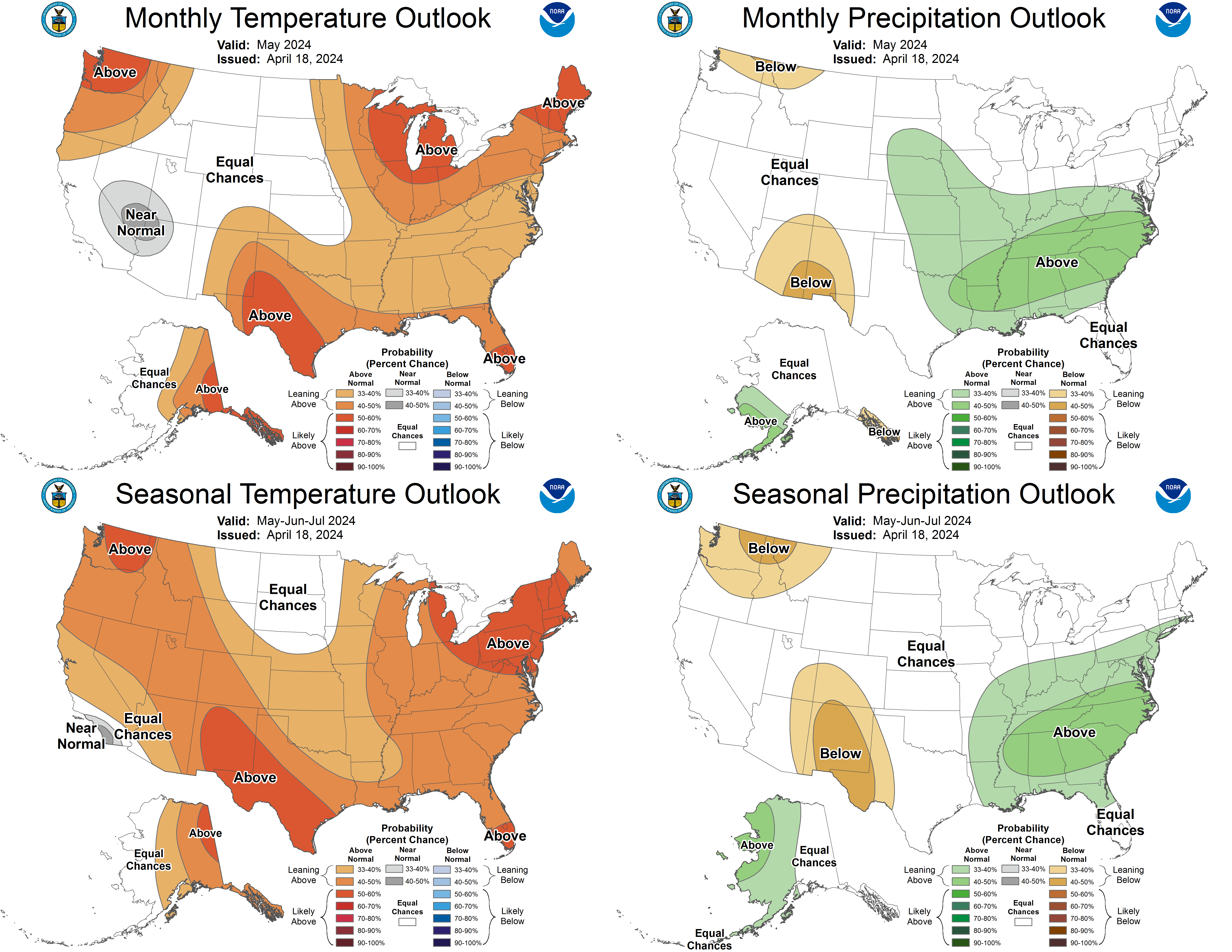
Forecasts are expressed as the probabilities of the observation of mean temperature (total precipitation) falling into the most likely of three classes - either above - near - or below normal (median). Classes are defined by limits that divide the 1981-2010 climatological distribution into thirds. Thus each class has a climatological chance of occurance of 33.3%.
A forecast probability of either above or below normal in the three-class system implies a corresponding reduction in the probability of the opposite class and a fixed probability (at 33.3%) of the near normal class for probability anomalies up to 30%. For probability anomalies greater than 30% of above or below normal the probability of the opposite class is fixed at 3.3% (a -30% anomaly) and the probability of the near normal class is reduced by the excess forecast probability anomaly over 30%. Note that this is only a crude approximation of the true probability of the non-specified classes and is generally less accurate for extreme shifts (20% or more) in the probability anomaly of the most likely class.
Examples: Forecast probability anomalies of 20%, 30% and 40% for above normal imply probabilities for all three classes (above - near - below) of 53.3% - 33.3% - 13.3% --- 63.3% - 33.3% - 3.3% and 73.3% - 23.3% - 3.3% respectively.
Occasionally the forecast calls for an increased chance of the observation falling in the middle class. When this occurs - half of the increased probability of the middle class is subtracted from each of the extremes.
For users who prefer a 2-class system to the current 3-class system - conversion to a 2-class system can be done very simply by altering 50-50 climatological probabilities for the below versus above normal two class categories by the probability anomaly seen on our maps. For example -- a 20% anomaly toward above normal would convert to an 70% chance for above and a 30% chance for below in a 2-class system - a 30% anomaly to 80 and 20% - and a 40% to 85 and 15%.
Future revisions of this message will be issued whenever significant changes in the available forecast tools are made.
|


