| SUMMARY
Due to the strengthening El Niño in the equatorial Pacific the 2002
Atlantic hurricane season is expected to feature normal to below normal overall activity, according
to a consensus of scientists at the National Oceanic and Atmospheric Administration's
(NOAA) Climate Prediction Center (CPC), Hurricane Research Division (HRD), and National
Hurricane Center (NHC).
The combination of El Niño and
the ongoing multi-decadal signal that remains conducive to hurricane formation, indicates
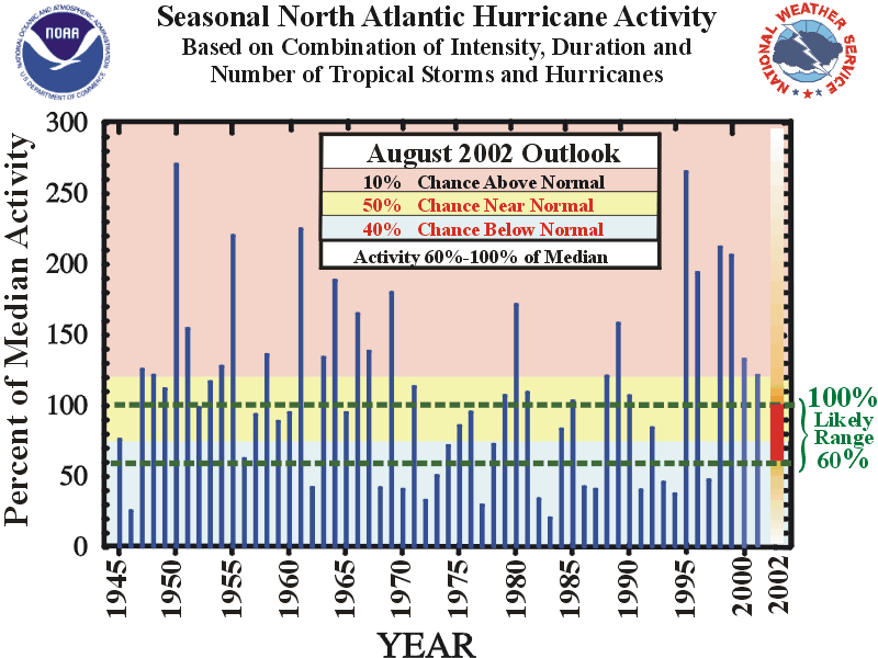
a 50% probability of a near-normal Atlantic hurricane season, a 40% probability of a
below-normal season, with a 10% probability of an above-normal season. Historical data for similar
climate conditions indicates a likely range of 7-10 tropical storms this season, 4-6 hurricanes, and 1-3
major hurricanes [categories 3-4-5 on the Saffir-Simpson scale].
Hurricane-spawned disasters can occur in years with normal or
below-normal levels of activity.
DISCUSSION
El Niño has strengthened to nearly moderate intensity during the
past two months and is now expected to have a suppressing influence on upcoming Atlantic
hurricane activity. As a result the probability of a below-normal season has increased
from 20% to 40% compared to the outlook issued on 20 May. Conversely, the likelihood of an above-normal
season has decreased from 35% to 10%, and the probability of a near-normal season has increased slightly
from 45% to 50%.
1. Expected Level of Overall Activity - Normal
to below normal
Using the "Accumulated Cyclone Energy" (ACE)
index as the basis for measuring overall seasonal activity (see Background
Information), the total 2002 activity is expected to range between 60%-100% of the
long-term median ACE value. As indicated in
the Background Information, a seasonal ACE value below 76% of the median represents the
threshold for a below-normal season.
Historical data for similar
climate conditions indicates a likely range of 7-10 tropical storms this season, 4-6
hurricanes, and 1-3 major hurricanes [categories 3-4-5 on the Saffir-Simpson scale].
While it is reasonable to expect this range of tropical storms and hurricanes, the season can
certainly feature normal to slightly below-normal levels of activity without all three of these
criteria being met.
Based on past historical data
similar seasons have also averaged about 1 landfalling hurricane in the continental
United States and about 1 hurricane in the region around the Caribbean Sea.
However, it is important to recognize that it is
currently not possible to confidently predict at these extended ranges the exact number of
U.S. landfalling hurricanes, the intensity of the landfalling hurricanes, or whether a
particular locality will be impacted by a hurricane this season.
2. Climate Conditions-
El Niño expected to reduce seasonal activity
Competing primary and secondary climate signals are guiding this
Atlantic hurricane outlook. One primary climate signal is El
Niño, which is expected to contribute to higher vertical wind shear in the main hurricane
development region, thereby reducing hurricane activity compared to the last several
seasons. The strengthening El Niño episode
is the main basis for lowering the expected activity indicated in the May outlook.
The other primary climate factor influencing this year's
seasonal activity is the ongoing multi-decadal signal, which is again evident in the
favorable configuration of the African easterly jet and low-level westerly wind anomalies
across the tropical Atlantic. Similar conditions contributed to the active decades of the
1950's and 1960's, and to the dramatic upturn in hurricane activity observed since 1995.
See the recent paper by Goldenberg et al. (2001) in Science for more details.
Competing signals are also coming from secondary climate factors.
Currently, tropical North Atlantic sea surface temperatures are slightly cooler than average,
suggesting less overall activity in 2002 compared to the past several seasons.
However, anomalously westerly winds in the lower stratosphere are expected to provide a slightly
enhancing influence on overall Atlantic hurricane activity this season.
3. Uncertainties
Because of the time of year and strong intra-seasonal variability
associated with the Madden-Julian Oscillation (MJO), the El Niño- related wind anomalies
have not yet become well defined over the tropical Atlantic. Therefore, the time of onset of the El
Niño-related vertical wind shear over the tropical North Atlantic during the peak months
(August-October) of the hurricane season represents a source of uncertainty in this
season's outlook. NOAA will continue to closely monitor these evolving conditions in the Tropics.
CAUTIONARY NOTES
1) It is important to recognize that it is
currently not possible to confidently predict at these extended ranges the number of U.S.
landfalling hurricanes, the intensity of the landfalling hurricanes, or whether a
particular locality will be impacted by a hurricane this season.
Therefore, residents and government agencies
coastal and near-coastal regions should always maintain hurricane preparedness efforts
regardless of the overall seasonal outlook
2) Far more damage can be done by one
major hurricane hitting a heavily populated area than by several hurricanes hitting
sparsely populated areas or, of course, not making landfall at all. Therefore, hurricane-spawned disasters can occur
even in years with near-normal or below-normal levels of activity. Examples of years
with near-normal levels of activity that featured extensive hurricane damage and numerous
fatalities include 1960 (Hurricane Donna), 1979 (Hurricanes David and Frederic), and 1985
(Hurricanes Elena, Gloria and Juan). Moreover,
the nation's most damaging hurricane, Andrew in 1992, occurred during a season with
otherwise below normal overall activity.
FORECASTERS
Dr. Gerald Bell, Meteorologist, Climate Prediction
Center; gerry.bell@noaa.gov
Mr. Eric Blake, Meteorologist, Tropical Prediction Center;
eric.s.blake@noaa.gov
Dr. Muthuvel Chelliah, Physical Scientist, Climate
Prediction Center; muthuvel.chelliah@noaa.gov
Mr. Stanley Goldenberg, Meteorologist, Hurricane
Research Division; stanley.goldenberg@noaa.gov
Dr. Christopher Landsea, Meteorologist, Hurricane
Research Division; chris.landsea@noaa.gov
Dr. Kingste Mo, Meteorologist, Climate Prediction
Center; kingste.mo@noaa.gov
Dr. Richard Pasch, Meteorologist, National
Hurricane Center; richard.j.pasch@noaa.gov
|


