|
Synopsis: Synopsis: La Niña conditions are expected to strengthen and last through the Northern Hemisphere winter 2010-11.
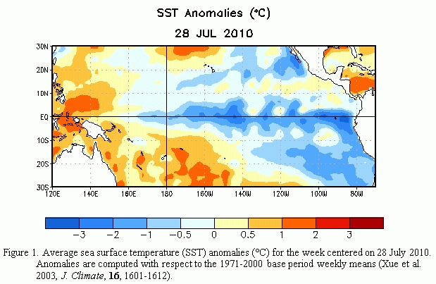
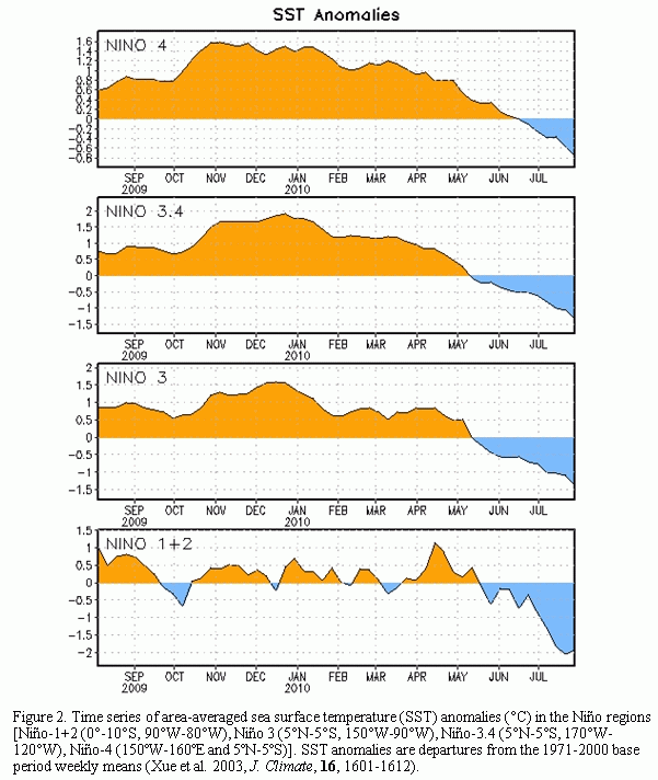
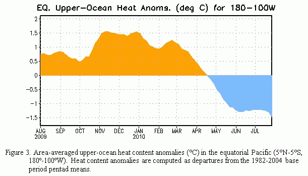
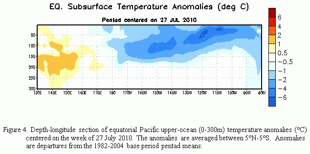
During July 2010 La Niña conditions developed, as negative sea surface temperature (SST) anomalies strengthened across the central and eastern equatorial Pacific Ocean (Fig. 1). All of the Niño indices decreased with values less than -1.0oC in Niño 1+2, 3, and 3.4 regions at the end of the month (Fig. 2). The subsurface heat content (average temperatures in the upper 300m of the ocean, Fig. 3) continued to reflect a deep layer of below-average temperatures east of the Date Line (Fig. 4). Also convection was enhanced over Indonesia, while remaining suppressed over the western and central tropical Pacific (Fig. 5). Enhanced low-level easterly trade winds and anomalous upper-level westerly winds continued over the western and central equatorial Pacific. Collectively, these oceanic and atmospheric anomalies reflect the development and strengthening of La Niña conditions.
Nearly all models predict La Niña to continue through early 2011 (Fig. 6). However, there is disagreement among the models over the eventual strength of La Niña. Most dynamical models generally predict a moderate-to-strong La Niña, while the majority of the statistical model forecasts indicate a weaker episode. Given the strong cooling observed over the last several months and the apparent ocean-atmosphere coupling (positive feedback), the dynamical model outcome of a moderate-to-strong episode is favored at this time. Therefore, La Niña conditions are expected to strengthen and last through Northern Hemisphere Winter 2010-11.
Expected La Niña impacts during August-October 2010 include suppressed convection over the central tropical Pacific Ocean, and enhanced convection over Indonesia. Temperature and precipitation impacts over the United States are typically weak during the Northern Hemisphere summer and early fall, but strengthen considerably during late fall and winter. Also, La Niña can contribute to increased Atlantic hurricane activity by decreasing the vertical wind shear over the Caribbean Sea and tropical Atlantic Ocean (see the August 5th update of the NOAA Atlantic Seasonal Hurricane Outlook).
This discussion is a consolidated effort of the National Oceanic and Atmospheric Administration (NOAA), NOAA's National Weather Service, and their funded institutions. Oceanic and atmospheric conditions are updated weekly on the Climate Prediction Center web
site (El Niño/La Niña Current
Conditions and Expert Discussions). Forecasts for the evolution of El Niño/La Niña are updated monthly in the
Forecast Forum section of CPC's Climate
Diagnostics Bulletin. The next ENSO Diagnostics Discussion is scheduled for 9 September 2010. To receive
an e-mail notification when the monthly ENSO Diagnostic Discussions are released, please send an e-mail message
to: ncep.list.enso-update@noaa.gov.
|


