An Overview of Reanalysis-2
by
Masao Kanamitsu, Wesley Ebisuzaki
Climate Prediction Center, NCEP
Washington, DC
Jack Woolen
Environmental Modeling Center, NCEP
Washington, DC
Jerry Potter, Michael Fiorino
PCMDI, Lawrence Livermore National Laboratory
Livermore, CA
Introduction
Attempt to correct known errors
in the NCEP/NCAR reanalysis.
-
Computational resource was
provided by
PCMDI (Program
for Climate Model Diagnosis and Intercomparison) at Lawrence Livermore
National Laboratory.
-
Computations were done at the DOE's National Energy Research
Supercomputing Center (NERSC)
withCray
J90 machines.
-
Based on NCEP/NCAR Reanalysis
system with portabilityexpanded.
-
Very small effort.
Production and monitoring by 2.5 person. Less
than 1 hour total per day spent.
1979-1993 completed.
Monthly average data available on:
http://nomad3.ncep.noaa.gov/ncep_data
Features
Model resolution, data and period:
-
Same resolution as N/N Reanalysis:
T62
L28
-
Same raw observed data
-
Same dependence of satellite
temperature retrievals
-
Global 1979-1999 for the
first phase. Plan exits to go back to 1950's.
Error fixes:
-
Fix S. H. PAOBs problem (79-92)
-
Fix snow cover analysis error
(74-94)
-
Removed spectral snow problem
(entire period)
-
Fixed oceanic albedo (entire
period)
-
Fixed discontinuities in radiation
fluxes at date line due to cloud tuning (entire period)
New system components:
-
Simple rainfall assimilation for soil wetness
-
Smoothed orography
Improvements to the model:
-
New boundary layer (non-local
scheme by Hong and Pan)
-
New short wave radiation
(Chou, 1992)
-
Updated convective parameterization
-
Fix "cloud top cooling" in radiation
-
Updated cloud parameterization
and RH-cloud relationship
-
Run radiation code more
frequently (1 hr vs 3 hrs)
-
Run radiation code on full
Gaussian grid
-
Nudging of deep layer soil
wetness removed
Improved fixed fields:
-
Improved desert albedo (Briegleb 1982)
-
Improved sea-ice SST fields (AMIP-II, Mike Fiorino)
-
New ozone climatology
-
Observed snow mask interpolation to daily
-
CO2(350ppmv) AMIP-II constants
Improvement to the diagnostics:
-
Fixed snow/water budget diagnostics
-
Fixed snow melt term
-
Better cloud diagnostics field
Archive and Distribution:
-
Data kept in the NERSC mass storage
-
No tapes
and no CD-ROMs (time
consuming)
-
Distribute analysis through internet
-
NCAR will distribute the
analysis in future
Summary
Updated Reanalysis for
the satellite era.
-
Fixed known
errors in N/N Reanalysis
-
Some improvements in the
assimilation
system.
-
Improved diagnostics
-
Demonstrated that the systemcan
be ported to other sites.
-
Some diagnostics has been done outside.
-
About 1000 download, 2.5GB transfer
per month from ftp site.
Preliminary evaluation
Improvements:
-
Soil wetness, especially
the interannual variations better
-
Winter time precipitation,
surface
temp and fluxes
in high latitudes better.
-
Tropical precipitation looks
better (still with some problems)
-
Oceanic albedo more reasonable
-
Short wave radiation fluxes
look better
-
Snow cover and surface
temperature are better
Possible drawbacks:
-
R-2 overestimates OLR over
warm
pool (poster by S-K Yang)
-
Equatorial upper level moisture
R-2 much drier (over convection area)
-
Long term spin-down of soil
wetness in polar latitudes.
Major differences between R-1 and R-2:
-
Soil temperature and 2m temperature.
R-2
tend to be warmer.
-
Precipitable water in the
tropics. R-2 larger.
-
Cloud amount R-2
larger.
-
R-2 underestimates
surface downward shortwave flux
over equatorial ocean.
Other minor but notable differences:
-
Some difference of height
and temperature in the N.H. oceans
-
S.H.
Stratospheric temperature difference.
-
Hadley
circulation. Lower in R-2.
-
R-2S.H.
jet located slight to the north.
-
Equatorial
divergent winds different.
N/N
Reanalysis and Reanalysis-2
-
Two analyses should go
together. They have same resolution, similar output, and files making
comparison easy.
-
The comparison
of two analyses provide important information on the sensitivity
of
the analysis to change in analysis systems.
It also provides some measure of the analysis error.
-
Reanalysis-2
should be used by user affected by
known
errors in the N/N Reanalysis.
-
Analysis of transients
(particularly case studies) in S. H. mid-high latitudes
-
Use of near
surface temperature and snow cover over the N. H. continents in
winter.
-
Analysis of
snow budget.
-
Reanalysis-2
will provide more accurate
picture of:
-
Soil
wetness and near
surface temperature
-
Hydrological budget
-
Winter precipitationin
polar
regions
-
Hydrological andenergy
budgetin polar regions
-
Snow
cover
-
Reanalysis-2
may not be better than
N/N Reanalysis in some fields.
-
Reanalysis-2
should not be regarded as a next generation N/N Reanalysis
Selected
difference maps between R1, R2 (and ERA40).
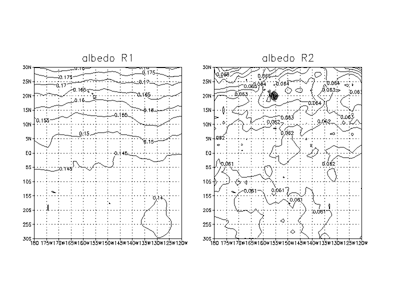
1.
Albedo over ocean : Error fix in radiation
Note that R1 has unrealistic albedo
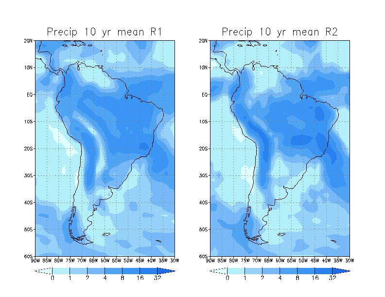
2.
Precipitation
over south America : Effect of smoothed orography in R2.
Note that R1 preciptation is noisy over Amazon basin.
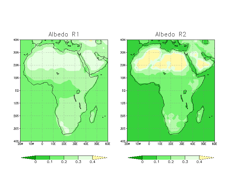
3.
Albedo over Africa : Improved desert albedo
in R2
Note that R2 has higher albedo over Sahara desert.
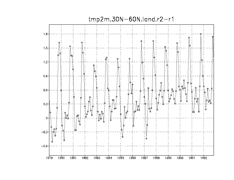
4.
Land area averaged 2 m temperature
(30N-60N) : Effect of corrected snow cover analysis.
Note the peak difference in fall seasons.
5.
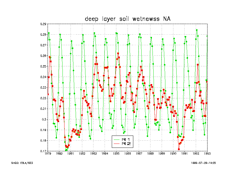
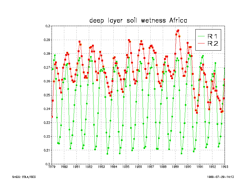
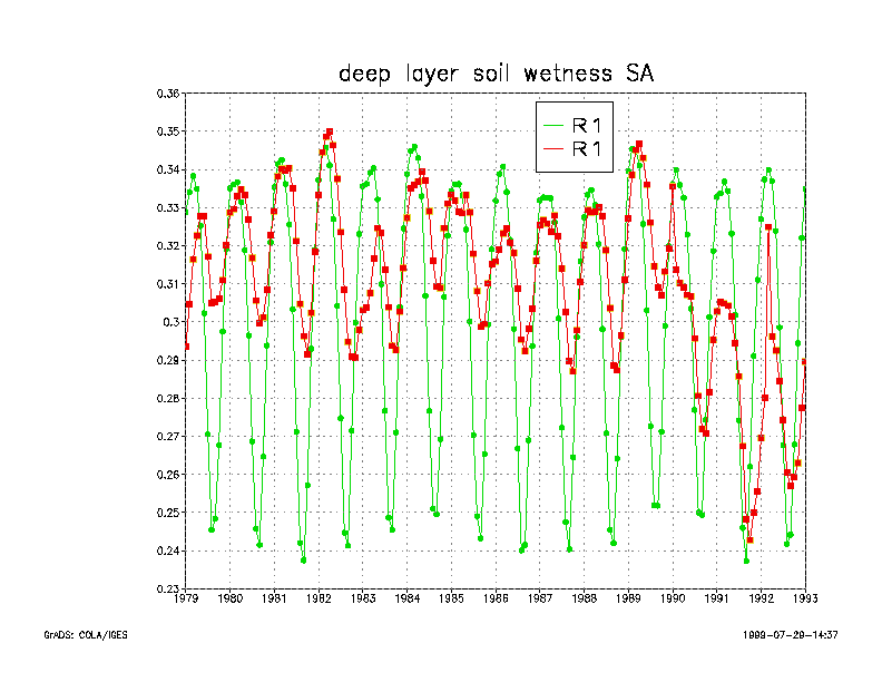
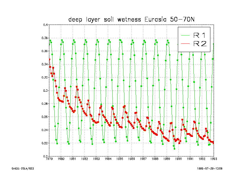
Soil moisture comparisons : Effect of using observed pentad precipitation
in R2
Note much larger interannual variability in R2
5.1 Soil moisture over North America
Dry condition in some of the years may not be accurate due
to possible problems in observed pentad precipitation.
5.2 Soil moisture over Africa
5.3 Soil moisture over South America
5.4 Soil moisture over Eurasia polar
region
Note the very slow spin down in soil wetness over this region
6.
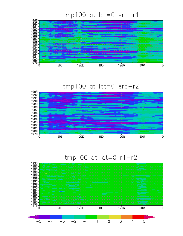
Temperature
at 100 hPa at the equator : Difference due to parameterization
Note that difference between R1 and R2 is much smaller than
the difference between R1, R2 and ERA. This may be
due to difference in model as well as to the way satellite data was used
(NESDIS retrieval for R1, R2 and 1-D variational
analysis for ERA).