HOME> Expert Assessments>Hazards Outlook
For 3-7 day hazards see Weather Prediction Center's: WPC 3-7 Day Hazards
U.S. Week-2 Hazards Outlook - Made June 27, 2025 | About the Hazards Outlook
ATTENTION:
We would like to hear from you! Please provide your feedback and suggestions about these outlooks by taking the customer satisfaction survey HERE.
| Composite Map Day 8-14 |
Experimental Probabilistic Outlooks |
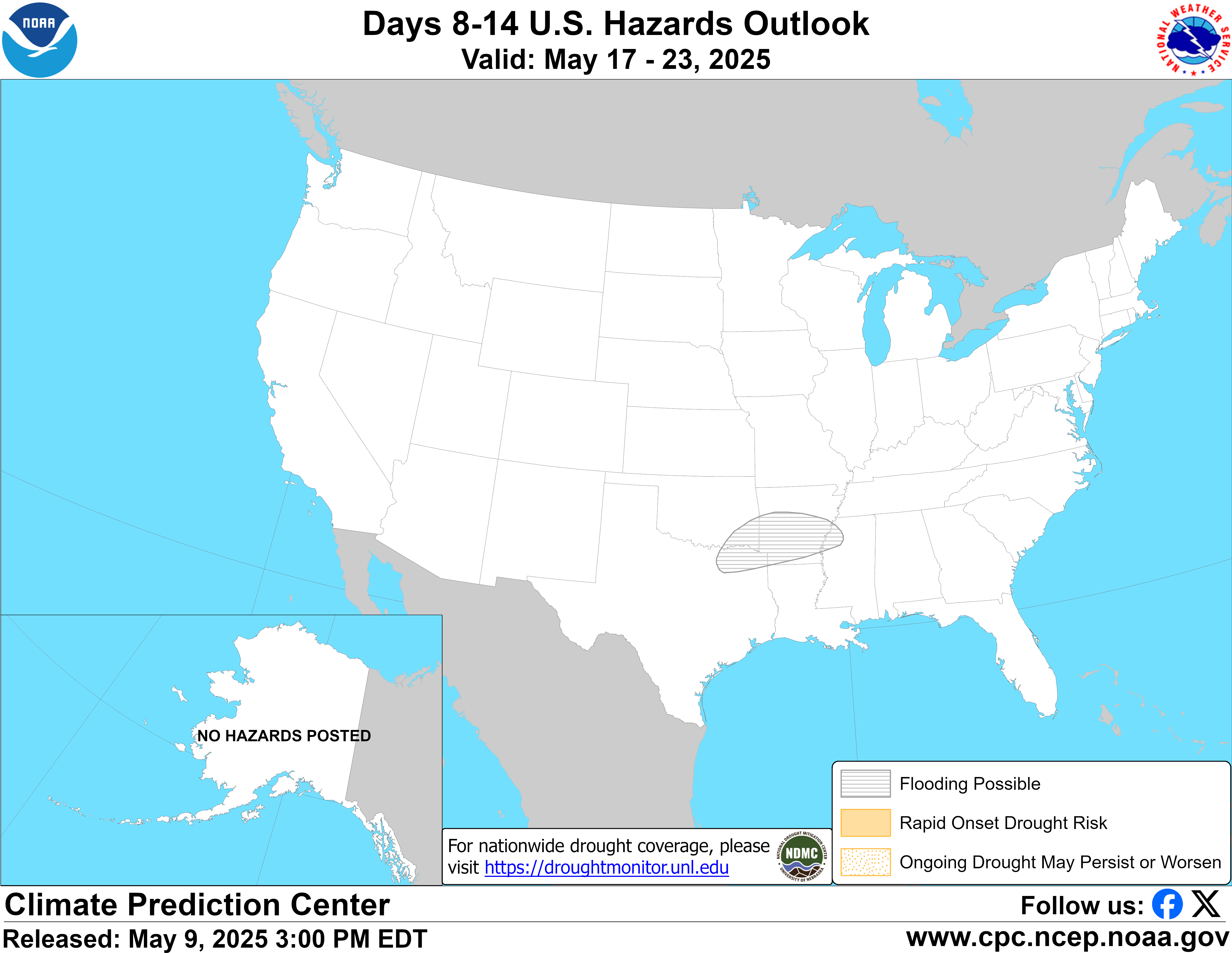 |
Valid Saturday July 05, 2025 to Friday July 11, 2025
US Hazards OutlookNWS Climate Prediction Center College Park MD
300 PM EDT June 27 2025
Synopsis: Mid-level high pressure forecast across the south-central contiguous U.S. (CONUS) favors increased chances for extreme heat across the region during week-2. Dynamical models depict this feature shifting westward and amplifying throughout the period, increasing concerns for extreme heat conditions developing across the western CONUS by the second half of the period. While monsoon activity is predicted to diminish across the Southwest heading into week-2, daytime convection remains possible resulting in lingering heavy precipitation and flooding concerns.
Hazards
- Slight risk of heavy precipitation for parts of the Desert Southwest, Rockies, and Great Basin, Sat-Mon, Jul 5-7.
- Slight risk of extreme heat over parts of the Southern Plains and Lower Mississippi Valley, Sat-Fri, Jul 5-11.
- Slight risk of extreme heat over interior parts of California, the Southwest, the Great Basin, and portions of the Northern Rockies, Tue-Fri, Jul 8-11.
- Slight risk of high winds along most of the immediate West Coast, Sat-Tue, Jul 5-8.
- Flooding possible over portions of Arizona and New Mexico.
For Monday June 30 - Friday July 04: WPC Days 3-7 U.S. Hazards
For Saturday July 05 - Friday July 11: Monsoon activity is forecast to diminish at the start of week-2 across the Southwest, with the strongest signals for enhanced precipitation now appearing in the late week-1 timeframe. This is reflected in the GEFS and ECENS Probabilistic Extremes Tools (PETs) which show reduced probabilities for hazardous precipitation totals compared to yesterday. Therefore, the moderate risk of heavy precipitation has been discontinued. A slight risk for heavy precipitation remains posted through Jul 7 given the continued likelihood of enhanced daytime convection. Due to locally heavy precipitation received over portions of New Mexico, any additional precipitation during week-2 is likely to worsen saturated ground conditions and possibly trigger additional flooding in the region. A flooding possible hazard remains issued and includes many parts of Arizona where locally heavy precipitation may also trigger flash flooding and debris flows near recently burned areas. In addition to flash flooding, thunderstorm impacts may include lightning, gusty winds and blowing dust. However, in spite of these potentially adverse but localized impacts, some areas experiencing moderate to exceptional drought conditions and wildfires will benefit from the enhanced rainfall.
Dynamical models, particularly the 0z ECENS, continue to depict a strengthening subtropical ridge across the southern U.S. The PETs are fairly modest with probabilities for temperatures exceeding the 85th climatological percentile at the start of the period across the south-central states, but humidity is likely to result in higher heat index values. As the ridge axis amplifies and expands westward, heat signals increase. By the end of the period, both the uncalibrated 0z ECENS and GEFS depict actual temperatures above 100 deg F over portions of Texas and Oklahoma, with a corresponding uptick in the probabilities in the PETs. The calibrated skill weighted heat tool depicts probabilities of 40-70 percent for heat index values exceeding the 95th climatological percentile across the region, with some areas potentially having heat index values above 110 deg F. As a result of these enhanced signals, the slight risk for extreme heat is posted for all of week-2 across portions of the Southern Plains and Lower Mississippi Valley. Due to the stronger signals emerging later in the period, a moderate risk may be considered next week if trends continue.
Extreme heat concerns may expand into the West later in the period, with the 0z ECENS depicting a 597-dm ridge axis moving over the Four Corners Region. The 0z GEFS and CMCE also show this feature, but a bit weaker in magnitude. For now, a broad slight risk of extreme heat is posted from the Southwest, across the Great Basin to the Northern Rockies Jul 8-11 where the GEFS and ECENS PETs depict expanding coverage of probabilities for maximum temperatures exceeding the 85th climatological percentile initially across the Great Basin and then reaching the Desert Southwest and California Central Valley by the end of the period. Predicted temperatures range from the mid-90s deg F across the northern Great Basin to possibly above 110 deg F across the Desert Southwest. Another complicating factor is the potential for renewed enhancement of the Southwest monsoon given the ridge axis placement becoming more favorable. This could result in some areas of the Southwest having relatively lower temperatures, as well as further prolonging the heavy precipitation and flooding risks discussed earlier.
A more variable summer-like pattern is predicted across the East. While the PETs depict an elevated signal for temperatures exceeding the 85th climatological percentile across the Ohio Valley and Mid-Atlantic early in the period, the actual temperatures in the uncalibrated guidance are not extreme by July standards (generally upper 80s to low 90s deg F) precluding a related extreme heat hazard. The ECENS PET continues to depict an enhanced precipitation signal extending across the Midwest and Northeast Jul 5-7, with some areas having probabilities of at least 20 percent for precipitation totals exceeding the 85th climatological percentile and 1-inch. This could be indicative of a frontal system propagating around the ridge axis across the southern and western states. The GEFS PET is not as robust with these probabilities, although the uncalibrated 0z GEFS depicts the same frontal feature, but just to a lesser extent than the ECENS. No related precipitation hazard is posted given the system looks to be progressive, and precipitation totals would be in line with expectations for the time of year.
Surface high pressure over the northeastern Pacific adjacent to mean surface low pressure over the Interior West may lead to tight pressure gradients along much of the West Coast. As a result, a slight risk of high winds remains posted along most of the immediate West Coast Jul 5-8 where the ECENS PET also indicates increased chances for wind speeds exceeding the 85th climatological percentile. The aforementioned ridging predicted to build over the West may help to reduce pressure gradients along the coast by the second half of the period.
Shortwave troughing forecast to move into western Alaska favors enhanced chances for above-normal precipitation across most of the state along with relatively cooler temperatures. This may provide some wildfire relief during the week-2 period. However, the smoke generated by these fires is forecast to continue to meander around the state, following low-level wind currents. As a result, periods of very poor air quality and low visibility may occur, especially over Interior areas of Mainland Alaska that do not receive as much precipitation.
Forecaster: Thomas Collow
$$ Please consult local NWS Forecast Offices for short range forecasts and region-specific information.
Resources
Week-2 Probabilistic Extremes Tool
GFS Ensemble Forecasts