|
|
General Information
|
Forecast Tools
|
Verification
|
Related Outlooks
|
About Us
|
Contact Us
|
As of the May 19th, 2017, release, Week 3-4 outlooks precipitation outlooks are experimental, whereas the temperature outlooks are operational. Both are issued Friday between 3pm & 4pm Eastern Time.
|
|
|
HOME>
Outlook Maps>
Week 3-4 Outlooks
|
|
|
Week 3-4 Outlooks
|
Valid: 26 Jul 2025 to 08 Aug 2025
Updated: 11 Jul 2025
|
|
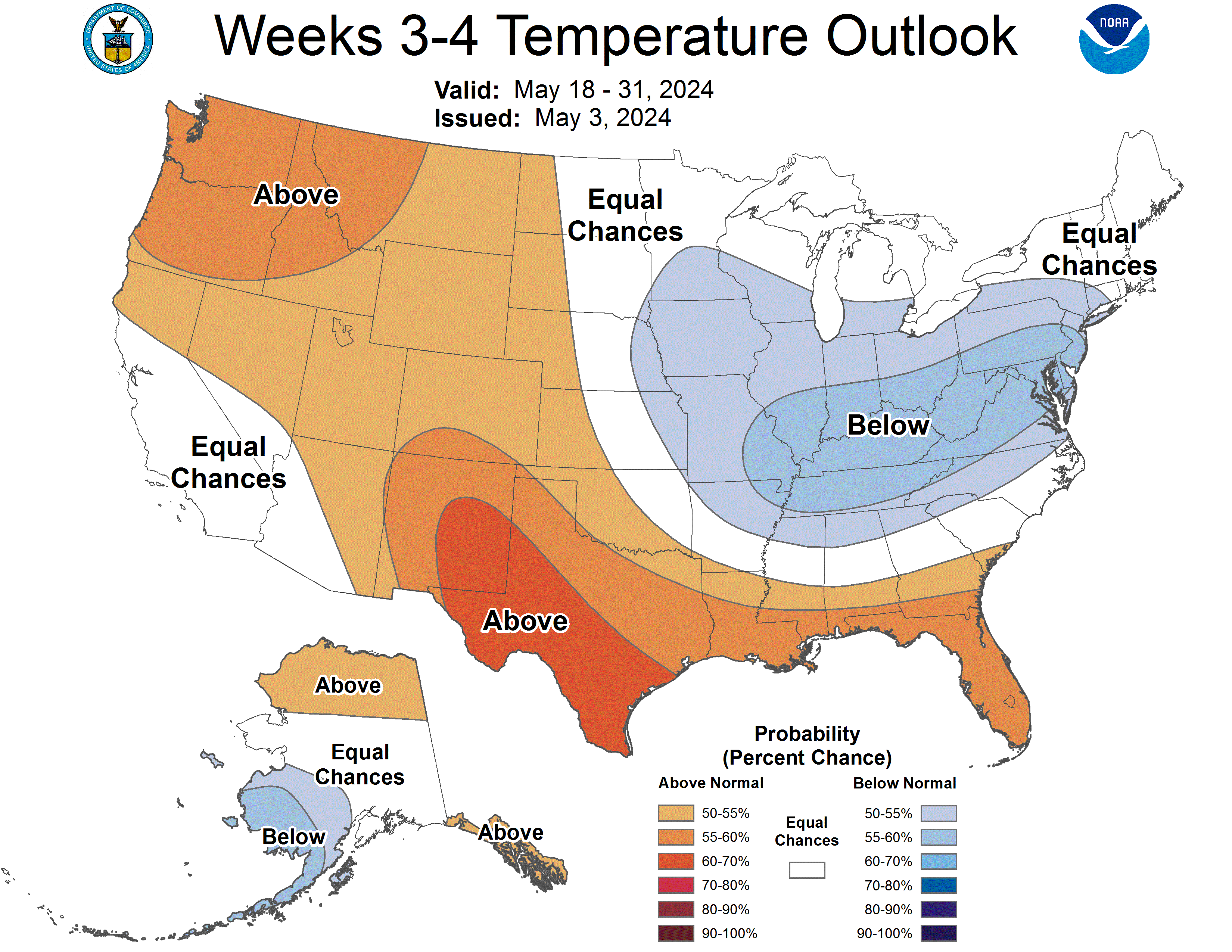
Temperature Probability
|
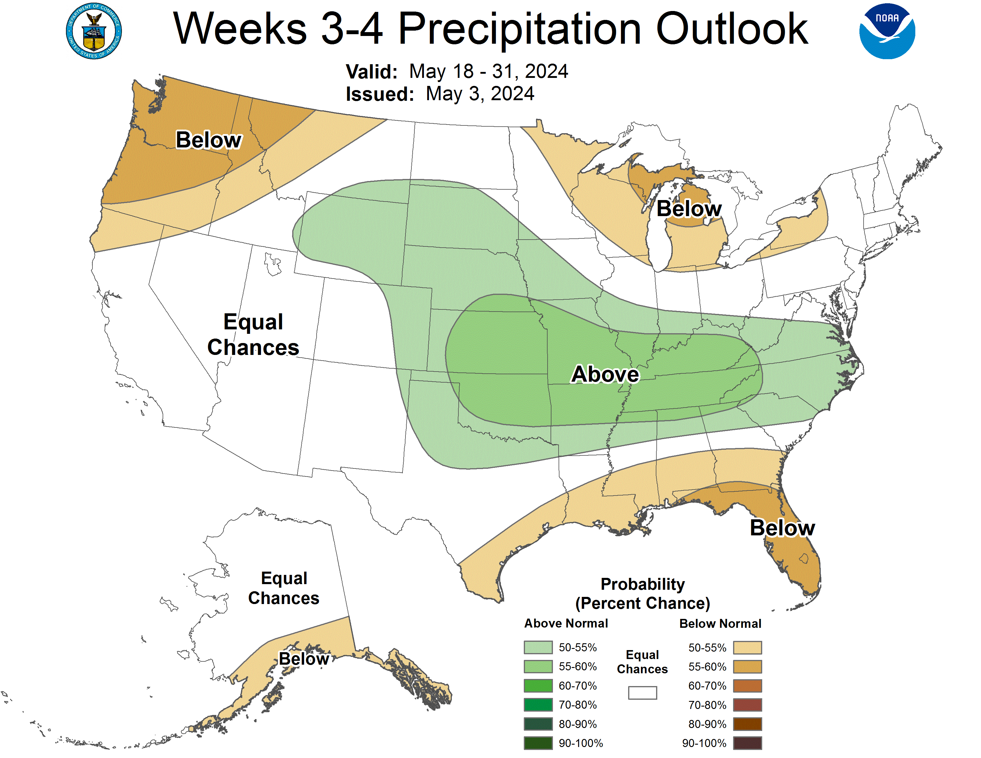
Precipitation Probability
|
Week 3-4 500-hPa Height Outlook
|
|
Click HERE for info about how to read Week 3-4 outlook maps
|
|
Prognostic Discussion for Week 3-4 Temperature and Precipitation Outlooks
NWS Climate Prediction Center College Park MD
300PM EDT Fri Jul 11 2025
Week 3-4 Forecast Discussion Valid Sat Jul 26 2025-Fri Aug 08 2025
ENSO Alert System Status is Not Active. ENSO-neutral conditions continue. Sea surface temperatures (SSTs) across the equatorial Pacific Ocean are near normal. ENSO-neutral conditions are likely to persist during the Northern Hemisphere summer this year with an 82% chance thru August and may continue into winter, however confidence is lower at 48% chance of neutral conditions and a 41% chance of La Niña conditions from November to January.
Despite the recent history of a disorganized MJO, with other tropical modes providing the bulk of the variability throughout the global tropics, dynamical model forecasts of RMMs indicate a reemergence of the MJO at the time of this forecast. If this reemergence holds, the large-scale environment could be more favorable for tropical cyclogenesis in the eastern Pacific and Atlantic basins later in August. A low-frequency response appears to be emerging, with some model guidance strengthening a stationary envelope of enhanced convection over the Maritime Continent and West Pacific, and suppressed convection favored in the central and eastern Pacific, and the Western Indian Ocean, during July.
A blend of the dynamical model 500-hPa height anomalies indicates largely above average heights across most of CONUS and Alaska with hints toward a weakness in the ridging off the West Coast and the Hudson Bay. ECMWF and the experimental ECCC models both bring a troughing signal further south from the Hudson Bay toward the U.S. Southeast. JMA forecasts a small area of weak troughing over the Southwest.
Dynamical models broadly agree on warmer than average conditions for the Pacific Northwest, the Midwest, the Southern Plains, and the Southeast. ECMWF is steadfast with a cooler than average forecast for the Great Lakes region while JMA is bullish on cooler than average temperatures across the Southwest and southern West Coast. The highest confidence in warmer than average temperatures is forecast for the Southern Plains and Southeast with moderate chances of warmer than average conditions extending through the Midwest. The forecast also favors a slight chance of warmer than average conditions across the Intermountain West. Equal Chances is forecast for the Great Lakes region in deference to the ECMWF forecast. The Southwest is also forecast with Equal Chances due to the mixed model guidance in the region, as well as the ongoing monsoon. Alaska is forecast with low-to-moderate chances of warmer than average conditions during the outlook period.
Dynamical models indicate a drier than average forecast for the Southern and Central Plains, with some variation on the extent and local maxima of the dry signal. Models also generally agree on a continued wetter than average signal for the Southwest, however again, with variation on the extent and local maxima of the wet signal. Equal Chances is forecast for the Midwest and Eastern Seaboard given the model guidance indicates mixed small scale differences in wetter or drier signals for the region, along with weak probabilities. Equal Chances is also forecast for the West Coast and Northern Rocky Mountains given the mixed model guidance for the area and the climatologically arid nature of the region during summer. Alaska is forecast with low-to-moderate chances of wetter than average conditions for most of the state, except for southeastern Alaska where Equal Chances is forecast due to mixed model guidance in the region.
For Hawaii, surrounding SST anomalies are above normal, however are trending toward normal. The temperature outlook favors above normal temperatures for Hilo and Kahului and near normal temperatures for Honolulu and Lihue. Wetter than average conditions are forecast for Lihue and Honolulu while near normal rainfall is forecast for Kahului, and below average rainfall is forecast for Hilo.
| Temperature | Precipitation |
| FCST | FCST |
| Hilo | A60 | B55 |
| Kahului | A60 | EC |
| Honolulu | EC | A60 |
| Lihue | EC | A60 |
Forecaster: Emerson LaJoie
The next week 3-4 outlook will be issued on Friday, Jul 18, 2025
These outlooks are based on departures from the 1991-2020 base period
These are two category outlooks and differ from official current three category outlooks currently used for the monthly and seasonal forecasts.
The shading on the temperature map depicts the most favored category, either above-normal (A) or below-normal (B) with the solid lines giving the probability ( >50%) of this more likely category (above or below).
The shading on the precipitation map depicts the most favored category, either above-median (A) or below-median (B) with the solid lines giving the probability ( >50%) of this more likely category (above or below).
In areas where the likelihoods of 2-week mean temperatures and accumulated precipitation amounts are similar to climatological probabilities, equal chances (EC) is indicated.
|
|
|
|
An ASCII (w/ HTML markup tags) text version of the written forecast is available.
|
|
|


