|
The 2009 Atlantic hurricane season outlook is an
official product of the National Oceanic and Atmospheric Administration (NOAA) Climate Prediction Center (CPC),
and is produced in collaboration with scientists from the National Hurricane Center (NHC) and Hurricane Research
Division (HRD). The Atlantic hurricane region includes the North Atlantic Ocean, Caribbean Sea, and Gulf of
Mexico.
Interpretation of NOAA’s Atlantic seasonal hurricane outlook
This outlook provides a general guide to the expected overall strength of the upcoming hurricane season. This
outlook is not a seasonal hurricane landfall forecast, and does not imply levels of activity for any particular
region.
Preparedness
- Hurricane disasters can occur whether the season is active or
relatively quiet. Residents, businesses, and government agencies of coastal and near-coastal regions are urged
to prepare for every hurricane season regardless of the seasonal outlook. NOAA, FEMA, NHC, Small Business
Administration, and the American Red Cross all provide important hurricane preparedness information on their
web sites. It only takes one hurricane (or even a tropical storm) to cause a disaster. Be prepared!
NOAA does NOT make seasonal hurricane landfall predictions
- NOAA does not make seasonal hurricane landfall predictions. Hurricane
landfalls are largely determined by the weather patterns in place as the hurricane approaches, which are only
predictable when the storm is within several days of making landfall.
Nature of this Outlook and the “likely” ranges of activity
- This outlook is probabilistic, meaning the stated “likely” ranges
of activity have a certain likelihood of occurring. These “likely” ranges are typically are seen in about 70%
of seasons having similar climate patterns to those expected this year.
- These “likely” ranges do not represent the total range of activity
seen in past seasons having similar climate conditions to those expected this year, but are simply the most
likely.
- The outlook is based on 1) predictions of large-scale climate
factors known to be strong indicators of seasonal Atlantic hurricane activity, 2) promising new climate models
that are now beginning to directly predict seasonal hurricane activity.
Two sources of uncertainty in this August 2009 outlook
- Predicting El Niño’s strength and impacts is an ongoing
scientific challenge facing climate scientists today. There is currently a considerable spread among the El Niño
forecast models in the predicted strength of El Niño during the upcoming peak months (August-October) of the
Atlantic hurricane season.
- Many combinations of named storms and hurricanes can occur for the
same general set of climate conditions. For example, one cannot know with certainty whether a given climate
signal will be associated with several short-lived storms or fewer longer-lived storms with greater intensity.
2009 Updated Atlantic Hurricane Season Outlook: Summary
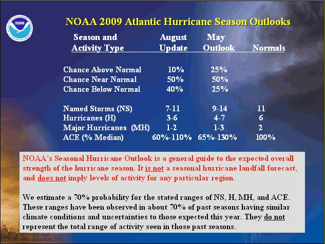
NOAA’s updated 2009 Atlantic Hurricane Season Outlook indicates a 90% chance of a near-normal or below normal hurricane season. These seasons are classified using the ACE index, which accounts for the combined intensity and duration of the total named storms and hurricanes, and NOT by the numbers of named storms and hurricanes. The Atlantic hurricane region includes the North Atlantic Ocean, the Caribbean Sea, and the Gulf of Mexico.
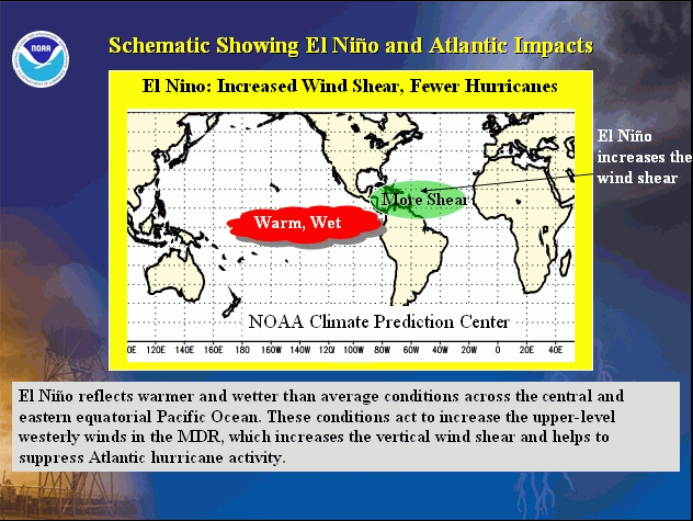
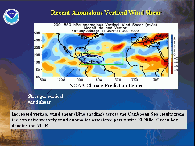
This outlook reflects two competing climate factors. The ongoing multi-decadal signal remains in place and has been associated with elevated levels of Atlantic hurricane activity since 1995, along with warmer than average sea surface temperatures (SSTs) in the tropical North Atlantic Ocean and Caribbean Sea. Offsetting this signal is El Niño, which developed in the tropical Pacific Ocean during June and is already producing increased wind shear in the Main hurricane Development Region (MDR, consisting of the tropical North Atlantic Ocean and Caribbean Sea).
This combination of climate factors indicates a 50% chance of a near-normal hurricane season for 2009, and a 40% chance of a below normal season. An above-normal season is not likely (10% chance).
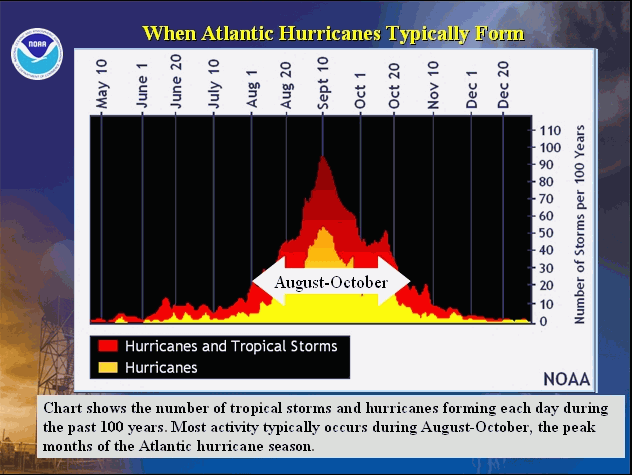
The outlook indicates a 70% probability for each of the following seasonal ranges: 7-11 named storms, 3-6 hurricanes, 1-2 major hurricanes, and an ACE range of 60%-110% of the median. Most of this activity is expected during the upcoming peak months (August-October) of the hurricane season.
These predicted ranges have been observed in about 70% of past seasons having similar climate conditions to those expected this year. They do not represent the total range of activity seen in those past seasons.
NOAA’s seasonal outlook issued in May reflected the possibility that El Niño would develop during the hurricane season. El Niño has now developed, and the Climate Prediction Center is issuing El Niño advisories.
El Niño is now expected to substantially offset the ongoing multi-decadal signal and warmer Atlantic SSTs. Consequently, the probability of a below-normal season has increased compared to the May outlook, and the predicted range of tropical cyclone activity has decreased. The May outlook called for 9-14 named storms, 4-7 hurricanes, 1-3 major hurricanes, and an ACE range of 65%-130% of the median. It indicated a 50% chance of a near normal season, and a 25% chance each for an above-normal and a below-normal season.
NOTE:
- This outlook is not a seasonal hurricane landfall forecast, and it does not imply levels of activity for any particular region.
- East Coast and Gulf Coast residents are under a hurricane threat each and every season regardless of the seasonal outlook, and it only takes one hurricane strike in your locality to make for a bad year. Hurricane strikes in the U.S. during El Niño include Betsy (1965), Bob (1991), Danny (1997), and Lili (2002).
- Examples of hurricane-related disasters during normal to below-normal seasons include Hurricane Donna (1960), Hurricane Betsy (1965), and Hurricane Andrew (1992).
- Residents, businesses, and government agencies of coastal and near-coastal regions are urged to prepare for every hurricane season regardless of the seasonal outlook.
DISCUSSION
1. Science behind the updated 2009 Outlook
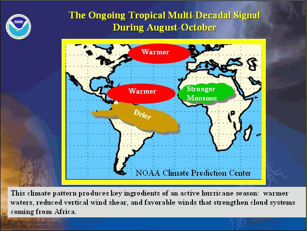
This updated 2009 seasonal hurricane outlook reflects competing impacts from the tropical multi-decadal signal (which reflects conditions associated with the ongoing high-activity era including warmer tropical Atlantic SSTs) and El Niño.
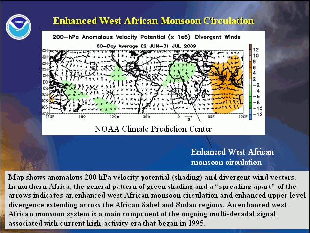
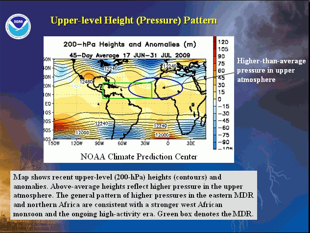
Key aspects of the multi-decadal signal are now present, including an enhanced African monsoon system, higher-than-average pressure in the upper atmosphere over the eastern tropical Atlantic Ocean and western Africa, warmer tropical Atlantic SSTs, and westerly wind anomalies at 700-hPa over the tropical Atlantic Ocean.
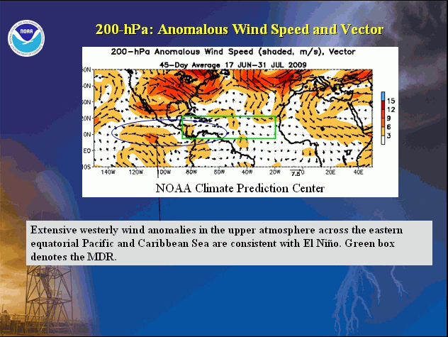
The NOAA Climate Prediction Center declared that El Niño developed during June. El Niño is now affecting the upper-level circulation throughout the global tropics and mid- latitudes, and is contributing to increased upper-level westerly winds and enhanced vertical wind shear in the western MDR. As a result, El Niño is expected to offset the ongoing multi-decadal signal, thereby reducing the strength of the 2009 hurricane season compared to the many very active seasons of recent years (Goldenberg et al. 2001; Bell and Chelliah 2006; Bell et al. 2009; NOAA 2008 seasonal hurricane summary.
2. Expected 2009 activity
NOAA’s Atlantic Hurricane Season Outlook is based on several statistical and dynamical techniques (Bell 2008). Statistical binning and regression techniques provide likely ranges of activity associated historically with a predicted set of climate factors (i.e., the tropical multi-decadal signal, El Niño, and Atlantic SST anomalies). Statistical regression equations have also been developed to predict the seasonal activity based on dynamical forecasts of atmospheric anomalies obtained from NOAA’s Climate Forecast System (CFS) System (Wang et al. 2009).
Beginning in 2008, NOAAs seasonal hurricane outlooks began incorporating high-resolution CFS simulations that directly predict the seasonal number of named storms. Another promising new model is the European Center for Medium-Range Weather Forecasts (ECMWF) Global Climate Model System 3, which also provides dynamical model predictions of upcoming seasonal hurricane activity. The outlook also considers EUROSIP (EUROpean Seasonal to Inter-annual Prediction) climate model output, which combines climate models from the ECMWF, UK Meteorological Office, and Meteo-France.
Based on these forecast techniques, and on the significant El Niño-related circulation anomalies already in place, we estimate a 90% chance of a near-normal or below-normal Atlantic hurricane season in 2009. This outlook reiterates the 50% chance of a near normal season predicted in May, and increases the probability of a below normal season to 40% chance. There is now only a 10% chance of an above-normal season.
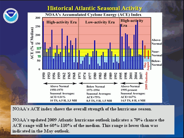
An important measure of total overall seasonal activity is NOAA’s Accumulated Cyclone Energy (ACE) index (Bell et al. 2000), which accounts for the collective intensity and duration of named storms and hurricanes during the season. There is a 70% chance the 2009 seasonal ACE value will be in the range of 60%-110% of the median. This range is lower than the 65%-130% predicted in May, and no longer includes values for an above-normal season.
According to NOAA’s definitions, an ACE index above 117% of the median reflects an above-normal season, a value of 75%-117% reflects a near normal season, and a value less than 75% reflects a below-normal season. Note that NOAA’s definitions of near-normal and below-normal seasons are based only on ACE, and NOT on the number of named storms and hurricanes.
The likely (70% chance) ranges of seasonal tropical cyclone activity for 2009 are 7-11 named storms, 3-6 hurricanes, and 1-2 major hurricanes. These ranges reflect average to below-average activity, and are less than those indicated in May (9-14 named storms, 4-7 hurricanes, and 1-3 major hurricanes).
3. Further analysis of the main climate factors
a. The Ongoing High Activity Era in the Atlantic Basin
Atlantic hurricane seasons exhibit prolonged periods lasting decades of generally above-normal or below-normal activity. These fluctuations in hurricane activity result almost entirely from differences in the number of hurricanes and major hurricanes forming from tropical storms first named in the Main Development Region (MDR), which spans the tropical Atlantic Ocean and Caribbean Sea between 30oW-87.5oW and 10oN-21.5oN (Goldenberg et al. 2001).
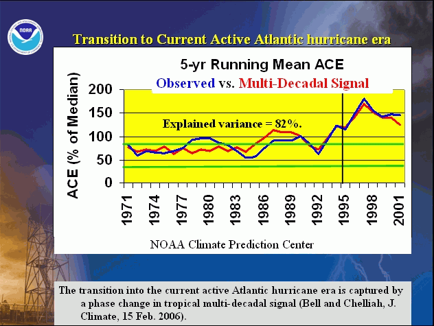
The current high-activity era began in 1995. Hurricane seasons during 1995-2008 have averaged about 15 named storms, 8 hurricanes, and 4 major hurricanes, with an ACE index of 167% of the median. NOAA classifies ten of the fourteen seasons since 1995 as above normal, with seven being hyperactive (ACE > 175% of median). Only four seasons since 1995 have not been above normal, which include three El Niño years (1997, 2002, and 2006) and the 2007 season.
This high level of activity since 1995 contrasts sharply to the 1971-1994 low-activity era (Goldenberg et al. 2001), which averaged only 8.5 named storms, 5 hurricanes, and 1.5 major hurricanes with an ACE index of 75% of the median. One-half of those seasons were below normal, only three were above normal (1980, 1988, 1989), and none were hyperactive.
The regional atmospheric circulation anomalies that contribute to these long-period fluctuations in hurricane activity are strongly linked to the tropical multi-decadal signal (Bell and Chelliah 2006). A change in phase of that multi-decadal signal accounts for the transition in 1995 from the low-activity to the high-activity era. The conditions associated with the multi-decadal signal are again a major factor guiding the 2009 outlook, including an enhanced west African monsoon system and generally above average SSTs in the MDR.
Other regional features of the multi-decadal signal now in place include 1) an amplified ridge at upper levels over the eastern subtropical North Atlantic, and weaker easterly winds in the middle atmosphere across the tropical Atlantic. In the eastern MDR, these conditions typically contribute to a configuration of the African easterly jet that is more conducive to hurricane development from tropical waves moving westward from the African coast.
b. El Niño
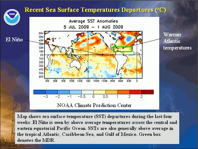
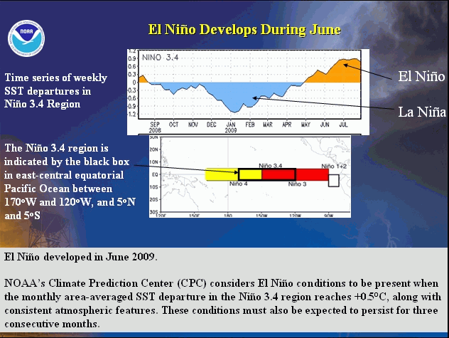
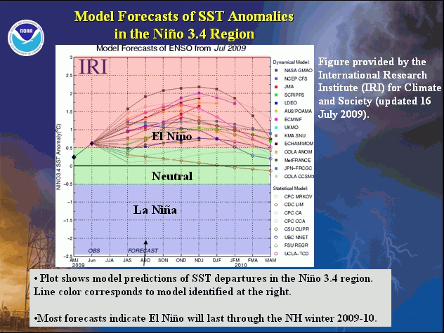
El Niño developed in June, and SSTs are now above average across the eastern half of the equatorial Pacific Ocean. For the key Niño 3.4 region (5N-5S, 120-170W), the SST anomalies during July averaged +0.9oC. NOAA’s Climate Prediction Center (CPC) considers El Niño conditions to be present when the monthly area-averaged SST departure in the Niño3.4 region reaches +0.5oC, along with consistent atmospheric features. These conditions must also be expected to persist for 3 consecutive months.
The CPC indicates weak El Niño conditions when the Niño 3.4 index is between +0.5oand +1.0oC. A moderate strength El Niño is indicated if this index is between +1.0o and +1.5oC. A strong El Niño is defined by a Niño 3.4 index exceeding +1.5oC.
The CPC, in its latest ENSO Diagnostic Advisory issued August 6th, indicates weak or moderate El Niño conditions through the hurricane season. Most dynamical and statistical models also predict a weak or moderate strength El Niño during the remainder of the season.
The analysis technique presented by Bell and Chelliah (2006) was used to quantify the atmospheric anomalies associated historically with El Niño for its current and expected strength. This analysis shows that El Niño is already having global-scale impacts on the upper-level circulation, as seen by cyclonic streamfunction anomalies at 200-hPa (see red ovals encircling blue shading in the Northern Hemisphere and red shading in the Southern Hemisphere). Over the central tropical Pacific in both hemispheres, the typical El Niño-related pattern of anticyclonic streamfunction anomalies (blue circle) is also present. Dynamical models that previously predicted this atmospheric response to El Niño continue to suggest significant impacts through the peak months of the hurricane season.
The current global-scale circulation anomalies are nearly opposite those observed last year at this time, when lingering La Niña impacts were present. Last year, the 200-hPa circulation reflected a global-scale pattern of anticyclonic anomalies at 200-hPa (see red ovals encircling red shading in the Northern Hemisphere and blue shading in the Southern Hemisphere). The typical La Niña-related pattern of cyclonic anomalies (blue circle) was also present over the central tropical Pacific in both hemispheres.
c. Atlantic SSTs
SSTs are now above-average in the MDR and Gulf of Mexico. For the entire MDR, the monthly departure during July was +0.39oC. The largest departures reached +0.5o to +1.0oC and were observed in the eastern Caribbean Sea and Gulf of Mexico. Although the magnitude of this warming is relatively modest compared to some recent exceptionally warm seasons (2003-2006, 2008), it does reflect more conducive thermodynamic and low-level wind conditions than was indicated in our May outlook.
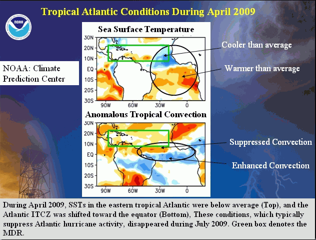
Earlier in the year SSTs in the eastern tropical Atlantic were cooler than average north of the equator and warmer than average south of the equator. This pattern reflected the negative phase of the Atlantic Meridional Mode (AMM, Chiang and Vimont 2004), and is not conducive to an active hurricane season. However, our May outlook indicated considerable uncertainty as to whether this pattern would persistent into August-October. The AMM has relaxed to near average, and is no longer expected to have a suppressing influence on the hurricane season.
NOAA FORECASTERS
Climate Prediction Center
Dr. Gerry Bell, Meteorologist; Gerry.Bell@noaa.gov
Dr. Jae Schemm, Meteorologist; Jae.Schemm@noaa.gov
National Hurricane Center
Eric Blake, Hurricane Specialist; Eric.S.Blake@noaa.gov
Todd Kimberlain, Hurricane Specialist; Todd Kimberlain@noaa.gov
Dr. Chris Landsea, Meteorologist; Chris.Landsea@noaa.gov
Dr. Richard Pasch, Hurricane Specialist; Richard.J.Pasch@noaa.gov
Hurricane Research Division
Stanley Goldenberg, Meteorologist; Stanley.Goldenberg@noaa.gov
REFERENCES
Bell, G. D., and co-authors, 2000: The 1999 North Atlantic Hurricane Season: A Climate Perspective. State of the Climate in 1999. Bull. Amer. Meteor. Soc., 81, S1-S68.
Bell, G. D., and M. Chelliah, 2006: Leading tropical modes associated with interannual and multi-decadal fluctuations in North Atlantic hurricane activity. J. of Climate. 19, 590-612.
Bell, G. D., 2008: Seasonal Forecasting of Tropical Cyclones: NOAA’s seasonal hurricane outlooks. Global Guide to Tropical Cyclones. Australian Bureau of Meteorology. Chip Guard ed.
Bell, G. D., E. Blake, C. W. Landsea, T. Kimberlain, R. Pasch, S. B. Goldenberg, and J. Schemm, 2009: Tropical cyclones- Atlantic basin. State of the Climate in 2008. Bull. Amer. Meteor. Soc., In Press. August 2009. Available at http://www.ncdc.noaa.gov/oa/climate/research/2008/ann/bams/chapter4.pdf.
Chiang, J. C. H., and D. J. Vimont: Analogous Pacific and Atlantic meridional modes of tropical atmosphere-ocean variability. J. of Climate, 17, 4143-4158
Goldenberg, S. B., C. W. Landsea, A. M. Mestas-Nuñez, and W. M. Gray, 2001: The recent increase in Atlantic hurricane activity: Causes and implications. Science, 293, 474-479.
Gray, W. M., 1984: Atlantic seasonal hurricane frequency: Part I: El Niño and 30-mb quasi-bienniel oscillation influences. Mon. Wea. Rev., 112, 1649-1668.
Wang, H., J.-K. Schemm, A. Kumar, W. Wang, L. Long, M. Chelliah, G. Bell, and P. Peng, 2009: A statistical forecast model for Atlantic seasonal hurricane activity based on the NCEP dynamical seasonal forecast. J. Climate, 22, 4481-4500.
|


