| SUMMARY
NOAA’s 2006 Atlantic hurricane season outlook indicates an 80% chance of an above-normal hurricane season, a 15% chance of a near-normal season, and only a 5% chance of a below-normal season. This outlook is produced by scientists at the National Oceanic and Atmospheric Administration's (NOAA) Climate Prediction Center (CPC), National Hurricane Center (NHC), and Hurricane Research Division (HRD). See NOAA’s definitions of above-, near-, and below-normal seasons.
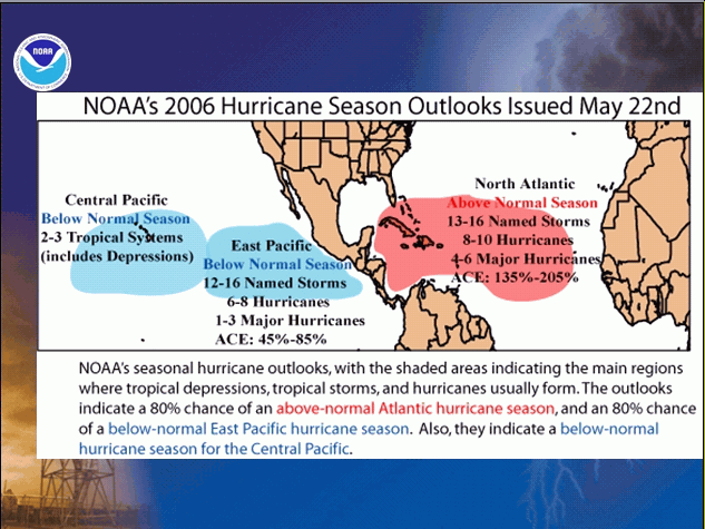
The outlook calls for a very active 2006 season, with 13-16 named storms, 8-10 hurricanes, and 4-6 major hurricanes. The likely range of the ACE index is 135%-205% of the median. This prediction indicates a continuation of above-normal activity that began in 1995. However, we do not currently expect a repeat of last year’s record season.
The predicted 2006 activity strongly reflects an expected continuation of conditions associated with the multi-decadal signal, which has favored above-normal Atlantic hurricane seasons since 1995. These conditions include considerably warmer than normal sea surface temperatures (SSTs), lower wind shear, reduced sea level pressure, and a more conducive structure of the African easterly jet. An updated Atlantic hurricane outlook will be issued in early August, which begins the peak months (August-October) of the hurricane season.
DISCUSSION
1. Expected Activity - 80% chance above normal, 15% chance near normal, 5% chance below normal
An important measure of the total seasonal activity is NOAA’s Accumulated Cyclone Energy (ACE) index, which accounts for the collective intensity and duration of Atlantic named storms and hurricanes during a given hurricane season. The ACE index is also used to define above-, near-, and below-normal hurricane seasons (see Background Information). A value of 117% of the median (Median value is 87.5) corresponds to the lower boundary for an above-normal season.
For the 2006 Atlantic hurricane season, the ACE index is expected to be in the range of 135%-205% of the median. The upper half of this range is above the 175% baseline that Goldenberg et al. (Science, 2001) use to define a hyperactive season. Based on this predicted ACE range and on the 80% probability of an above-normal season, we expect 13-16 named storms, 8-10 hurricanes, and 4-6 major hurricanes [categories 3-4-5 on the Saffir-Simpson scale]. This predicted ACE range can be satisfied even if the numbers of named storms, hurricanes, or major hurricanes fall outside their expected ranges.
The vast majority of named storms and hurricanes are expected to form during August-October over the tropical Atlantic Ocean, which is typical for above-normal seasons. These systems generally track westward toward the Caribbean Sea and/or United States as they strengthen. Historically, very active seasons have averaged 2-4 landfalling hurricanes in the continental United States and 2-3 hurricanes in the region around the Caribbean Sea. However, it is currently not possible to confidently predict at these extended ranges the number or intensity of landfalling hurricanes, and whether or not a given locality will be impacted by a hurricane this season.
2. Expected Climate Conditions – Active multi-decadal signal, above-average Atlantic Ocean temperatures, ENSO-neutral conditions
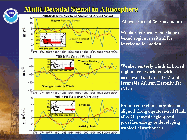
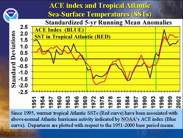
All of the Atlantic hurricane seasons since 1995 have been above normal, with the exception of two moderate to strong El Niño years (1997 and 2002). This contrasts sharply with the 1971-1994 period of generally below-normal activity (Goldenberg et al., Science, 2001). Time series of key atmospheric wind parameters highlight the dramatic differences between these above-normal and below-normal periods. Conditions were also very conducive for above-normal hurricane seasons during the 1950s and 1960s, as seen by comparing Atlantic SSTs and seasonal ACE values.
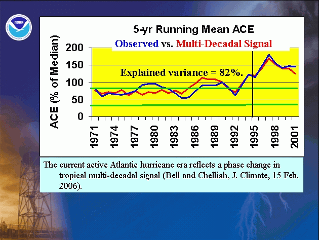
The regional atmospheric circulation contributing to these long-period fluctuations in hurricane activity is strongly linked to the tropics-wide multi-decadal signal (Bell and Chelliah, 2006). Since 1995 this signal has been very conducive to above-normal hurricane seasons and warmer Atlantic SSTs, and it is again the main factor guiding the 2006 outlook.
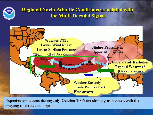
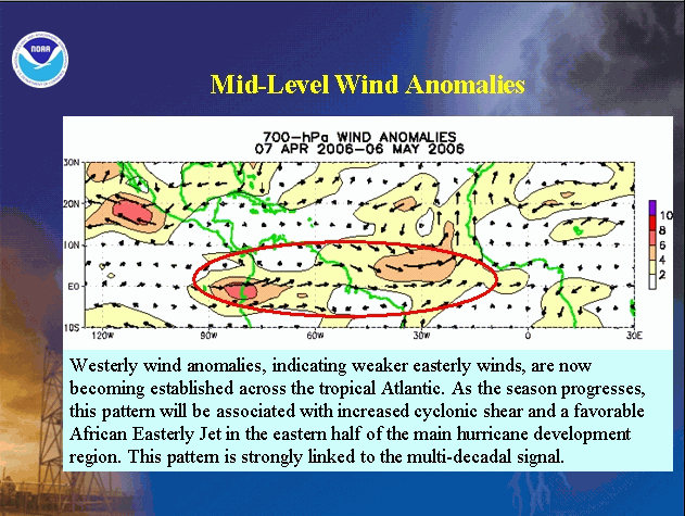
Over the North Atlantic, key aspects of the multi-decadal signal expected during the 2006 hurricane season include 1) warmer SSTs, lower surface air pressure, and increased moisture across the tropical Atlantic, 2) an amplified ridge at upper levels across the central and eastern subtropical North Atlantic, 3) reduced vertical wind shear in the deep tropics over the central North Atlantic, which results from an expanded area of easterly winds in the upper atmosphere (green arrows) and weaker easterly trade winds in the lower atmosphere (dark blue arrows), and 4) weaker easterly winds in the middle and lower atmosphere, resulting in a configuration of the African easterly jet (wavy blue arrow) that favors hurricane development from tropical waves moving westward from the African coast. Some early-season indicators of an active hurricane season are already developing. These include warmer SSTs and weaker easterly winds in the middle atmosphere, both of which have strong links to the multi-decadal signal.
Although we expect a very active hurricane season during 2006, we are not forecasting a repeat of last year’s record season at this time. This is partly because the tropical Atlantic SSTs are not presently as warm as we saw last year at this time. Also, a combination of conditions led to the record 2005 season. Some of those, particularly an amplified upper-level ridge over the eastern U.S., long periods of suppressed convection near the date line, and exceptionally low pressures in the Gulf and Caribbean Sea region, are simply not predictable at this time.
Another factor known to significantly impact Atlantic hurricane seasons is ENSO (Gray, 1984. El Niño favors fewer hurricanes and La Niña favors more hurricanes. Based on the most recent ENSO outlook issued by NOAA’s Climate Prediction Center, ENSO-neutral conditions are expected in the tropical Pacific through much of the Atlantic hurricane season. Therefore, ENSO is not expected to impact this hurricane season.
3. Multi-decadal fluctuations in Atlantic hurricane activity
Atlantic hurricane seasons exhibit prolonged periods lasting decades of generally above-normal or below-normal activity. These fluctuations in hurricane activity result almost entirely from differences in the number of hurricanes and major hurricanes forming from tropical storms first named in the main development region, which spans the tropical Atlantic Ocean and Caribbean Sea.
Hurricane seasons during 1995-2005 have averaged 15 named storms, 8.5 hurricanes, and 4 major hurricanes, with an average ACE index of 179% of the median. NOAA classifies nine of the last eleven hurricane seasons as above normal, and seven as hyperactive. In contrast, during the preceding 1971-1994 period, hurricane seasons averaged 8.5 named storms, 5 hurricanes, and 1.5 major hurricanes, with an average ACE index of only 75% of the median. One-half of these seasons were below normal, only three were above normal (1980, 1988, 1989), and none were hyperactive.
4. Uncertainties in the Outlook
The main uncertainty in this outlook is not whether the season will be above normal, but how much above normal it will be. The 2006 season could become the fourth hyperactive season in a row. Another uncertainty is related to forecasting some of the specific circulation features known to produce exceptionally active seasons. High activity during the last three seasons resulted partly from an amplified upper-level ridge and lower wind shear over the western subtropical North Atlantic and eastern United States (Bell et al. 2004, 2005, 2006). In the event these conditions again develop, which cannot be predicted with confidence at this time, the 2006 seasonal ACE value could even exceed the high end of our predicted range. However, we do not currently expect a repeat of last year’s record season.
Despite the forecasted ENSO-neutral conditions, the possibility exists for prolonged periods of suppressed convection over the central equatorial Pacific, consistent with very warm SSTs and enhanced tropical convection remaining over Indonesia and the western equatorial Pacific. Suppressed convection over the central equatorial Pacific produces a La Niña-like response in the atmospheric circulation, and results in a stronger upper-level ridge and lower wind shear over the western tropical Atlantic. The combination of an active Atlantic era and suppressed convection near the date line is known to favor extremely active Atlantic hurricane seasons, as was seen last season.
NOAA scientists will closely monitor the evolving climate conditions. NOAA’s updated Atlantic hurricane outlook will be issued in early August, which begins the peak months (August-October) of the hurricane season.
CAUTIONARY NOTES
1) It is currently not possible to confidently predict at these extended ranges the number or intensity of landfalling hurricanes, or whether a particular locality will be impacted by a hurricane this season. Therefore, residents and government agencies of coastal and near-coastal regions should always maintain hurricane preparedness efforts regardless of the overall seasonal outlook.
2) Far more damage can be done by one major hurricane hitting a heavily populated area than by several hurricanes hitting sparsely populated areas. Therefore, hurricane-spawned disasters can occur even in years with near-normal or below-normal levels of activity. Examples of years with near-normal activity that featured extensive hurricane damage and numerous fatalities include 1960 (Hurricane Donna), 1979 (Hurricanes David and Frederic), and 1985 (Hurricanes Elena, Gloria and Juan). Moreover, the nation's second most damaging hurricane, Andrew in 1992, occurred during a season with otherwise below normal activity.
NOAA FORECASTERS
Climate Prediction Center
Dr. Gerald Bell, Meteorologist; Gerry.Bell@noaa.gov
Dr. Muthuvel Chelliah, Physical Scientist; Muthuvel.Chelliah@noaa.gov
Dr. Kingste Mo, Meteorologist; Kingste.Mo@noaa.gov
National Hurricane Center
Eric Blake, Meteorologist; Eric.S.Blake@noaa.gov
Dr. Christopher Landsea, Meteorologist; Chris.Landsea@noaa.gov
Dr. Richard Pasch, Meteorologist; Richard.J.Pasch@noaa.gov
Hurricane Research Division
Stanley Goldenberg, Meteorologist; Stanley.Goldenberg@noaa.gov
REFERENCES
Bell, G. D., and M. Chelliah, 2006: Leading tropical modes associated with interannual and multi-decadal fluctuations in North Atlantic hurricane activity. J. Climate. 19, 590-612.
Bell, G. D., and Co-authors 2004: The 2003 Atlantic Hurricane Season: A Climate Perspective. State of the Climate in 2003. A. M. Waple and J. H. Lawrimore, Eds. Bull. Amer. Meteor. Soc., 85, S1-S68.
Bell, G. D., and Co-authors 2005: The 2004 Atlantic Hurricane Season: A Climate Perspective. State of the Climate in 2004. A. M. Waple and J. H. Lawrimore, Eds. Bull. Amer. Meteor. Soc., 86, S1-S68.
Bell, G. D., and Co-authors 2006: The 2005 Atlantic Hurricane Season: A Climate Perspective. State of the Climate in 2004. A. M. Waple and J. H. Lawrimore, Eds. Bull. Amer. Meteor. Soc., 87, S1-S78.
Goldenberg, S. B., C. W. Landsea, A. M. Mestas-Nuñez, and W. M. Gray, 2001: The recent increase in Atlantic hurricane activity: Causes and implications. Science, 293, 474-479.
Gray, W. M., 1984: Atlantic seasonal hurricane frequency: Part I: El Niño and 30-mb quasi-bienniel oscillation influences. Mon. Wea. Rev., 112, 1649-1668.
|


