|
Seasonal Assessment MAM 2000
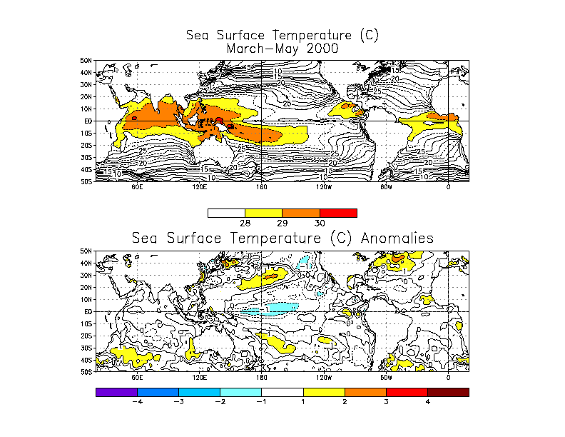
The long-lived tropical Pacific cold episode (La
Niña) weakened in March-May 2000, but persisted through the season. Sea-surface
temperature (SST) indices for the tropical Pacific were near zero in the east
Pacific and only slightly negative in the central Pacific. Seasonal
average SST anomalies show continued but weakened La Niña conditions, compared to the
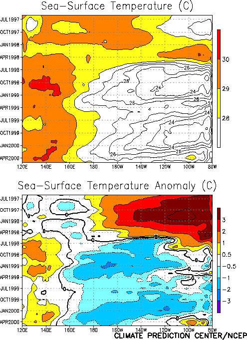
previous season. The time-longitude
plot of equatorial SSTs shows a double peak in the La Niña episode, first in late
1998 to early 1999 and again in late 1999 to early 2000. La Niña episodes that last two
or more years are less common than shorter episodes, particularly for strong cold
episodes, but they have occurred in the historical record. The previous last strong
double-peak La Niña had extremes in 1973-74 and 1975-76. A weak extended cold episode
also occurred in 1984–85. Cold episodes that last for three or more years have also
been observed in the historical record. For example, cold episode conditions began in 1906
and persisted until 1911, with extremes in 1909 and early 1910. There were also weak
negative anomalies in the equatorial Pacific for much of the period between 1942 and 1950,
with extremes in late 1942 through early 1943 and again in early 1950. In those earlier
extended episodes, the cold episode conditions were weak for most of the extended episode.
There are no strong triple-peak cold episodes in the historical record.
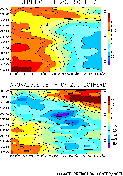
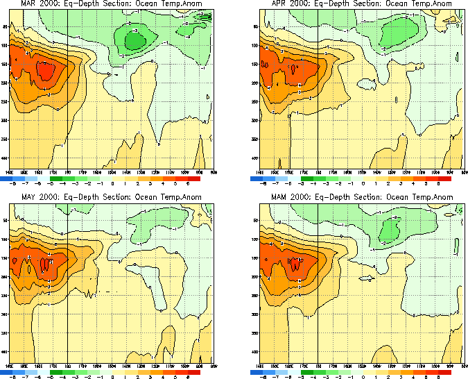
The depth
of the 20°C isotherm indicates that over the past two years, heat storage has been
building in the western tropical Pacific, and by May 2000 positive subsurface temperature anomalies had begun to spread to the
eastern-equatorial Pacific. Evolution and maintenance of La Niña depends on several
factors besides subsurface temperatures, including atmospheric feedbacks affecting the
strength of the easterly surface winds along the equatorial Pacific. However, the
subsurface temperature anomalies are often the first sign of changes at the surface in the
east-tropical Pacific because subsurface equatorial waters are typically brought to the
surface (upwelled) by the winds in the equatorial Pacific. Warming of the subsurface
eastern-equatorial Pacific limits the ability of a cold episode to re-establish itself,
since any upwelled waters will be relatively warm.
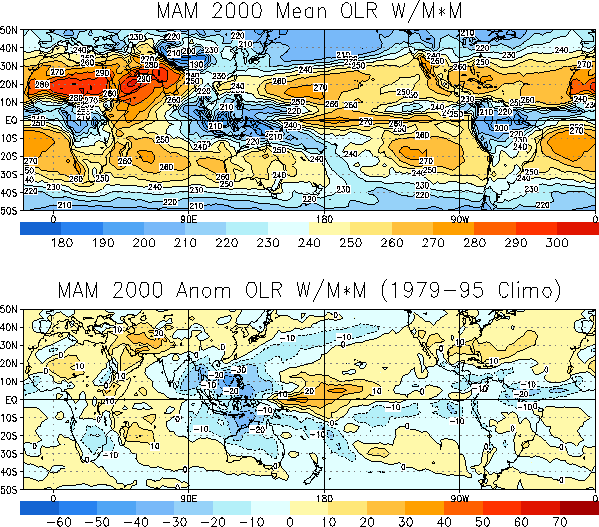
Outgoing longwave radiation (OLR) anomalies for March-May
2000 indicate suppressed convection in the tropical Pacific near the date line, and
enhanced convection over Indonesia, consistent with cold-episode conditions. However,
there was also enhanced convection over parts of the eastern Pacific late in the season,
reflecting positive SST anomalies in that region. The OLR anomalies also indicate
suppressed convection in east-equatorial Africa and enhanced convection over northeast
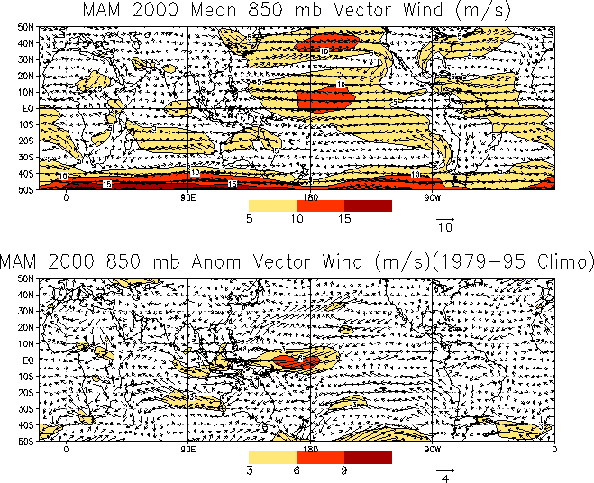
South America. The 850 mb wind anomalies show enhanced
easterly winds in the central to western equatorial Pacific, over the region where
negative SST anomalies persisted during the season. The strength of the easterly anomalies
decreased over the season, and wind anomalies in the eastern-equatorial Pacific were weak
or slightly westerly, reflecting the weakening cold-episode conditions. Late in the season
strong west-southwest 850 hPa wind anomalies developed over the northwest Indian Ocean,
suggesting an early onset of the Indian monsoon season.
For the contiguous United States, temperatures during the
March-May season averaged above normal across the entire country, with the largest
anomalies (more than 2°C above normal) observed over the Southwest and parts of the
north-central region. On a monthly basis the largest anomalies occurred during March, with
temperatures 3°-5°C above normal observed across parts of the Northeast, the Midwest and
the Northern Plains. During April, much of the eastern half of the nation experienced
slightly below-normal temperatures, with positive anomalies (up to +3°C) recorded over
the Rocky Mountains, the Southwest, and along the West Coast. Temperatures were again
above-normal from coast-to-coast during May, with the largest anomalies again observed
over the Southwest.
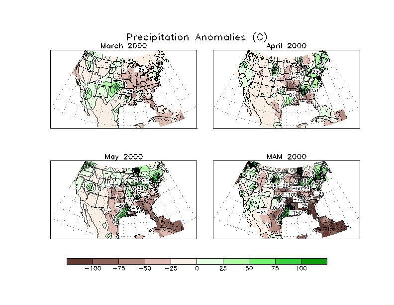
Precipitation across the United States during the season
featured above normal rainfall across the mid-Atlantic, the Northeast and the Great Lakes,
and a continuation of drier-than-normal conditions in the Midwest and the Southeast.
Rainfall was below normal across Florida and much of the Southeast during all three
months, with deficits of more the 75 mm observed across much of this region during May and
seasonal deficits of over 150 mm observed across Alabama and Georgia. Dryness along the
Gulf Coast (Louisiana to Florida) and in the Midwest was a continuation of dry conditions
that had persisted since 1999. In contrast, the above-normal rainfall in the Great Lakes
region ended a prolonged period of below-normal rainfall that had also persisted from the
previous year.
Global temperature anomalies for the season show that
most of the Northern Hemisphere was warmer than usual, with largest anomalies in North
America, Europe, and Siberia. Towards the end of the season the positive anomalies
weakened and negative anomalies developed in northwest North America and western Russia.
In the Southern Hemisphere the seasonal anomalies were on average positive, but much
weaker than in the Northern Hemisphere. The largest positive Southern Hemisphere
temperature anomalies were over the South Pacific and Indian Oceans. Temperatures over
Australia were much below normal throughout the season, which was a continuation from the
previous season. Late in the season negative anomalies also developed over South
Africa. The global-average temperature for the season was slightly above normal, but was
smaller than in the previous season.
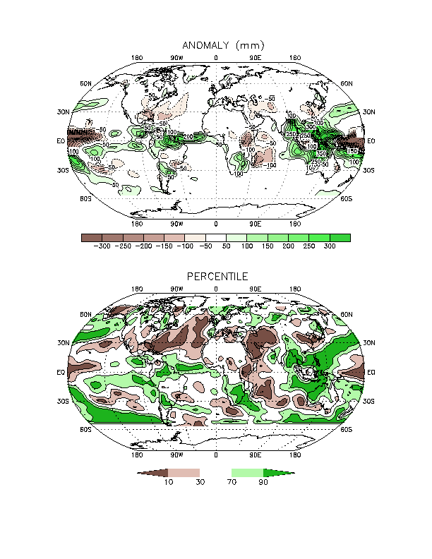
Global precipitation anomalies for the season were
dominated by La Niña impacts. Precipitation was enhanced over Indonesia and suppressed
over the central tropical Pacific. The Indian monsoon developed a little early, which
resulted in a wetter-than-normal March-May season. Precipitation was greater than normal
in a band extending from northeastern South America into the Atlantic. Early in the season
southeast Africa was wetter than normal, but precipitation amounts were normal over the
region late in the season.
|


