|
Latest Seasonal Assessment -
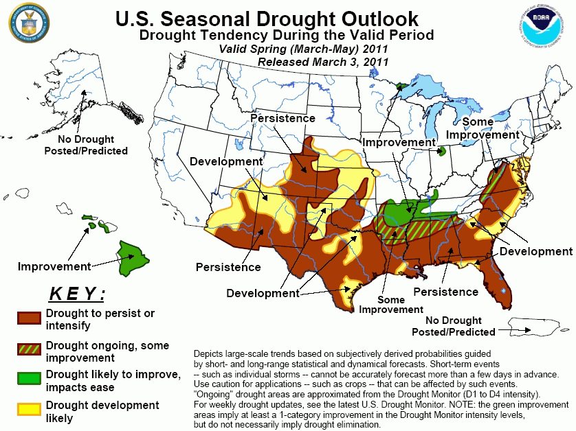
The updated drought outlook for Spring (March–May) 2011, completed by March 3, was based largely upon climate
anomalies associated with an ongoing, mature La Niña that has begun to weaken, with ENSO-neutral or La Niña
conditions equally likely by May-June. The CPC monthly and seasonal outlooks indicated enhanced odds for below
median precipitation and above median temperatures across the southern tier of the Nation which favors drought
persistence from southern Arizona eastward into the southern Plains, along the Gulf Coast States, and northward
along the Carolina Coasts. The CPC seasonal precipitation outlook also has increased odds of subnormal totals in
the central High Plains. Therefore, drought development is forecast across the rest of the southern U.S., from
southwestern Arizona eastward into the southern and central Plains, northern and southeastern Texas, and along
parts of the Gulf and southern and middle Atlantic Coasts. Although there were some concerns in the Northwest
that spring drought development was possible after a mild and very dry January, a good start to their wet season
plus recent storms and enhanced odds of above median March precipitation suppressed any notion of spring drought
development. Recent heavy rains that caused some flooding have already improved conditions or eliminated drought
in the Ohio and Tennessee Valleys, while prospects for further improvement are indicated in the Tennessee and
lower Mississippi Valleys. Some improvement is predicted for the Arklatex region, northern Mississippi, Alabama,
and Georgia, and the Appalachians. This is based upon short- and medium-term forecasts of heavy rains, enhanced
odds for above normal monthly precipitation, and some hints of wetness in the La Niña MAM composite and trend
although the frequency of occurrence is low. Drought relief has occurred in Hawaii this winter, courtesy of
heavy rainfall associated with La Niña. Although moderate drought (D1) was recently added to the eastern Big
Island, continued improvement is forecast for the islands remaining in drought.
|
|
Tools used in the U.S. Drought Outlook (USDO)
included the official CPC precipitation outlook for March 2011
and the long lead forecast for March - May 2011, various medium- and short-range forecasts and
models such as the 6-10 day and 8-14 day forecasts, the soil moisture
tools based on the GFS model and the Constructed Analogue on Soil (CAS) moisture, the Climate Forecast
System (CFS) seasonal precipitation forecasts, La Niña composites for the March - May season, the four-month
Palmer drought termination and amelioration probabilities, climatology, and initial conditions.
A very dry and cold December and
January, along with spotty February precipitation and above-normal temperatures, has resulted in expanding
drought across most of the middle and southern Atlantic States. Many USGS stream flows from western South
Carolina northward into central Virginia have fallen below the 10th percentile (much below normal). An
exception to this was in northern Florida, southern Georgia, and coastal Carolinas where late January and
February moderate to heavy rains improved drought conditions and increased stream flows to near and above
normal values. In contrast, USGS river flows in north-central Florida, still suffering from long-term drought
deficiencies, remained at or below the 25th percentile. Since La Niña MAM precipitation composites and the
CPC monthly and seasonal outlooks strongly favor enhanced odds for below median precipitation in the southern
Atlantic States, drought is expected to persist or develop across Florida, Georgia, and South Carolina. In
the mid-Atlantic (North Carolina to Maryland), the odds for subnormal monthly and seasonal precipitation
gradually decrease in the outlooks as one heads north (e.g. become equal chances), and actually tilt toward
above median monthly precipitation further to the west (e.g. central Appalachians). And in the short to
medium-terms, heavy precipitation is forecast for the western and northern mid-Atlantic. In contrast, the La
Niña MAM precipitation composites hint at dryness along the coast while lingering effects from last summer's
drought point toward persistence and development.
Forecast confidence for southern Atlantic States are moderate to high;
Forecast confidence for middle Atlantic States are low to moderate.
Across the Southeast, La Niña MAM
composites indicate the highest negative precipitation anomalies along the central and eastern Gulf Coast,
from southern Louisiana eastward to northeast Florida. The CPC updated monthly outlook indicates the highest
odds for below median precipitation along the western and eastern parts of the Gulf Coast, and lower odds
along the central Gulf. The CPC seasonal outlook has the greatest odds for subnormal precipitation along the
eastern half of the Gulf. Subnormal precipitation odds in both the monthly and seasonal outlooks quickly
decrease to equal chances as one heads north, and actually transition to above median precipitation for March
in Tennessee and areas northward. Therefore, drought is expected to persist or develop across most of the
Southeast, except in northern sections of Mississippi, Alabama, and Georgia where initial conditions are
wetter and the monthly outlook favors near to above median precipitation. Due to the weak and mixed signals
among the precipitation tools beyond late February, some improvement is forecast across those northern areas
of Mississippi, Alabama, and Georgia.
Forecast confidence for the immediate Gulf Coast States are high;
Forecast confidence for the remainder of the Southeast is moderate.
From mid-November into late
January, northwesterly flow, attributed to a strong and persistent negative Arctic Oscillation/North Atlantic
Oscillation (upper-air blocking pattern), resulted in abnormally cold and dry conditions across the lower
Ohio, Tennessee, and middle Mississippi Valleys. This in turn caused a slight expansion of moderate drought
and abnormal dryness in northern Arkansas, southern Missouri, and southern Illinois. Furthermore, the
persistent and strong AO/NOA suppressed the expected winter surplus precipitation that normally occurs in the
Ohio and Tennessee Valleys during a La Niña. But with the AO/NAO near zero or positive for much of February,
above-normal precipitation returned to the Tennessee and Ohio Valleys, easing drought and even causing some
flooding. Furthermore, with the AO/NAO a non-factor and less influential during spring, the CPC monthly
outlook favors continued above median precipitation across the Tennessee and Ohio Valleys. In the lower
Mississippi Valley, the seasonal La Niña MAM composites also point toward above normal precipitation,
although the frequency is rather low. In addition, the seasonal CPC outlook has equal chances. And as already
mentioned, most forecast tools and the CPC outlooks favor enhanced odds of below normal precipitation as one
nears the Gulf Coast. Accordingly, improvement is forecast in the Ohio, Tennessee, and lower Mississippi
Valleys, while some improvement is expected for the rest of Arkansas.
Forecast confidence for the Ohio and Tennessee Valleys are high;
Forecast confidence for lower Mississippi Valley is moderate to high.
In most of Texas, near to above
normal precipitation fell from late December into early February, resulting in a reduction of drought
coverage and severity across southern, southeastern, and eastern sections of the state. In the Panhandle,
surplus fall precipitation had carried the region into the winter without any drought impacts. However,
since early February, drier, warmer, and windy weather has deteriorated conditions across much of the State,
with moderate (D1) or worse drought now enveloping much of Texas. The CPC monthly and seasonal outlooks both
call for enhanced odds of above-normal temperatures, with the seasonal precipitation outlook odds for dryness
somewhat less than the monthly outlook. Due to these relatively dry and warm forecasts, drought is expected
to continue (or worsen), and return to northern and southern Texas.
Forecast confidence for Texas is high.
Following a very dry January,
above-normal February precipitation fell on parts of the south-central Great and central High Plains, but
missed most of the main drought areas. Some improvement is forecast in eastern Oklahoma where February was
wet and the La Niña MAM composites indicate above-normal precipitation (but with a low frequency of
occurrence). Elsewhere in the central Plains, precipitation tools at most time ranges indicate an elevated
chance for below median precipitation, especially the La Niña MAM composite which has a high frequency
occurrence. Just to the north, however, forecast tools point toward wetness and subnormal temperatures, plus
soil moistures are extremely high (above 90th percentile). This limits any northward drought expansion due to
existing moisture conditions. In addition, short- to medium-term forecasts expect ample precipitation in the
north-central Plains. Accordingly, the persistence and development areas issued in the initial MAM 2011 USDO
(February 17) were kept, while the area of development in the central Great Plains was slightly trimmed back
in line with the short and medium-term forecasts, and the monthly and seasonal outlooks.
Forecast confidence for the south-central and central Plains are moderate to high.
Since mid-December, drier than
normal conditions have affected much of Arizona and New Mexico. As of March 1, SNOTEL average river basin
snow water content values are 35 to 75 percent of normal in southern and central Arizona and New Mexico,
with basin average precipitation since October 1 running at about the same values (31 to 76 percent of normal).
Precipitation tools at all time ranges indicate enhanced odds of below median precipitation and above normal
temperatures. Due to a lack of adequate precipitation this winter, a tendency for dryness during La Niña,
forecasts of below median precipitation and above normal temperatures, and decreasing precipitation
climatologies for areas already in drought, drought persistence and development can be expected across much
of Arizona and New Mexico, and into southeastern Utah and southwestern Colorado. However, expansion is not
forecast for southern California as many locations have already exceeded their normal winter precipitation
and approached their normal ANNUAL totals from December's excessive precipitation. Furthermore, another bout
of moderate to heavy precipitation during the latter half of February reinforced that prediction.
Forecast confidence for the Southwest is high.
During the 2010-11 winter, heavy
rainfall alleviated drought and dryness on Kauai and Oahu and diminished drought conditions across most of
the rest of the central and western Hawaiian Islands which is typical for a La Niña winter. An exception
occurred on the Big Island where subnormal rainfall during January and February brought moderate drought (D1)
to eastern areas by March 1. However, the ongoing La Niña favors additional improvement in Hawaii by the end
of May, including the Big Island.
Forecast confidence for Hawaii is moderate to high.
|


