|
Latest Monthly Assessment -
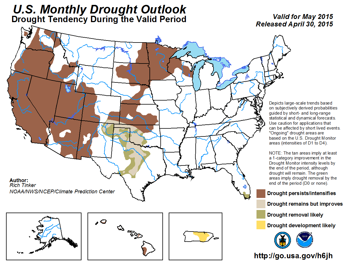
Drought is expected to persist through May where it exists from the Rockies westward to the Pacific Ocean, with some areas of
intensification possible. Confidence is particularly high in California and, to a lesser extent, other parts of the Southwest and
West Coast, where mid- to late spring is one of the drier times of the year. In contrast, drought removal is likely in south
Florida, where rainfall is increasing climatologically, and forecasts on most time scales favor wetter than normal weather. In
between these two regions, the outlook for the Plains states and western Great Lakes region is less certain. May is one of the
wetter months in most of the region, generally bringing 10 to 20 percent of annual rainfall. In addition, outlooks for at least the
first half of the month lean wet throughout the region. But one month of above-normal precipitation during one of the wetter times
of year is not necessarily enough to bring substantial drought relief. Improvement and removal seem most likely in the southern
Plains, where there has been a wet pattern recently, forecasts for early May have consistently indicated moderate to heavy rain,
and the May Monthly Outlook calls for enchanced chances of above-normal rainfall. Farther north, improvement seems less likely,
with less consistent indications of heavy precipitation through mid-May across the north-central Great Plains. Since the revised
monthly outlook indicates a tilt in the odds towards below-median precipitaiton across the Upper Mississippi Valley, persistence is
favored for this region. Persistence is most likely for In Hawaii, the odds somewhat favor wetter than normal, but this is a
relatively dry time of year, so no change in drought conditions is anticipated. It should be noted that abnormally dry conditions
cover parts of the Northeast, and should May start out drier than normal, some areas of drought could develop. However, odds do not
favor significantly less precipitation than normal, and no development is forecast at this time. In Puerto Rico, current D0 areas in
eastern sections, along with recent dry and hot weather and odds tilted toward subnormal May rainfall (delayed start to summer
rains), point toward development of drought (D1).
|
|
Tools used in the U.S. Monthly Drought Outlook (MDO) included the official Climate Prediction Center (CPC)
updated temperature and precipitation outlooks for May 2015, various short- and medium-range forecasts and models such as
the 7-day precipitation totals from the Weather Prediction Center (WPC), the 6-10 day and 8-14 day CPC forecasts, week 3 and
4 experimental outlooks, the NAEFS precipitation outlooks, dynamical models (CFSv2), the 384-hour total precipitation
forecasts from several runs of the GFS, climatology, the latest official Drought Monitor analysis (released on April 30),
observed precipitation during the previous month, and initial conditions.
Drought removal is likely by the end of May in southern Florida. Forecasts on all time scales favor wetter than normal
weather, and climatologically rainfall increases during the month.
Forecast confidence for southern Florida is high.
In the western Great Lakes region and the central and northern Plains (from roughly the Oklahoma/Kansas border northward),
drought is forecast to persist or intensify, but confidence is low. May is one of the wettest times of the year in this
region, bringing 10 to 20 percent of the annual precipitation total on average. However, there is uncertainty in the extent
and location of the heavier precipitation expected early in the month, and given the current conditions, precipitation would
need to be substantially above normal for a 2- to 4-week period before any significant relief would occur. Also, rainfall is
convective in nature this time of year. Some localized or regional areas will likely see rainfall heavy enough to provide
some relief, but since convective rainfall is hit-and-miss by nature, and because forecasts have been inconsistent in their
depictions of the location, amount, and extent of heavier rains, we expect drought persistence or intensification will
prevail, with small areas of improvement or removal occurring in the limited regions where precipitation is the heaviest.
Altogether, these conflicting indicators make for a low confidence forecast.
Forecast confidence for the northern and central Plains and the western Great Lakes Region is low.
The southern Plains present similar issues to those observed farther north in the previous paragraph, but the tools indicating
heavy rain for the first half of May have been more consistent, widespread, and robust. This is also a wet time of the year in
the region, though not so markedly as farther to the north. Another consideration is that wet weather has already been
observed for the past few weeks or so, and it should not take as much additional precipitation to bring improvement or
removal as it would farther north, where the short-term has been drier. For all these reasons, improvement or removal is
expected, but once again it should be noted that rainfall is convective in nature this time of year, and there will probably
be areas that miss out on the heavier rainfall, and in these areas drought will persist. But improvement or removal should
cover a significant majority of the region. Still, the above considerations result in increased forecast uncertainty.
Forecast confidence for the southern Plains is low.
Drought now covers most areas from the central and southern Rockies westward through California and into the Pacific Northwest.
May is one of the warmer and drier months of the year climatologically, especially in the Southwest and across southern and
western sections of California, where May on average provides less than 4 percent of the annual rainfall total. Drought should
persist throughout this large area for climatological reasons, even in areas where above-normal May rainfall seems likely.
Forecast confidence for Rockies and Far West is high.
Drought is expected to persist where it exists across Hawaii. Odds favor above-normal May rainfall across much of the island
chain, but this is one of the drier times of the year across the state, and amounts are not expected to be sufficient for any
significant drought relief, though the forecast introduces some degree of uncertainty.
Forecast confidence for Hawaii is moderate.
Dry and warmer-than-normal conditions have prevailed recently across Puerto Rico, with April rainfall less than half of normal
in many areas. Many locations are reporting streamflows among the lowest 10 percent of historic measurements for this time of
year. Most (though not all) tools point toward drier than normal conditions continuing through May. As a result, drought is
expected to develop by the end of the month in areas currently assessed as abnormally dry (D0) on the Drought Monitor.
Forecast confidence for Puerto Rico is moderate to high.
|


