|
Latest Monthly Assessment -
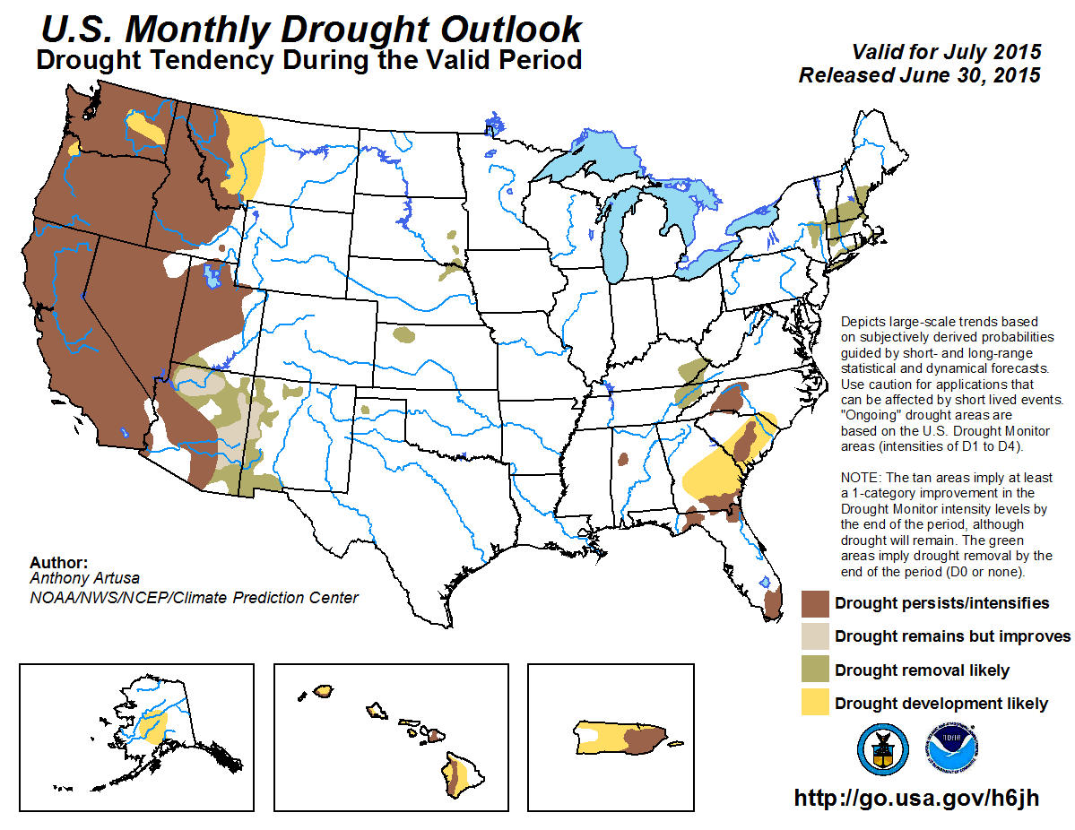
During the past 14-days, above-average rainfall amounts were reported along a curved path from eastern Texas north-northeastward
into the central Mississippi Valley, and continuing eastward across the Ohio and Tennessee Valleys, central Appalachians, and
mid-Atlantic region. Above- average rainfall amounts were also observed across portions of the northern Great Plains, New Mexico,
the upper Mississippi Valley, New York, and much of New England. Relatively hot, dry conditions are expected to persist across the
Pacific Northwest, the northern Rockies, and parts of California. Drought is therefore anticipated to persist and/or intensify in
this region, while several areas of drought development have also been introduced, most notably in west-central Montana. The
Southwest Monsoon season has already started in some areas of the desert Southwest (such as Tucson, AZ) and is predicted to bring
about a one-category improvement in drought conditions across New Mexico, and northern and eastern Arizona during the month of July.
For some areas, a one-category improvement equates to the removal of drought. Across the Plains, upper Ohio and Tennessee Valleys,
and the Northeast, passing frontal systems are forecast to bring an end to current drought conditions. Nighttime thunderstorm
clusters, which are generally responsible for about 40-50 percent of the warm season precipitation across the Nation's Heartland,
are also expected to contribute to drought removal across the Plains. In the Southeast, above-normal temperatures, deteriorating
soil moisture conditions, increased evapotranspiration, and increased demand upon available water supplies, are all likely to make
it difficult to obtain any significant drought relief during July. Persistence/Intensification of current drought is favored across
the Southeast, while development of additional drought is indicated for portions of the southern Atlantic Coastal Plain. Drought
development is anticipated across the leeward slopes of the Hawaiian Islands, from central portions of the Alaskan interior to the
Anchorage/MatSu Valley region, and much of Puerto Rico, in response to model predictions of below-median rainfall amounts in those
areas.
|
|
Tools used in the U.S. Monthly Drought Outlook (MDO) included the official Climate Prediction Center
(CPC) updated temperature and precipitation outlooks for July 2015, various short- and medium-range forecasts
and models such as the 7-day precipitation totals from the Weather Prediction Center (WPC), the 6-10 day and 8-14 day CPC
forecasts, week 3 and 4 experimental outlooks, the NAEFS precipitation outlooks, dynamical models (CFSv2), the 384-hour
total precipitation forecasts from several runs of the GFS, climatology, the latest official U.S. Drought Monitor analysis
(released on June 25), observed precipitation during the previous month, and initial conditions.
During the last 30-days, precipitation has been above-average across most of the Northeast, with only very spotty areas
of below-average rainfall noted along the southern New England coast, eastern Long Island, and extreme northern Maine.
Near to above-average rainfall is expected across this region during the extended-range period (days 6-14), though there
is no clear tilt in the odds for the updated July 2015 precipitation outlook. Passing frontal systems are anticipated to
bring about the removal of residual drought in the Northeast during July.
Forecast confidence in the Northeast is moderate.
In the Southeast, several areas of drought remain in southern Georgia, the Florida Panhandle and far southern Florida,
northwest Alabama, and parts of the Carolinas. Rainfall deficits are especially noticeable in far southern Florida,
where the Advanced Hydrologic Prediction Service (AHPS) indicates rainfall departures ranging from 4-5 inches
below-average during the past 30-days, with some localized spots experiencing even larger deficits. The expectation of
continued hot weather, increasing soil moisture deficits, elevated evapotranspiration rates, and the increased demand on
available water supplies all favor persistence and/or intensification of these drought areas, with additional drought
development anticipated over portions of the southern Atlantic Coastal Plain. Across far southern Florida, the main
consideration is the diurnal westward shift of the sea-breeze convergence zone, which is largely dependent upon the
strength of the easterly trade winds. The dynamic nature of the sea-breeze convergence zone determines where heavy
tropical showers and thunderstorm activity is likely to be focused, though the specific details are very difficult
to pin down. Most dynamical guidance favors the persistence/intensification of drought in this area.
Forecast confidence for the Southeast is generally moderate, but low for southern Florida.
Current drought in parts of Kentucky and Tennessee is forecast to be short-lived. Within the next 7-days, 4-5 inches of
rain is predicted to fall. Near to above-average rainfall is favored during the extended-range period, and there is
fairly high confidence for above-median rainfall in the updated precipitation outlook for July. At any rate, the
front-loaded precipitation signal (4-5 inches early in the month) should be more than adequate to remove the current
drought area in eastern Kentucky and eastern Tennessee.
Forecast confidence is moderate to high across the Ohio and Tennessee Valleys.
Only a few small pockets of drought remain over the Great Plains. The precipitation outlooks for the next few weeks
support the removal of these lingering, spotty, drought areas, as does CPC's July temperature and precipitation outlooks,
which favor abnormally cool, wet conditions. As is common for the Plains during the warm season, most rainfall comes from
passing frontal systems and nighttime thunderstorm clusters (MCS).
Forecast confidence in the Plains is moderate to high.
For the Southwest and parts of southern California, rainfall at this time of year tends to come from the Summer Monsoon,
with climatological onset around the start of July. However, the monsoon officially started about a week early this year
in Tucson, Arizona (June 25th). Historical records show that, despite an early onset in southern and southeastern
Arizona, there is a strong likelihood for that area to receive below-average monsoon rainfall for the season. Granted,
this monthly drought outlook only covers July, and not the entire monsoon season. In the next 7-days, up to several
inches of rain are predicted for parts of Arizona and New Mexico. The extended-range outlooks (for days 6-14) call for
elevated odds of above-average precipitation across the Southwest, with the highest probabilities in New Mexico and
eastern Arizona. CPC's updated precipitation outlook for July favors above-average rainfall in New Mexico, the
northeastern half of Arizona, Utah, and Nevada, with Equal Chances (EC) of below-, near-, and above-average precipitation
for the southwestern half of Arizona, and all of California. The Climate Forecast System (CFS) precipitation forecasts
produced during the past nine days clearly predict upper-tercile (above-average) precipitation across the Southwest
(including most of California) during the month of July. It is important to note, however, that CPC's official
precipitation outlook for July favors EC for California, and not above-average rainfall. The suppressed convective phase
of the Madden-Julian Oscillation (MJO), and increased vertical wind shear, is expected to be unfavorable for tropical
cyclone development across the far eastern tropical Pacific for the first week to ten days of July. Beyond that time,
the enhanced convective phase and reduced vertical wind shear are more likely over the eastern Pacific. Occasionally,
moisture associated with these tropical storms and hurricanes can make its way across Baja California and into the
Southwest. After viewing various models and tools for the Southwest, it was reasoned that the most likely areas to
receive either drought improvement or removal are western New Mexico, and both northern and eastern Arizona.
Forecast confidence in the Southwest is low to moderate.
For the northern Rockies and the Pacific Northwest, upper-level ridging and very hot weather has recently prevailed.
This past weekend, there were numerous reports of high temperature records (even if by only one degree F). A few selected
high temperature records include 113F at Walla Walla, WA, (which exceeded the all-time, statewide June record of 112F set
at John Day Dam on June 18, 1961); the Boise Airport topped out at 110F (hottest temperature ever reported in June, and
just 1 degree F shy of their all-time record of 111F); and Pendleton, OR, which hit 109F on both days of the weekend,
breaking their previous all-time record June high of 108F set back in 1924 and 1961. Even high minimum temperature
records were established in this region. Medford, OR, for example, recorded their highest minimum temperature (since
record-keeping began in 1911) of 76 degrees F on June 28th. Extended-range forecasts favor elevated odds of continuing
above-normal temperatures and below-median rainfall across the region. CPC's updated temperature and precipitation
outlooks for July call for high probabilities of above-normal temperature for the Pacific Northwest and northern Rockies,
and below-median rainfall (Washington state and northwest Oregon), and primarily EC elsewhere. Drought is therefore
expected to either persist or intensify during July, with several areas of drought development anticipated. Drought
development is also indicated over west-central Montana, which has generally received anywhere from 10-50 percent of
normal rainfall over the past 30-days. The National Weather Service in Great Falls, for example, reports only 0.44-inch
of precipitation for the month of June so far (data through the 29th), which is 2.03 inches below average.
Forecast confidence in the northern Rockies and Pacific Northwest is moderate to high.
For Hawaii, there is a tendency toward wetter conditions during El Niño summers. Trade winds occurring about 90
percent of the time favor the windward (generally east-facing) slopes of the Islands getting sufficient rainfall. This
also favors developing dryness/drought for the leeward (generally west-facing) slopes.
Forecast confidence in Hawaii is moderate.
Dry conditions have recently prevailed across portions of the central Interior of Alaska. Precipitation outlooks
throughout the next 30-days predict a continuation of below-median precipitation. Accordingly, drought development was
introduced from the Anchorage/Mat-Su Valley area northward into the central Interior.
Forecast confidence in Alaska is moderate.
Suppressed convection across much of Puerto Rico has resulted in deteriorating conditions. Climate anomalies associated
with El Niño strongly favor suppressed convection and reduced tropical cyclone activity across the Caribbean, and
this signal is supported by the latest dynamical model guidance. Therefore, drought is expected to expand/develop across
most of the remainder of the Island. The one exception seems to be the northwest, which continues to receive beneficial
rain, despite the entrenched persistence and intensification of drought elsewhere on the island.
Forecast confidence in Puerto Rico is moderate to high.
|


