|
| |
 |
| |
|
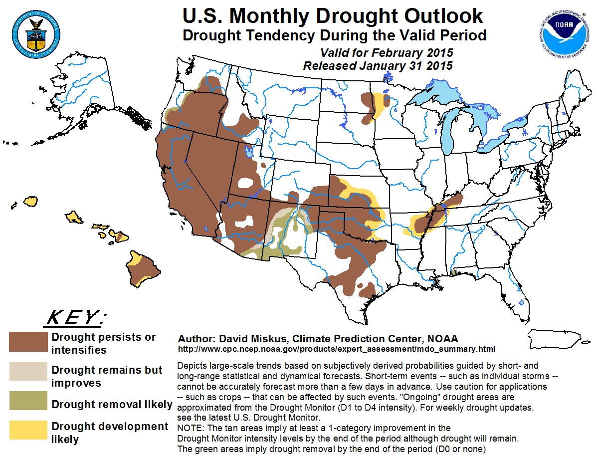
February 2015
|
| |
|
Outlook Graphic: PNG PDF 
|
| |
|
Latest Monthly Assessment -
During the past 2 weeks since the release of the latest Seasonal Drought Outlook (Jan. 15), drought improvement was limited to
parts of the interior Northwest, along portions of the central Gulf Coast, and in parts of south-central Texas. A developing
storm in the Southwest was bringing welcome moisture to that region as of late January. The very dry January, however,
continued across much of California, negating the Water Year-to-Date surpluses most of the state had gained during a wet
December. Subnormal January precipitation was also present in the upper Midwest, central Plains, Tennessee Valley, interior
Northeast, and parts of the Southeast, especially south Florida. As a result, abnormal dryness or drought was found in the
much of the West and Southwest, the southern and northern Plains, portions of the Midwest, the Tennessee Valley, in parts of
the interior Northeast and Southeast, across Hawaii, and in south-central Puerto Rico. The El Niño watch continued with a 50
to 60 percent chance of El Niño conditions during the next 2 months, and ENSO-neutral favored thereafter.
Precipitation during the winter months (Dec-Feb) are crucial to recharging moisture and building mountain snow packs for
spring and summer snow melts in the West. With that said, precipitation during February becomes even more critical when the
prior two months combined fail to deliver normal amounts. This is especially true in California as a very wet start to
December halted after the 20th, with near to record dryness continuing throughout January, effectively negating the surplus
December precipitation and dropping the Water Year to Date precipitation to below normal. Unfortunately, the general pattern
for the Southwest (once the current Southwest storm treks eastward) is for above-normal temperatures and below-median
precipitation - which is no help for the California drought. Instead, a series of Pacific storms should bring above-median
chances of precipitation to the Pacific Northwest and as far south as extreme northwestern California. However, temperatures
should average above normal which would tend for the precipitation to fall as rain instead of snow except on the highest
elevations of the Cascades and Sierra Nevada. In contrast, recent wetness, the current storm, possible late February
precipitation (weeks 3 and 4), and less severe drought conditions may allow parts of New Mexico to improve by the end of the
month.
In the Nation's mid-section, February is climatologically dry, so with short and medium-term forecasts favoring near or
sub-median precipitation and no odds either way in the updated February precipitation outlook, persistence is likely. Some
development (expansion), however, is possible in areas where the largest short-term deficits have accumulated (western
Minnesota, central Kansas, and eastern Oklahoma). To the east, similar conditions in the Tennessee Valley could also allow for
expansion of drought into eastern Arkansas and western Tennessee with subnormal precipitation anticipated for the next
3 weeks.
In the South and East, widespread moderate precipitation during early February, anticipated subnormal February temperatures,
enhanced odds for above-median monthly precipitation in the Southeast, and recent wetness along the Gulf and Atlantic Coasts
should remove drought along the central Gulf Coast and prevent any development of drought in the eastern quarter of the
Nation.
The odds favor continued February (and winter) dryness in Hawaii. Drought will persist on parts of Maui and Molokai and most
of the Big Island, and expand across the rest of the islands where abnormal dryness (D0) existed at the end of January. No
drought is anticipated in Alaska or Puerto Rico.
|
| |
|
Discussion for the Monthly Drought Outlook
|
| |
|
Tools used in the U.S. Monthly Drought Outlook (MDO) included the official Climate Prediction Center (CPC) updated
temperature and precipitation outlooks for February 2015, various short- and medium-range forecasts and models such as
the 7-day precipitation totals from the Weather Prediction Center (WPC), the 6-10 day and 8-14 day CPC forecasts, week 3
and 4 experimental outlooks, the NAEFS precipitation outlooks, dynamical models (CFSv2), the 384-hour total precipitation
forecasts from several runs of the GFS, climatology, the latest official Drought Monitor analysis (valid on January 27),
observed precipitation during the previous month, and initial conditions.
During early February, the recent pattern of near to above-normal precipitation for the Gulf Coast and Southeast is
expected to continue, allowing for possible improvement of remnant drought (D1) along the central Gulf Coast. Although
week 1 and 2 outlooks across the eastern third of the Nation have odds tilted toward near or subnormal precipitation
(except in Florida), the updated February outlook has a good chance for above median precipitation in the eastern Gulf
and southern Atlantic region. This, combined with expected subnormal February temperatures and recent wetness, should be
enough to prevent any development of drought through February in the Southeast and Northeast. An exception would be in
the western Tennessee Valley where recent dryness has accumulated January deficits of 2 to 4 inches, leading to some
possible D1 expansion. In addition, although southern Florida has seen less than half of normal precipitation the past
90 days and only a quarter of normal the last 60 days, increased chances for rainfall during February should halt any
drought development.
Confidence in the forecast along the central Gulf Coast and Tennessee Valley is moderate.
In the northern Plains and upper Midwest, although the winter months are climatologically dry and the ground is usually
frozen until the spring, the lack of snow cover (and precipitation) has been a concern. With short and medium-term
forecasts predicting minimal precipitation, persistence is a good bet here, along with possible slight drought expansion
(development) near the existing D1 areas where precipitation has been lowest during the past 60- to 90-days
(western Minnesota).
Confidence in the forecast in the upper Midwest and northern Plains is moderate.
To the south, February is also climatologically dry in the central and southern High Plains (but a bit wetter in the
southern Great Plains). Even so, January has been quite dry in the central Plains with very little precipitation, and
recent mild conditions have degraded topsoil moisture there. Although light precipitation is expected the next few days,
week 1 and 2 forecasts favor sub-median precipitation (February temperature and precipitation is EC - no tilt), hence the
expansion of drought in Kansas and eastern Oklahoma, and persistence elsewhere. In Texas, recent wetness has allowed for
some improvements to the state, and the current storm promises light to moderate amounts over the next few days. Later in
February, however, medium-range forecasts depict sub-median precipitation that negate continued improvement, hence
persistence for the state.
Confidence in the forecast in the central Plains is moderate; low to moderate in the southern Plains.
In the Southwest, stormy weather will usher January out and February in, increasing currently low snow packs in Arizona,
southern Utah, New Mexico, and southern Colorado. After this storm passes, however, drier and milder conditions are
predicted for weeks 1 and 2. The updated February precipitation outlook has no tilt either way, although some week 3 and
4 outlooks have a hint of wetness in New Mexico albeit with low confidence. With the recent wetness in New Mexico, the
current storm, and overall less severe drought conditions, some spotty improvement is possible in New Mexico and
southeastern Arizona during February. Since it has been drier during January to the west and north, persistence is
maintained in the rest of Arizona, southern Utah, and southern Colorado.
Confidence in the forecast across the Southwest is low (w/r to improvement) to moderate (w/r to persistence).
In the West, a near to record dry January has negated the excess precipitation from a wet December in California as the
Water Year-to-Date (since Oct. 1) precipitation is now below normal for much of the state. With the dry January, this
leaves February and March to provide drought improvement as California's wet season winds down during the spring months.
Unfortunately, the first 3 weeks of February are not optimistic for most of California as little or no precipitation is
expected during the first week, and the odds favor sub-median amounts during weeks 1 and 2. The best chances for
significant precipitation were found in the Pacific Northwest (southward into northwestern California) where short-term
(7-days), weeks 1 and 2, and the updated February outlooks all have favorable odds for above-median precipitation. This
was depicted by a slight reduction of drought along the western edge in the Northwest. Farther inland, however, lower
totals and odds, along with low snow water content in the Cascades, maintain the drought there. Considering the
entrenched multi-year nature of the drought in California, a dry January that negated wetness during December, very low
snow water content in the Sierra Nevada (less than 25 percent of normal), and still below normal major reservoir
capacities, this will most-likely be the 4th consecutive winter with subnormal precipitation across California.
Confidence in the forecast across the West is moderate (Pacific Northwest) to high (California).
The odds favor drier than normal weather in Hawaii during February and for the winter as a whole. Climatologically,
rainfall is highest during the winter months in Maui and Molokai (where small D1 areas currently exist). With recent
dryness across the islands, abnormal dryness encompassed all of Hawaii as of Jan. 27, with D1 expanded across most of the
Big Island. With continued subnormal rainfall anticipated during February, drought expansion was forecast for the
remaining D0 areas. There is currently no drought (and none forecast) in Alaska and Puerto Rico.
Confidence in the forecast for Hawaii is moderate to high.
|
|


