|
Latest Monthly Assessment -
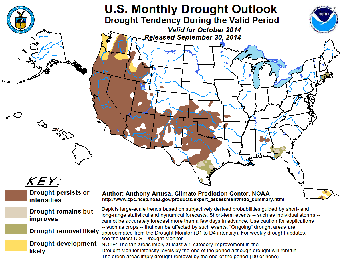
Significant changes in the weather pattern are predicted across the Southwest. With the climatological monsoon winding down, a
pronounced dry period is expected for most of the region in October. Farther north, across most of California, Nevada, Utah, and
the Pacific Northwest, a dry pattern is favored by recent climate model runs. Persistence and/or Intensification of drought, as
well as areas of possible Development is favored. In the central and southern Great Plains, climatology and the latest
extended-range predictions (days 6-14) tilt toward Persistence/Intensification of drought conditions for most of this region. In
southern Texas, however, Improvement and/or Removal is supported. In the East, the anticipated passage of several upper-air troughs
enhances the chances of Improvement and/or Removal of drought, both in New England and southern Georgia and adjacent parts of the
Florida Panhandle. In central Alabama however, October is typically the driest month of the year, and shorter-range rainfall
forecasts (days 1-14) depict sparse precipitation amounts. Therefore, Persistence/Intensification of drought is indicated. Dry
conditions are expected to continue over Hawaii and Puerto Rico in October, with a combination of Persistence, Intensification, or
drought Development favored.
|
|
Tools used in the U.S. Monthly Drought Outlook (MDO) included the official Climate Prediction Center (CPC)
updated temperature and precipitation outlooks for October 2014,
various short- and medium-range forecasts and models such as the 5-day and 7-day
precipitation totals from the Weather Prediction Center, the 6-10 day and 8-14 day CPC forecasts, the NAEFS precipitation
outlooks, the soil moisture tools based on the Constructed Analog on Soil (CAS) moisture, dynamical models (CFSv2, NMME, IMME, and IRI), the 384-hour total precipitation forecasts from several runs of the GFS, climatology, the latest official Drought Monitor analysis (made on September 23), observed precipitation during the last few weeks, and initial conditions.
Persistent periods of surface high pressure over the Northeast have resulted in a fairly dry pattern during the past two
weeks. Departure from Normal Precipitation (DNP) values for most locations range between 1-2 inches, with isolated 2-3 inch
deficits. The anticipated passage of several upper-air troughs during the ensuing two-week period is expected to result in
drought removal across New England. The October 2014 precipitation outlook calls for Equal Chances (EC) of below, near, and
above-median precipitation, due to weak and/or conflicting indications among the various models and tools.
Forecast confidence for the Northeast is moderate.
For much of the past two weeks, stationary fronts have stretched across the southern Atlantic and Gulf Coast states, attended
by moderate to heavy rainfall (generally 1-3 inches, though portions of the Florida peninsula and the Texas Gulf Coast region
reported anywhere from 5-10 inches). During the next two weeks, several upper-air troughs are predicted to progress across the
region, bringing opportunities for Improvement and Removal of drought across southern Georgia and the central Florida
Panhandle. However, Persistence is deemed the best bet in central Alabama, as October is typically the driest month of the
year for that area. The October 2014 precipitation outlook calls for Equal Chances (EC) of below, near, and above-median
precipitation, due to weak and/or conflicting indications among the various models and tools.
Forecast confidence for the Southeast is moderate.
During the last two weeks, precipitation deficits of 1-2 inches (isolated 2-3 inch amounts) have accumulated across most of
Oklahoma and north-northeast portions of Texas. For the majority of Texas however, precipitation has ranged from normal to
about 4-8 inches above-normal, due to a combination of influences, namely the monsoon and the presence of several stationary
fronts. In Kansas, the observed precipitation pattern has been mixed. For the extended-range period (days 6-14), the best
chances for precipitation are in southern Texas, which is most likely to have Improvement or Removal of drought. In contrast,
western and northern areas of the state are favored to have below-median rainfall. With the monsoon season winding down, and
climatological precipitation values dropping, Persistence is favored across much of northern and western Texas. The October
2014 precipitation outlook calls for Equal Chances (EC) of below, near, and above-median precipitation, due to weak and
conflicting indications.
Forecast confidence for the central and southern Great Plains is moderate.
Much of the Southwest has received beneficial precipitation this summer, thanks to a combination of factors such as a robust
Monsoon, a very active eastern Pacific hurricane season, backdoor cool fronts, and most recently a very amplified upper-air
trough. In the past two weeks, DNP values have ranged from near-median in many areas to as much as 4-5 inches above-median
(southern New Mexico, southern and western Arizona, western Utah, and adjacent parts of eastern Nevada). In central and
eastern Nevada and northwestern California, moderate precipitation (0.5-3.0 inches) was observed during the past two weeks.
During the upcoming two-week period, a dry pattern is anticipated across most of the region, coinciding with the climatological
winding down of the Southwest Monsoon. As a result, Persistence and/or Intensification of drought is predicted. One possible
exception could be far southeastern California and southwestern Arizona, where the opportunity remains for one or two Gulf
surges related to the active east Pacific hurricane season, and the warm ocean waters off Baja. The CFS climate model
supports enhanced odds of above-median rainfall in this region. However, it is doubtful whether there will be enough rainfall
to improve the drought by one-category. Odds for below-median precipitation are elevated in northern California, with EC
anticipated elsewhere.
Forecast confidence for the Southwest/California is moderate.
Across much of the central Inter-mountain region and the interior Pacific Northwest, light precipitation (less than 0.5-inch)
fell during the last 14-days. Moderate precipitation (0.5-2.0 inches, locally heavier) fell west of the Cascades and over
central and far eastern Nevada. The rainfall in Nevada was largely due to the recent passage of a very amplified 500-hPa
trough, unusually strong for this time of year. Though the precipitation over the Pacific Northwest coast signals the
climatological onset of the region's rainy season, it appears to be short-lived as a large, strengthening ridge is predicted
to move into the area during the extended-range period. Compared to the 0.5-month lead outlook for October, the updated
outlook calls for an expansion of warmer-than-normal temperatures across the Northwest, and somewhat higher probabilities.
Odds for below-median precipitation are enhanced throughout the extended and longer-range (monthly) forecast periods across
the Northwest and northern portions of the central Inter-mountain region.
Forecast confidence for the central Inter-mountain Region and Pacific Northwest is moderate to high.
No changes were made to the outlook for Hawaii or Puerto Rico, as dry conditions are expected to continue for both areas.
This is especially true for Puerto Rico, where there continues to be a pronounced lack of Atlantic and Caribbean tropical
systems this year.
Forecast confidence for Hawaii is moderate, and moderate to high for Puerto Rico.
|


