|
Latest Monthly Assessment -
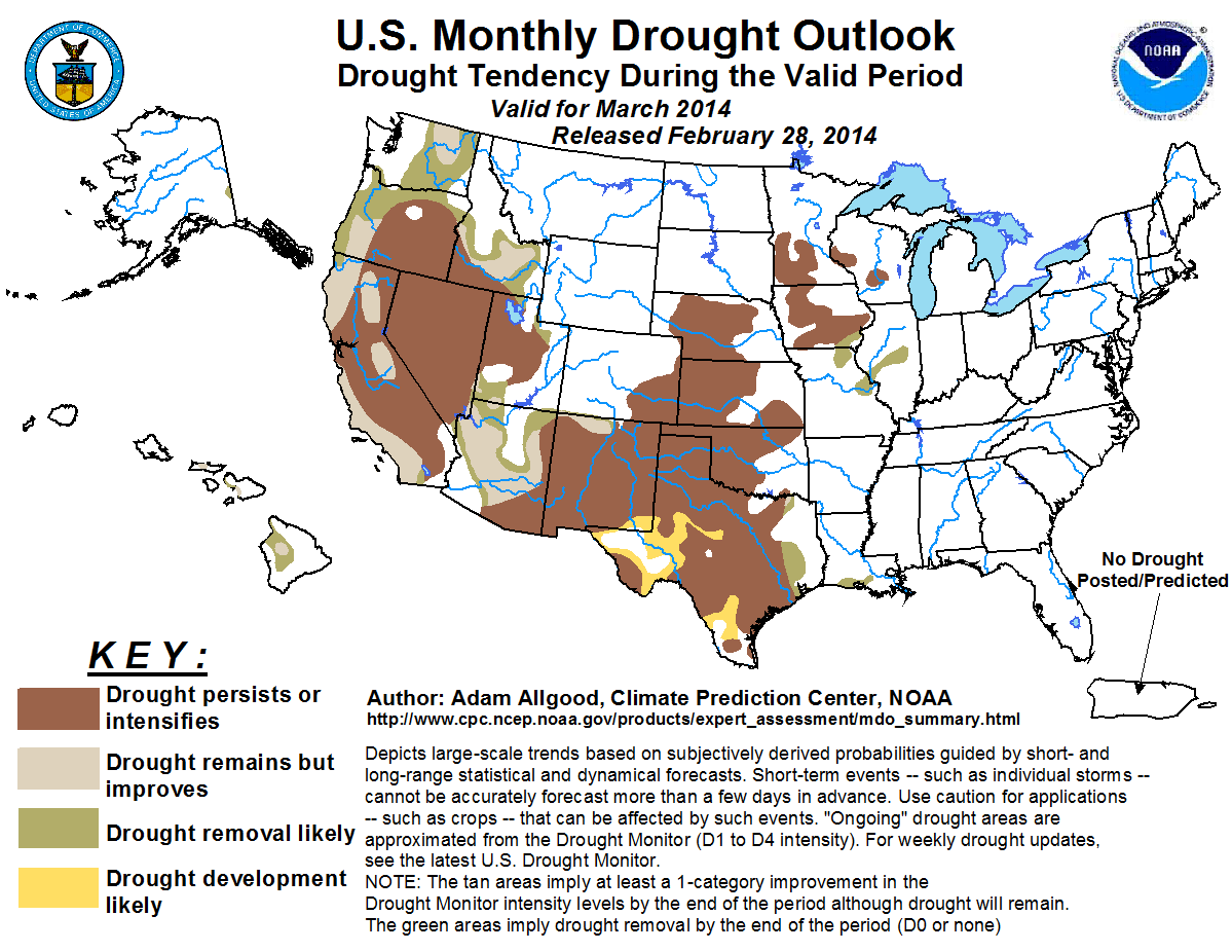
The March drought outlook is based on initial conditions, the Weather Prediction Center (WPC) 7-day precipitation forecast, the
Climate Prediction Center (CPC) 6-10/8-14 day precipitation outlooks, and the CPC monthly precipitation outlook. During the near
term, a powerful storm system over the northeastern Pacific is forecast to move ashore over California and weaken over the southern
Rockies, bringing widespread heavy precipitation to the coast, Sierra Nevadas, Cascades, and Rockies. The much needed precipitation
is anticipated to relieve ongoing drought conditions across parts of the West, especially across parts of coastal California and
Oregon, Washington, the northern Rockies, and parts of the Southwest. The efficacy of this storm system, though unusually intense,
to bring substantial drought relief to most of the Southwest is highly uncertain, due to short duration, extremely dry initial
conditions, and extended range and monthly forecasts tilting the odds towards above-median temperatures, which would promote rapid
snowmelt. Drought persistence is forecast over the Plains, with additional development possible across parts of western and
southern Texas, while widespread short term precipitation is anticipated to continue recent amelioration of drought across eastern
Texas, Louisiana, and the middle Mississippi Valley. Intrusions of bitterly cold and dry air masses over the upper Midwest favor
little change in soil conditions across the remainder of the Midwest, where ground and streams remain frozen. Periods of beneficial
rainfall favor continued drought improvement over Hawaii.
|
|
Tools used in the monthly U.S. Drought Outlook (MDO) included the official CPC temperature and precipitation outlook
for March 2014, various short- and medium-range forecasts and models such as the 6-10 day and 8-14 day forecasts, the
NAEFS and ESRL precipitation outlooks, the soil moisture tools based on the Constructed Analog on Soil (CAS)
moisture, dynamical models (CFSv2, NMME, and IMME), the 384-hour total precipitation forecasts from several runs of the
GFS, the 7-day quantitative precipitation forecast from the NCEP Weather Prediction Center (WPC), climatology, and
initial conditions.
An unusually deep mid-latitude storm system over the northeastern Pacific is forecast to move inland over California on
March 1 before weakening over the southern Rockies. Ample Pacific moisture streaming onshore is expected to generate
widespread heavy rainfall over coastal California, with heavy mountain snows across the Sierras. WPC 7-day outlooks
forecast localized accumulations of greater than 6 inches across coastal southern California, with 2 to 5 inches liquid
equivalent across the Sierras. Rainfall exceeding 7 inches is possible over extreme northwestern California. This
precipitation is much needed over California, where most of the state is currently experiencing severe (D3) to
exceptional (D4) drought conditions. The longer term efficacy of this early March storm to produce lasting drought
relief, however, is uncertain. It is more difficult to build snowpacks in March compared to mid-winter due to a higher
sun angle. Additionally, the CPC 6-10 day, 8-14 day, and monthly outlooks all tilt the odds towards above-median
temperatures for California, which would favor faster than usual melting of the new snow. Additionally, the coastal
precipitation is forecast to be heavy and of short duration, which would favor rapid runoff over extremely dry topsoils
rather than significant recharge. Following this storm system, drier conditions are anticipated to return to southern
California. Based on these considerations, drought improvement is limited to coastal areas where the highest
accumulations are forecast, and portions of the Sierras where the greatest snowfall is expected. Persistence is
maintained for much of the San Joaquin and Sacramento Valleys.
Forecast confidence for California is low to moderate, due to the uncertainty in the ultimate impacts of a single late
season storm.
Widespread heavy coastal rainfall and mountain snow are forecast during early March for the Northwest and northern
Rockies. Liquid equivalent accumulations over 9 inches are possible across the central Cascades straddling Washington
and Oregon, with 4 to 5 inch liquid equivalent accumulating over the northern Rockies. This precipitation is anticipated
to bring further drought relief to the Northwest, which recorded above-average precipitation during February after a very
dry start to the winter wet season. The CPC 6-10 day outlook tilts the odds towards above-median precipitation across
the Northwest, suggesting a continuation of the wet pattern into the second week of March. The CPC monthly outlook
maintains equal chances for below, near, or above-median precipitation. March is a climatologically wet time of year for
the Northwest, with a decreasing climatology towards the end of the month. Based on the wet signal during the first half
of March, widespread drought reduction is anticipated for Washington, western Oregon, and much of Idaho. Drought
persistence is maintained across central Oregon and far southwestern Idaho, where initial SWE values are low.
Forecast confidence for the Northwest is moderate to high.
Streaming Pacific moisture from a weakening storm system over the Four Corners region is forecast to generate significant
rain or snow across the higher terrain of Arizona, parts of Utah, and extreme northern New Mexico. Liquid equivalent
accumulations topping 3 inches are possible over central Arizona during the first days of March, which is greater than
the total monthly average precipitation. Based on the very wet short term forecast, drought improvement is anticipated
across northern and central Arizona. Improvement is also possible across the Rockies of far northern New Mexico, though
extremely dry initial conditions across the remainder of the state make substantial improvements less likely.
Improvement or removal is forecast for northeastern and far southwestern Utah, consistent with the expected areas of
heaviest precipitation totals.
Forecast confidence for the Four Corners states is moderate.
March is a climatologically dry time of year for the northern, central, and high Plains, although climatological
precipitation increases during the month over the southeastern Plains as Gulf moisture begins penetrating further north
and west. A developing winter storm is forecast to bring precipitation to eastern Kansas, Oklahoma, and Texas in the
near term, with the highest accumulations forecast to fall east of the Plains. The CPC 6-10 and 8-14 day outlooks tilt
the odds towards below-median precipitation across the central and southern Plains, while the March outlook indicates
enhanced chances of below-median precipitation across the eastern Dakotas. Intrusions of arctic air are possible during
the first half of March, which would promote dry conditions and reduced snow melt. Based on climatology and these
outlooks, drought persistence is forecast for the Plains. A continuation of dryness across western and southern Texas
may promote additional drought development in areas experiencing abnormal dryness during the winter. A smaller than
average snowpack over parts of the Dakotas may provide insufficient early spring moisture, but impacts would be felt
largely after this forecast period.
Forecast confidence for the Plains is moderate to high.
Drought improvement was indicated during the last two weeks of February across the Midwest due to plentiful snowpack
conditions and saturated topsoils, albeit frozen. March is a climatologically dry time of year for the Midwest. During
early March, a storm system is anticipated to bring widespread precipitation to the Ohio Valley. The additional snow may
promote additional drought improvement across northern Missouri, extreme southeastern Iowa, and Illinois. Outbreaks of
dry and bitterly cold arctic air are likely during the first half of March, however, with the CPC monthly outlook tilting
the odds towards below-median temperatures and below-median precipitation. Little melting of ground moisture and streams
is anticipated based on this cold outlook, which would limit any absorption of the extant snowpack into the ground.
Based on the deeply frozen ground conditions, climatology, and the anticipated continuation of cold conditions during
March, drought persistence is forecast for the remainder of Iowa, Minnesota, and Wisconsin.
Forecast confidence for the Midwest is moderate to high.
Frontal systems across the Gulf Coast brought widespread heavy rainfall during the past week to far eastern Texas and
southern Louisiana, where weekly percent of normal rainfall values were greater than 200 percent. The recent rainfall
has resulted in drought reduction across Louisiana and eastern Texas, following a dry start to the winter. Additional
widespread rainfall is forecast during early March, which is anticipated to promote additional drought reduction across
Louisiana and eastern Texas.
Forecast confidence for eastern Texas and southern Louisiana is high.
Recent much needed above-average rainfall across Hawaii brought additional drought relief, with small areas of moderate
to severe drought remaining over the Big Island, and moderate drought over Kahoolawe and extreme eastern Maui. CFS and
GFS forecasts indicate above-average precipitation over the eastern Hawaii during the upcoming two weeks, which would
likely promote additional drought reductions during March.
Forecast confidence for Hawaii is moderate to high.
A small area of moderate drought remains over eastern Alaska near the Canadian border. Snow cover in this region is
deeper than normal, which favors drought removal, especially once spring melting commences.
Forecast confidence for Alaska is high.
|


