|
| |
 |
| |
|
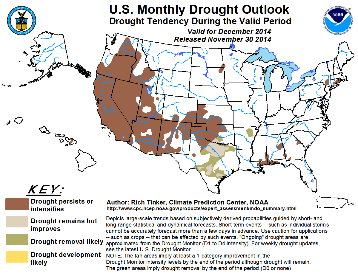
December 2014
|
| |
|
Outlook Graphic: PNG PDF 
|
| |
|
Latest Monthly Assessment -
In the last 2 weeks, since the release of the last Seasonal Drought Outlook, many areas across the southern Plains and the
south Atlantic coastal states saw at least limited improvement. Drought persisted or deteriorated in areas along the central
Gulf Coast, and was generally unchanged from the High Plains westward, including Hawaii.
During December, the pattern of slow, patchy improvement in the southern Plains is expected to continue, but other areas of
drought should persist or possibly deteriorate during the month. In the region of improvement, odds favor above-normal
December precipitation, with an episode of heavy rain possible by mid-month. In addition, an increase in modeled soil moisture
content is not uncommon in this region during December, which is not the case farther west and north in the central and
southwestern Plains. Notable drought improvement is not anticipated in this region because it is climatologically drier in
winter, making improvement unlikely even with above-normal precipitation.
Odds do not favor a wet December in the drought areas in the northern Plains, the Southeast, and the Northeast. In fact, some
indicators point toward sub-normal precipitation for the first half of the month, making improvement by the end of December
unlikely.
Drought is expected to persist where it exists across the Intermountain West and Far West, including California. Odds favor
above-normal December precipitation throughout these areas, except in the central and northern Intermountain West, and
December is one of the wetter months climatologically in the West, especially California. However, the end of December is
still early in the wet season, and considering the entrenched multi-year nature of the drought in California, conditions are
not expected to improve substantially by the end of the month (although the Seasonal Drought Outlook indicates that
improvement is likely by the end of winter). The Weather Prediction Center forecasts 3 to locally 7 inches of precipitation
for the first week of December in northern and central sections of both the mountains and the western coastline. However,
precipitation amounts are over a foot below normal here for the past year, and 2-year shortfalls are almost twice as large in
some sections. In addition, December normals are large, so it will take more than one or even a few such episodes to bring the
1- to 3-year accumulated deficits down substantially.
The odds favor drier than normal weather in Hawaii during December, and indeed for the winter as a whole. Drought should
persist where it exists, but December should not be dry enough to bring expansive drought development by the end of the year.
|
| |
|
Discussion for the Monthly Drought Outlook
|
| |
|
Tools used in the U.S. Monthly Drought Outlook (MDO) included the official Climate Prediction Center (CPC)
updated temperature and precipitation outlooks for December 2014, various short- and medium-range forecasts and models such
as the 5-day and 7-day precipitation totals from the Weather Prediction Center, the 6-10 day and 8-14 day CPC forecasts, the
NAEFS precipitation outlooks, the soil moisture tools based on the Constructed Analog on Soil (CAS) moisture, dynamical models
(CFSv2, NMME, IMME, and IRI), the 384-hour total precipitation forecasts from several runs of the GFS, climatology, the latest
official Drought Monitor analysis (made on November 25), observed precipitation during the last few weeks, and initial
conditions.
The patches of drought scattered across the Southeast, the Northeast, and the northern Plains are expected to persist through the end of 2014. Odds favor neither above- nor below-normal precipitation for the month as a whole, and short-term indicators show near- to below-normal precipitation in these areas over the next two weeks. As a result, significant drought improvement is unlikely.
Confidence in the forecast across the Northeast, the Southeast, and the northern Plains is moderate to high.
Patchy improvement has been observed across the south-central Plains during the past several weeks, and this general trend is expected to continue through the end of December. After a fairly dry week, heavy precipitation may overspread the region during the second week of the month, and odds favor a wet December as a whole. Still, it was tricky determining how far west to bring improvement. In the central and southwestern Plains, December is one of the drier months of the year, and increased modeled soil moisture totals are observed only 10% to 40% of the time climatologically. Persistence seemed the better forecast here. On the other hand, December soil moisture content increases more frequently from the south-central Plains eastward, and December is not a particularly dry time of the year here. All of this argues for a better chance for improvement in south-central and southeastern sections of the Plains in constrast to areas farther north and west. Improvement or removal is forecast where the expected axis of heavy precipitation and the higher relative frequency of December improvement best coincide.
Confidence for the forecast in the central and southern Plains is high, though less so near the boundary between the improvement/removal and persistence forecasts.
Drought conditions in the southern Rockies, the Great Basin, the Southwest, and the West Coast should persist through the end of December. There are several potential arguments for a forecast of improvement or removal in much of the region, including California: Wetness in the short term across the higher elevations and northwestern section of California and adjacent Oregon; odds favoring above-normal precipitation for December as a whole; the start of the wettest time of year from the western Rockies westward, particularly across central and northern California, where December has brought 20% to 25% of the annual precipitation total on average during the last 15 years. However, persistence is forecast because of (a) the entrenched, multi-year nature of the drought in California, and (b) the fact that the end of December is early in the wet season, and even abundant December precipitation does not guarantee above- nor even near-normal precipitation for the winter as a whole. This is especially true of mountain snowpack.
Confidence in the forecast across the West is high
The odds favor a dry winter across Hawaii, which could spread drought throughout the state by early spring. December 2014 is likewise expected to be drier than normal, but not enough to induce large-scale drought development until after the end of the year. The small areas of drought that exist should persist.
Confidence in the forecast for Hawaii is high.
|
|


