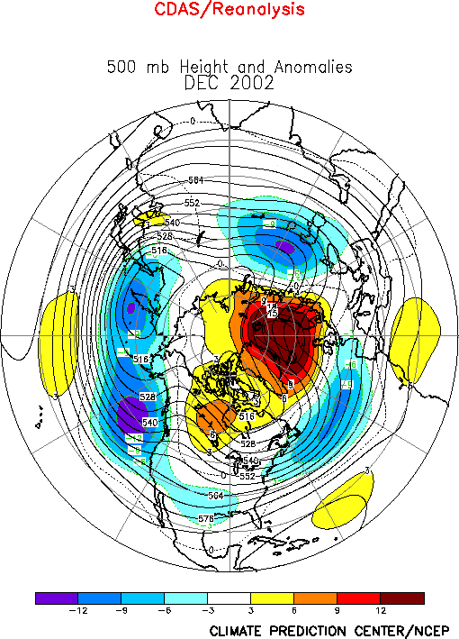
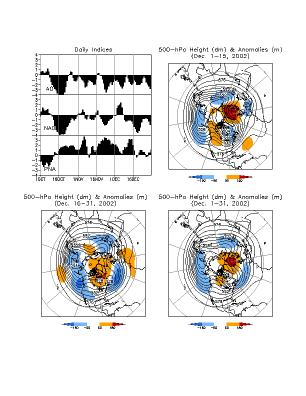
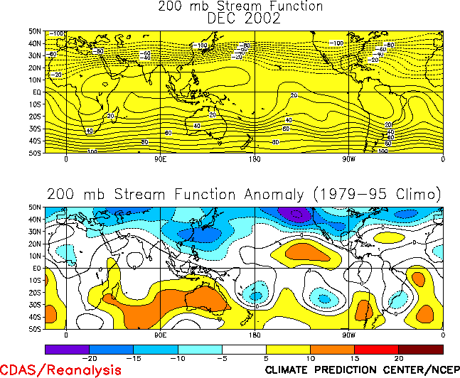
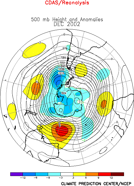
The 500-hPa
circulation during December featured positive height anomalies over
the polar region and in the subtropics, and negative height anomalies
in the middle latitudes (Fig. E10).
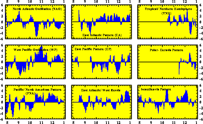
These anomalies project onto several major teleconnection patterns,
each of which has persisted since October (Table
E1, Figs. E7, E8).
Over the Pacific Ocean they reflect the positive phases of the
Pacific/ North American (PNA) and West Pacific (WP) patterns. Over the
Atlantic Ocean they reflect the negative phase of the North Atlantic
Oscillation (NAO) and positive phase of the East Atlantic (EA)
pattern. The persistence of these patterns in both ocean basins is
consistent with the ongoing El Niño
and negative phase of the Arctic Oscillation (Fig.
A2.1)
.
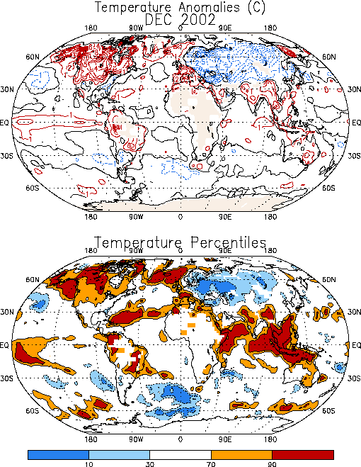
The prominent temperature anomalies during December included much
warmer than normal conditions across the northern half of North
America and southern Europe, and cooler than normal conditions across
northern Europe, Scandinavia, and western/ central Russia (Fig. E1).
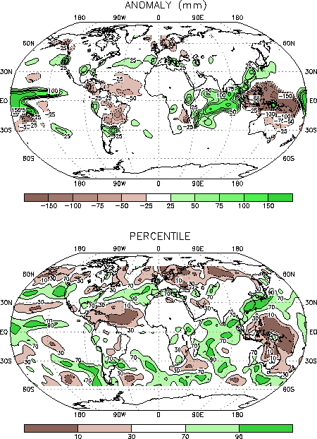
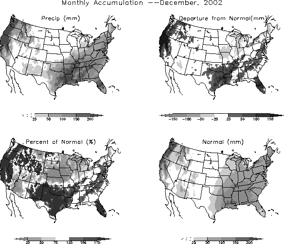
Prominent precipitation departures during the month included
above-average precipitation across the southern and eastern portions
of the United States (Figs. E3, E5,
E6) and across southern
Europe (Figs. E3, E4), and below-average precipitation over
western Canada and northern Europe/ Scandinavia
a. Pacific/North America
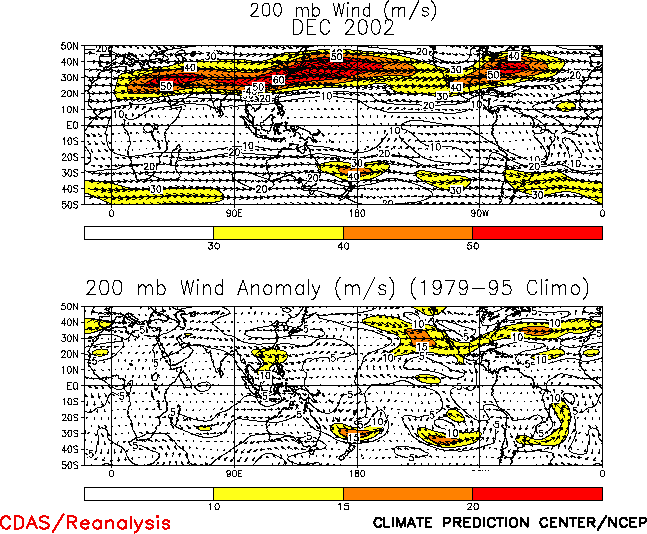
The strong positive PNA (+1.1) and West Pacific (+1.4) patterns
during December (Table E1) reflected an amplified upper-level
trough across the central and high latitudes of the North Pacific, an
amplified ridge over western Canada, and a reduced strength of the
trough over the subtropical eastern North Pacific (Figs. E10,
T22).
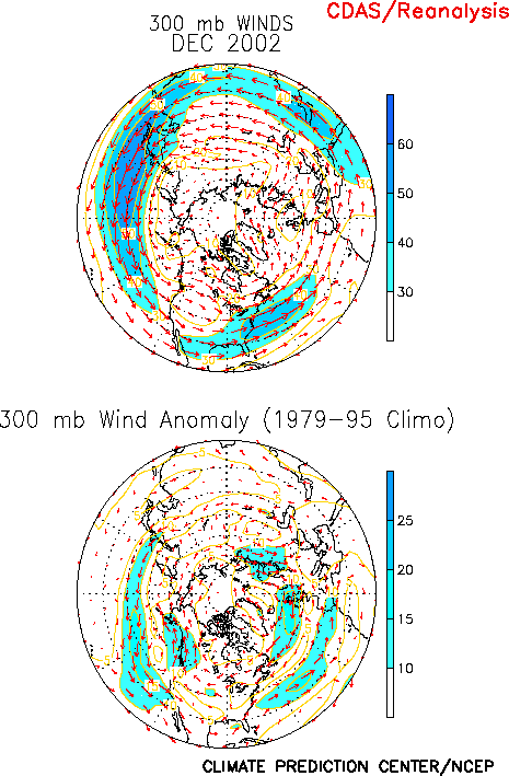
These anomalies were associated with an extension of the East Asian
jet stream across the eastern North Pacific, and with an eastward
shift of the mean jet exit region and accompanying split-flow
configuration to the western U.S. (Fig. E11). The axis of the
East Asian jet stream was also shifted to the extreme southwestern
United States, which is well south of its climatological mean position
in the Pacific Northwest. This jet stream configuration is consistent
with the atmospheric response to mature El Niño
conditions.
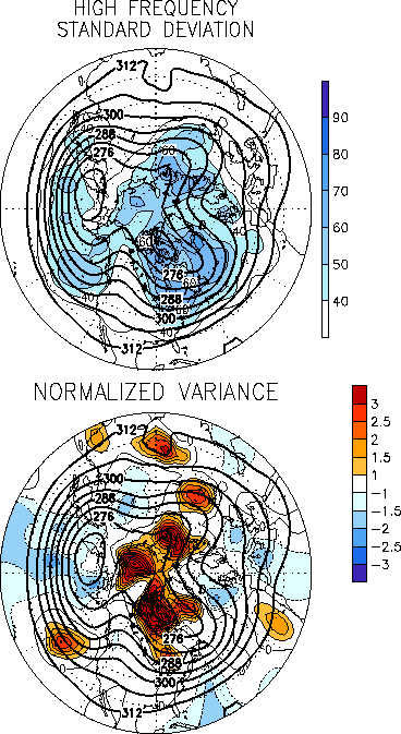
This circulation was associated with increased storminess in the
anomalous jet exit region (Fig. E14). Several of these storms
moved into California, strengthened while passing across the southern
half of the U.S., and developed into major east-coast cyclones. This
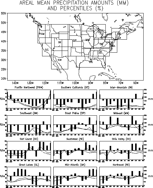
anomalous low-latitude storm track resulted in above-average
precipitation across California, the Gulf Coast, the Southeast, the
mid-Atlantic, and the Northeast (Figs. E3, E5). Each of these
regions has recorded above-average precipitation during the last three
months (Fig. E5). This combination of above-average
precipitation and increased storminess across the south is also
consistent with the atmospheric response to El Niño.
A strong flow of marine air into western North America during
December contributed to above-average surface temperatures over the
northern half of the continent. In Alaska and Canada temperatures
ranged from 4-8°C above average while over
the northern U.S. they ranged from 2-4°C
above average (Fig. E1). This anomalous warmth is also
consistent with the ongoing El Niño.
b. North Atlantic and Europe
The circulation over the North Atlantic and Europe featured
above-average heights at high latitudes and below-average heights in
the middle latitudes (Fig. E10). This circulation was
associated with high-latitude blocking and a pronounced split-flow
configuration over the eastern North Atlantic and Scandinavia, and
with a southward shift of the mean wintertime jet axis to southern
Europe (Figs. E11, T21). This overall anomaly pattern has
persisted since October, and reflects the ongoing negative phase of
the NAO and positive phase of the East Atlantic teleconnection pattern
(Table E1, Figs. E7,
E8).
During December these conditions were associated with a
continuation of warmer and wetter than normal conditions across
southern Europe, and cooler and drier than normal conditions in
Scandinavia (Figs. E1, E3). The combination of high-latitude
blocking over Scandinavia and a very strong upper-level trough over
central Russia also contributed to significantly below-averaged
surface temperatures across western and central Russia (Fig. E1),
with temperatures over western Russia ranging from 4-7°C
below average and falling within the lowest 10th percentile
of occurrences.
2. Southern Hemisphere
The upper-level circulation during December featured above-average
heights in the middle latitudes and across the subtropical eastern
South Pacific, and below-average heights in the polar region (Fig.
E16). Over the eastern South Pacific this circulation was
associated with enhanced jet stream winds along the poleward flank of
the subtropical anticyclonic circulation anomalies, consistent with
the ongoing El Niño (Figs. E17, T21).
In South America prominent precipitation anomalies during December
reflected the continuation of below-average precipitation in
northeastern and northern sections and enhanced precipitation in
southern Brazil and northern Argentina (Figs. E3,
E4, T25).
Below-average precipitation was also observed across northern and
northeastern Australia, with monthly totals again below the 10th
percentile. These rainfall patterns are consistent with the ongoing El
Niño. Much of eastern
Brazil and eastern Australia were again considerably warmer than
normal during the month, with temperatures exceeding the 70th
percentile in both areas (Fig. E1).
In South Africa the rainy season typically lasts from October to
April. The first three months of the 2002-2003 rainy season have
featured below-average rainfall (Fig. E4). During December this
dryness was associated with a persistent upper-level ridge/ trough
system, with eastern South Africa situated downstream of the mean
ridge axis in an area of anomalous sinking motion (Fig. T22).


