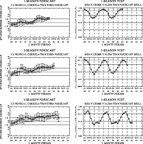
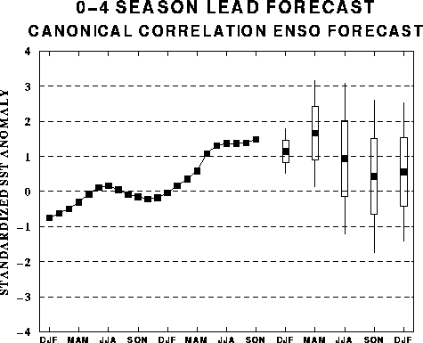
The canonical correlation analysis
(CCA) forecast of SST in the central Pacific (Barnett et al. 1988, Science, 241,
192-196; Barnston and Ropelewski 1992, J. Climate, 5, 1316-1345), is shown
in Figs. F1 and F2. This forecast
is produced routinely by the Prediction Branch of the Climate Prediction Center. The
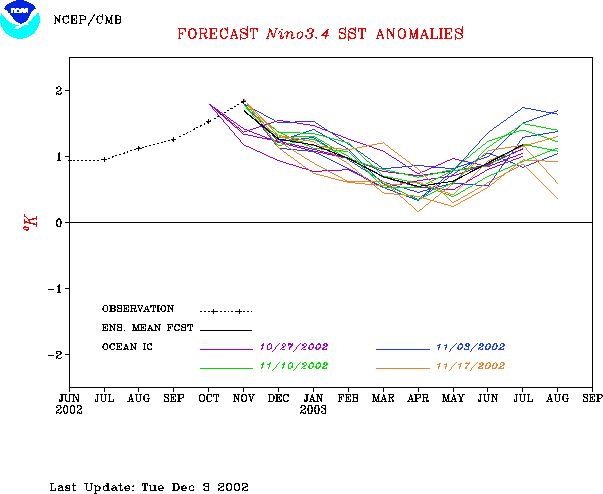
predictions from the National Centers for Environmental Prediction (NCEP) coupled
ocean/atmosphere model (Ji et al. 1998, Mon. Wea. Rev, 126, 1022-1034) are
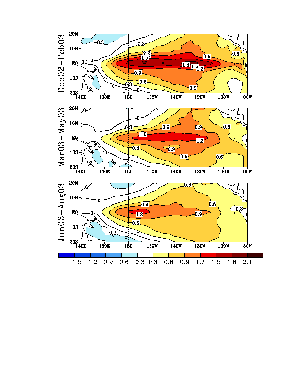
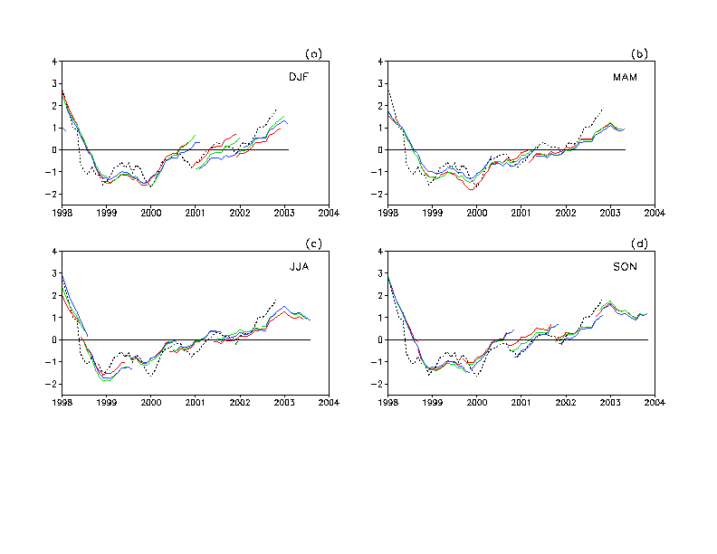
presented in Figs. F3 and F4a, F4b. Predictions from the Markov model (Xue, Y., A. Leetmaa,
and M. Ji, 2000: ENSO prediction with Markov model: The impact of sea level. J. Climate,
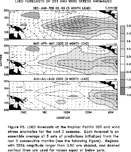
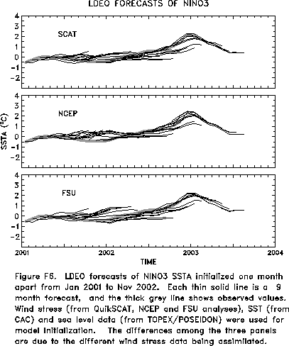
13, 849-871) are shown in Figs. F5 and F6.
Predictions from the latest version of the LDEO model (Chen, D., M. A. Cane, S.
E. Zebiak, Rafael Canizares and A. Kaplan, 2000, Geophys. Res. Let., 27,
2585-2587) are shown in Figs. F7 and F8.
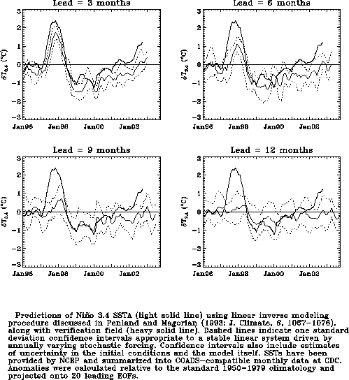
Predictions using linear inverse modeling (Penland and Magorian 1993, J. Climate, 6,
1067-1076) are shown in Figs. F9 and F10.
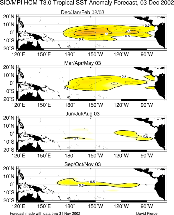
Predictions from the Scripps / Max Planck Institute (MPI) hybrid coupled model (Barnett et
al. 1993, J. Climate, 6, 1545-1566) are shown in Fig. F11. Predictions from the ENSO-CLIPER statistical model
(Knaff, J. A. and C. W. Landsea 1997, Wea. Forecasting, 12, 633-652) are
shown in Fig. F12.
The CPC and the contributors to the Forecast Forum caution potential users of
this predictive information that they can expect only modest skill.
Outlook
Based on the observed oceanic and atmospheric conditions and the
SST predictions, warm episode (El Niño)
conditions are expected to continue through the spring of 2003.
Discussion
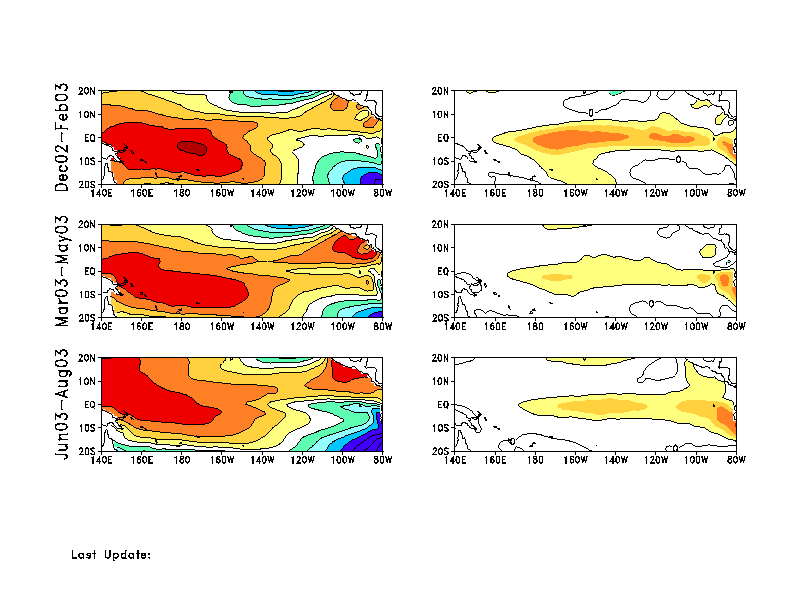
Further evolution of warm episode (El Niño)
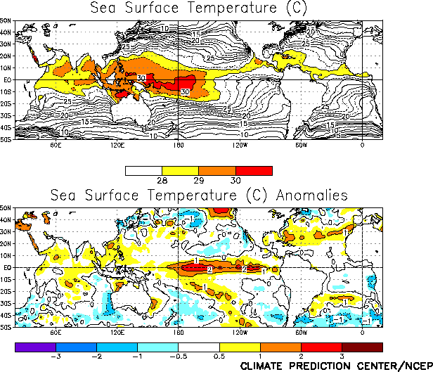
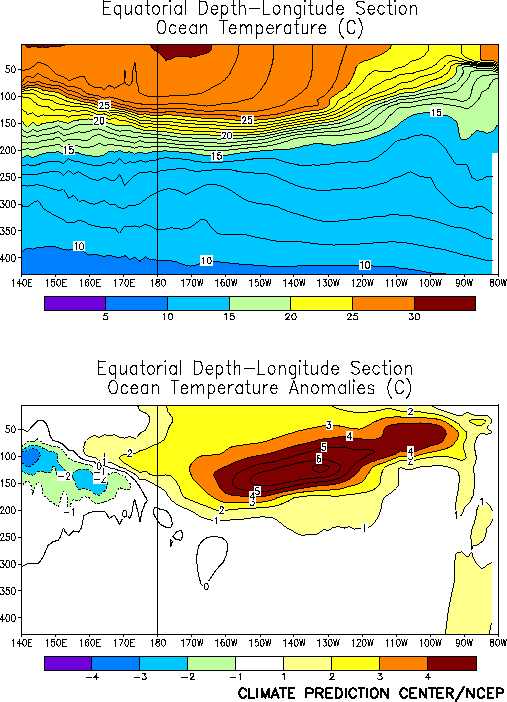
conditions occurred in the tropical Pacific during November 2002. SST
anomalies (departures from average) were greater than +1°C
throughout the equatorial Pacific between 170°E
and the South American coast during the month (Fig. T18).
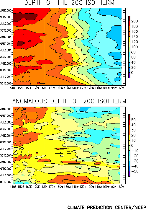
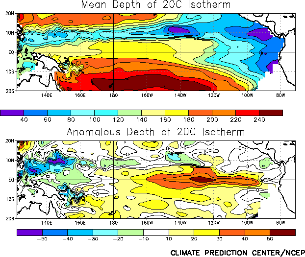
Positive subsurface temperature departures (Fig. T17) and a
deeper-than-average oceanic thermocline (Figs. T15 and
T16) prevailed throughout the equatorial Pacific east of 170°E. Negative subsurface temperature departures and a
shallower-than-average oceanic thermocline were observed west of 170°E, consistent with El Niño
conditions.
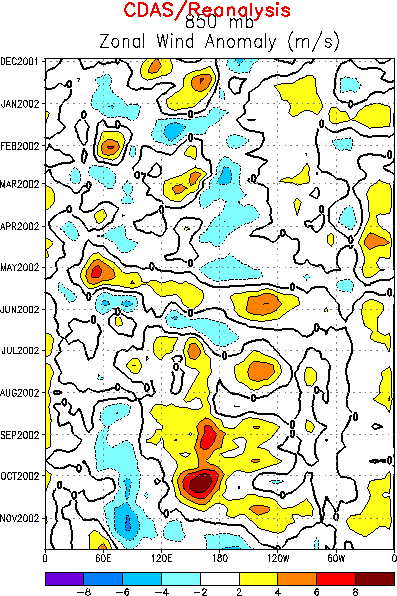
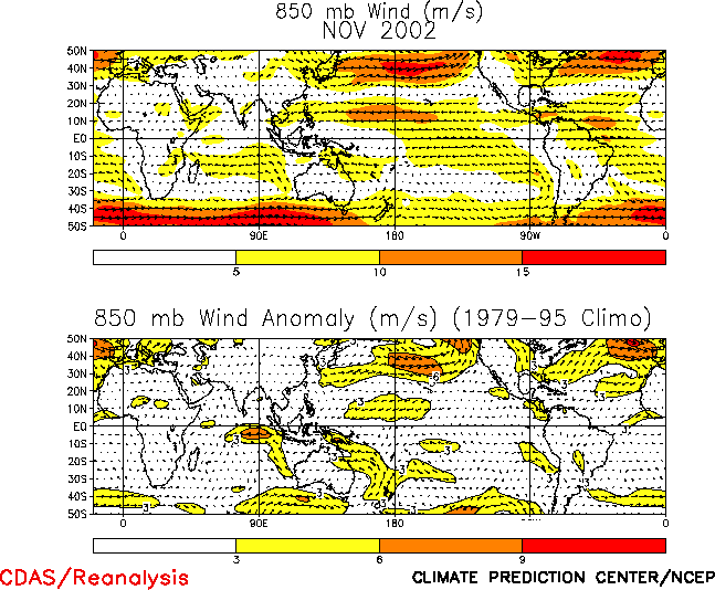
Most atmospheric indicators remained consistent with the ongoing
warm episode during November (Table T1). The low-level
equatorial easterly winds over the Pacific basin exhibited
considerable week-to-week variability during the month in response to
Tropical intraseasonal (Madden Julian Oscillation) activity (Table
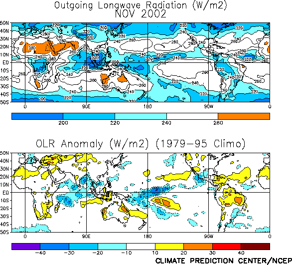
T1; Fig. T13; Fig. T20). Wetter-than-average conditions were
observed over the tropical Pacific, especially in the vicinity of the
date line (180°W) and over southeastern South America, while drier-than-average conditions
prevailed over portions of Indonesia, eastern Australia and southern
Africa (Fig. T25; Fig. E3). These oceanic and atmospheric
conditions indicate the presence of El Niño.
Most coupled model and statistical model forecasts indicate that El
Niño conditions will continue through the Northern Hemisphere spring
of 2003 (Figs. F1, F2,
F3, F4, F5,
F6, F7, F8,
F9, F10, F11,
F12). Thereafter the forecasts are more
uncertain, though most models indicate a continuation of El Niño
conditions through the summer. This uncertainty arises during a time
of the year when all of the techniques have difficulty in making
skillful forecasts. It is also worth noting that most of the forecasts
have underestimated the observed positive SST anomalies in recent
months. Based on the recent evolution of conditions in the tropical
Pacific, we expect SST anomalies to increase further in the eastern
equatorial Pacific (Niño 3 and Niño 1+2 regions) during the next few
months.
Expected global impacts include: 1) drier-than-average over
Indonesia and eastern Australia continuing during the next several
months, 2) drier-than-average over southeastern Africa during December
2002-February 2003, 3) drier-than-average over Northeast Brazil and
northern South America during December 2002-April 2003, and 4)
wetter-than-average conditions over coastal sections of Ecuador and
northern Peru during December 2002-April 2003. Over the United States
and Canada we expect: 1) drier-than-average conditions in the Ohio
Valley states and northern Rockies during winter 2002-2003, 2)
wetter-than-average conditions along much of the southern tier of the
U.S. during winter 2002-2003, and 3) warmer-than-average conditions in
the northern tier states, southern and southeastern Alaska, and
western and central Canada during late fall 2002 and winter 2002-2003.
Weekly updates of SST, 850-hPa wind, OLR, and the equatorial subsurface temperature
structure are available on the Climate Prediction Center homepage at:
http://www.cpc.ncep.noaa.gov (Weekly Update).


