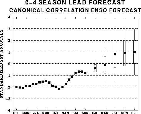
The canonical correlation analysis (CCA) forecast
of SST in the central Pacific (Barnett et al. 1988, Science, 241, 192-196;
Barnston and Ropelewski 1992, J. Climate, 5, 1316-1345), is shown in Figs.
F1 and F2. This forecast is produced
routinely by the Prediction Branch of the Climate Prediction Center. The predictions from
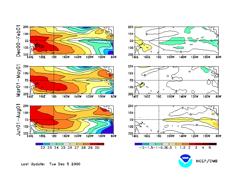
the National Centers for Environmental Prediction (NCEP) coupled ocean/atmosphere model
(Ji et al. 1998, Mon. Wea. Rev, 126, 1022-1034) are presented in Figs. F3 and F4. Predictions from the latest
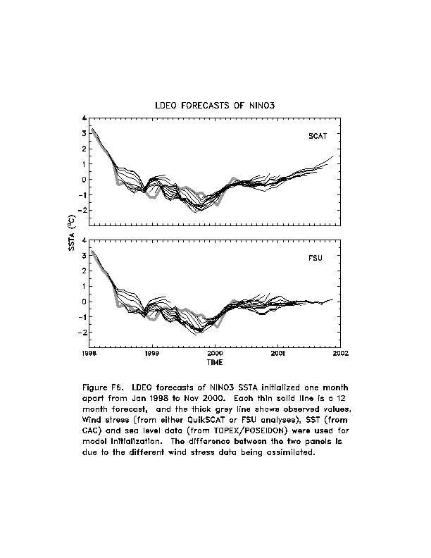
version of the LDEO model (Chen, D., M. A. Cane, S. E. Zebiak, Rafael Canizares and A.
Kaplan, 2000, Geophys. Res. Let., accepted) are shown in Figs. F5 and F6. Predictions using linear
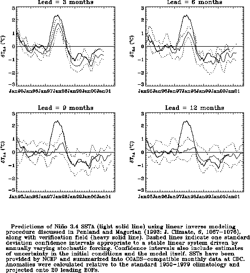
inverse modeling (Penland and Magorian 1993, J. Climate, 6, 1067-1076) are
shown in Figs. F7 and F8.
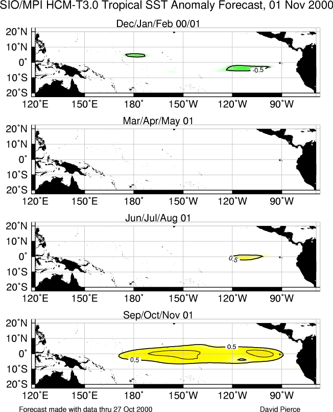
Predictions from the Scripps / Max Planck Institute (MPI) hybrid coupled model (Barnett et
al. 1993, J. Climate, 6, 1545-1566) are shown in Fig. F9.
The CPC and the contributors to the Forecast Forum caution potential users of
this predictive information that they can expect only modest skill.
Outlook
A gradual weakening of cold episode (La Nińa) conditions in the tropical Pacific is
expected during the NH winter followed by near-normal conditions through the spring of
2001.
Discussion
The large-scale oceanic and atmospheric circulation patterns during November
were consistent with weak cold episode conditions in the tropical Pacific. Cold
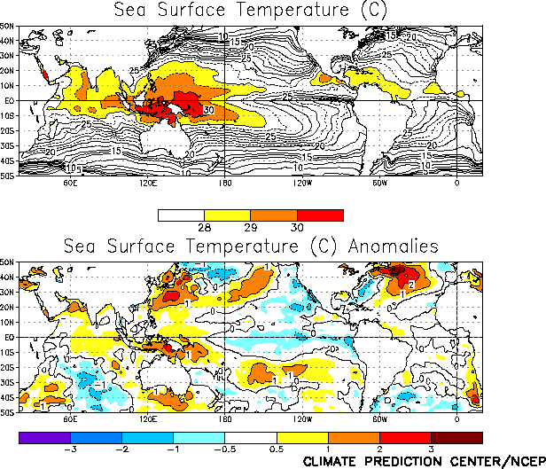
episode-related oceanic features included below normal SSTs (negative anomalies up to
-1°C) in the central and eastern equatorial Pacific (Fig. T18),
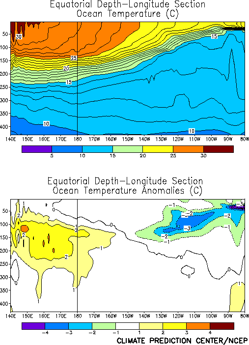
and above- (below-) normal subsurface temperatures in the western (eastern) equatorial
Pacific (Fig. T17). Related atmospheric features included
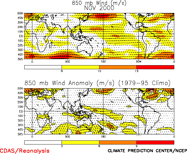
stronger-than-normal low-level easterly winds over the central and west-central tropical
Pacific (Fig. T20), above-normal precipitation over the
Phillippines, Indonesia and northern Australia (Fig. T25),
and suppressed rainfall over the west-central and central equatorial Pacific (Fig. T25). During November the pattern of tropical convection
was strongly influenced by tropical intraseasonal (Madden-Julian Oscillation) activity,
especially over the eastern Indian Ocean, Indonesia and the western Pacific (Fig. T11).
A notable feature of the current oceanic conditions is the lack of evolution of the
subsurface thermal structure in the tropical Pacific from a pattern that is typical of the
mature phase of cold episodes towards a pre-warm episode state. Thus, it is likely that
weak cold episode conditions will be present for the next several months. This assessment
is supported by the most recent NCEP statistical and coupled model forecasts (Figs.
F1, F2, F3, F4), as well as by other available coupled model and
statistical model predictions (Figs. F5, F6,
F7, F8, F9)
that indicate a gradual weakening of cold episode conditions in the tropical Pacific
through the NH winter, followed by near-normal SSTs during the spring of 2001.
Based on current conditions in the tropical Pacific, on the NCEP SST predictions, and
on results from historical studies on the effects of cold episodes, we expect
wetter-than-normal average conditions to prevail over Indonesia, northern Australia, and
southern Africa during the NH winter. Due to enhanced MJO activity, we also expect
increased rainfall variability in the tropics and subtropics (30°S-30°N) through the
period. Over the United States warmer-than-normal average conditions are expected along
the southern tier of states from southern California eastward to Florida.
Cooler-than-normal average conditions are likely over western and central Canada and in
the upper Midwest and Great Lakes.
Weekly updates of SST, 850-hPa wind and OLR are available on the Climate Prediction
Center homepage at: http://www.cpc.ncep.noaa.gov (Weekly
Update).
