Tropical Highlights - October 2002
The evolution toward mature Pacific warm episode (El Niño)
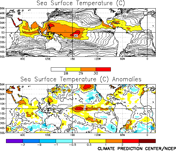
conditions continued during October 2002 as sea surface temperature (SST) anomalies continued to increase across the equatorial Pacific
east of the date line (Table T2). Positive SST anomalies
exceeded +1°C between the date line and 100°W and +2°C between 175°W and 140°W
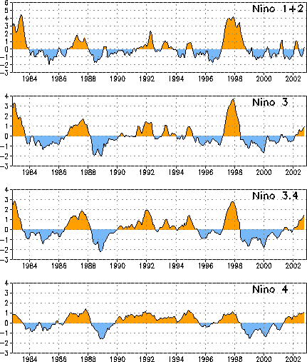
(Fig. T18). Consistent with this warmth the Niño
3.4 SST index increased to 1.5, its largest value since March 1998 near the end of the 1997-98 El Niño
episode (Fig. T5, Table T2).
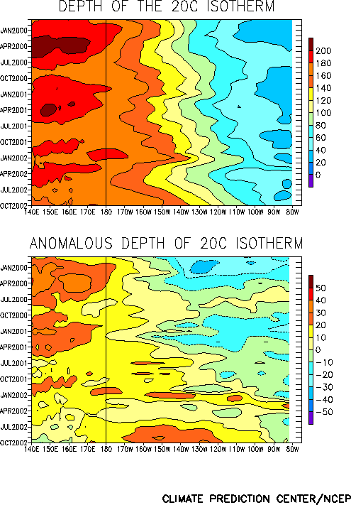
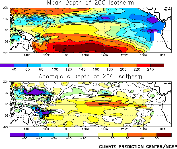
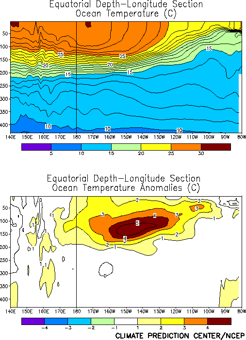
Consistent with the ongoing Pacific warm episode, the oceanic
thermocline remained deeper than normal across the central and eastern
equatorial Pacific (Figs. T15, T16). Sub-surface ocean
temperatures in the equatorial central and east-central Pacific also remained 4-5°C above normal
at thermocline depth between 160°W and 125°W (Fig. T17),
indicating a deep layer of oceanic warmth to support a likely continuation of El Niño conditions into the March-May 2003 season.
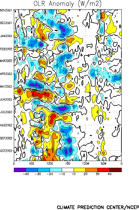
Convection remained enhanced across the central equatorial Pacific during October, and suppressed over Indonesia and the western Pacific
(Fig. T25). This pattern has persisted since August (Fig.
T11) and is consistent with ongoing warm episode conditions. The central Pacific OLR index has averaged near -1.5 since August, its
lowest value since late 1997 (Fig T1).
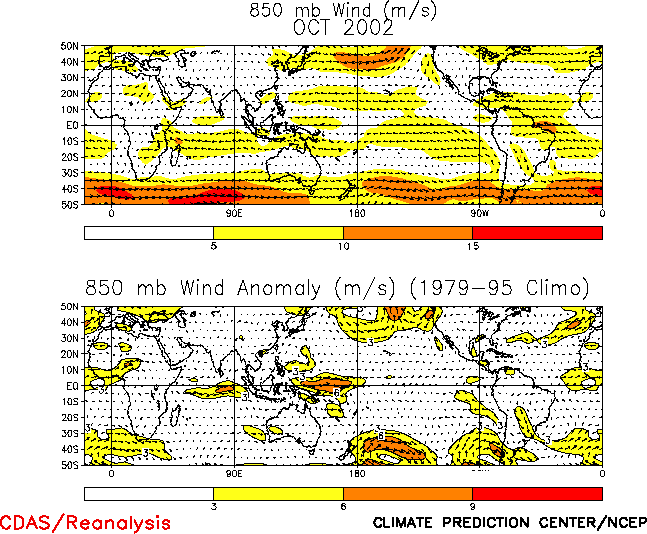
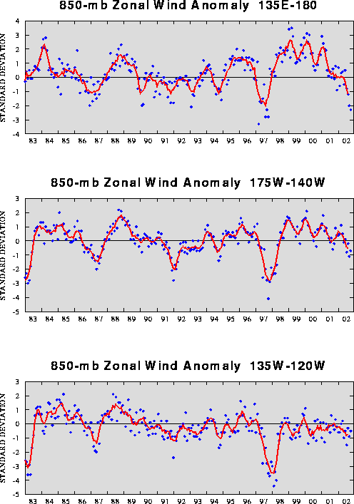
The low-level (850-hPa) equatorial easterly winds remained weaker
than normal across the central and eastern Pacific during October 2002 (Figs. T7, T13, T20), while the formation of equatorial
westerly winds in the west resulted in the largest negative 850-hPa zonal wind index for that region since October 1997 (Table
T1, Fig. T4, top). These conditions are consistent with the El Niño-
related anomalous tropical convection (Table T1, Figs. T4, T7).
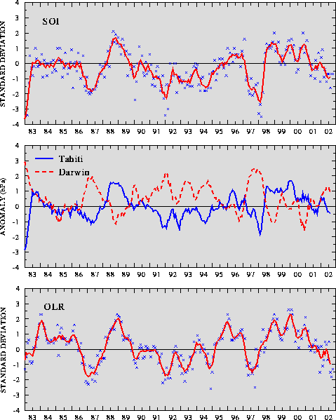
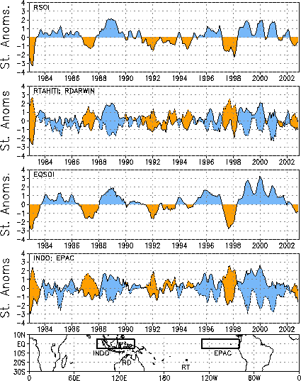
The tropical sea-level pressure (SLP) pattern reflected an anomalous wave-1 pattern during October, with much below-average
pressure over most of the tropical Pacific and near-average pressure elsewhere (Fig. T19). This pattern resulted in negative values
of both the Tahiti-Darwin Southern Oscillation Index (SOI) (-0.7) and the equatorial SOI (-0.9) (Figs. T1, T2, respectively). The SOI
has fluctuated between -0.5 and -1.5 since March 2002 (Table T1), with the five-month running mean approaching -1.0.
Editor’s Note: A change to the global precipitation analyses (Figs. E3, E4,
E5) was implemented this month. Until now, the global precipitation analysis used monthly rain gauge observations
from the GTS (Global Telecommunications System) over the entire globe. Beginning with October 2002 data, the CPC daily rain gauge analyses
were used over the U.S., Mexico and South America, which are made from considerably denser networks than are available from the GTS. To
ensure consistency when computing anomalies, the global precipitation analyses for January 1979 through September 2002 were re-run to
incorporate these data over the U.S. and Mexico, but not over South America because data from that region were not available for the
entire record. The gamma distribution parameters were then recomputed. This change results in differences in the time series of precipitation
percentiles over the U.S. (Fig. E5 this issue) compared to those found
in previous issues of the Climate Diagnostics Bulletin.


