|
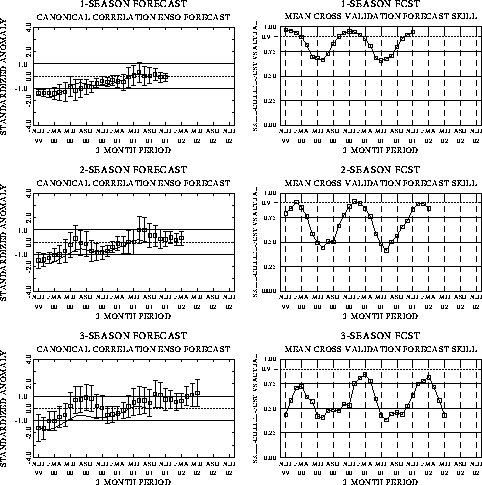
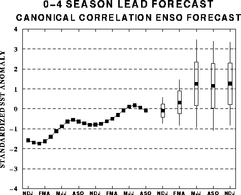
The canonical correlation analysis (CCA) forecast
of SST in the central Pacific (Barnett et al. 1988, Science, 241, 192-196;
Barnston and Ropelewski 1992, J. Climate, 5, 1316-1345), is shown in Figs.
F1 and F2. This forecast is produced
routinely by the Prediction Branch of the Climate Prediction Center. The predictions from
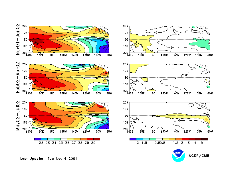
the National Centers for Environmental Prediction (NCEP) coupled ocean/atmosphere model
(Ji et al. 1998, Mon. Wea. Rev, 126, 1022-1034) are presented in Figs. F3 and F4. Predictions from the latest
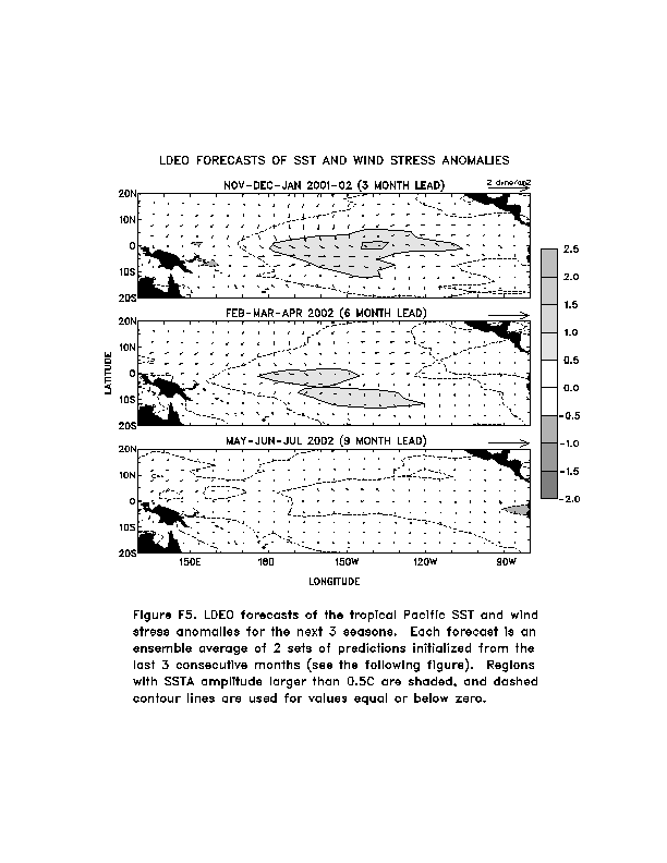
version of the LDEO model (Chen, D., M. A. Cane, S. E. Zebiak, Rafael Canizares and A.
Kaplan, 2000, Geophys. Res. Let., accepted) are shown in Figs. F5 and F6. Predictions using linear
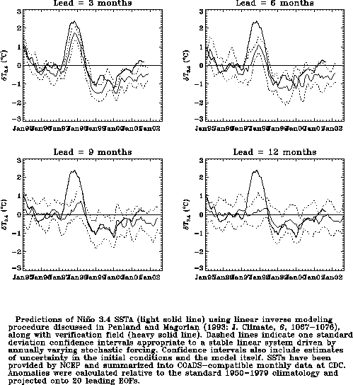
inverse modeling (Penland and Magorian 1993, J. Climate, 6, 1067-1076) are
shown in Figs. F7 and F8.
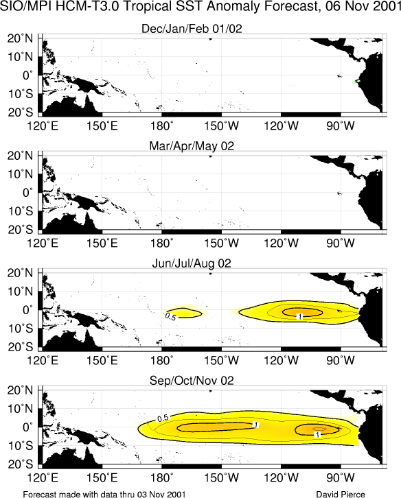
Predictions from the Scripps / Max Planck Institute (MPI) hybrid coupled model (Barnett et
al. 1993, J. Climate, 6, 1545-1566) are shown in Fig. F9.
The CPC and the contributors to the Forecast
Forum caution potential users of this predictive information that they can expect only
modest skill.
Outlook
A gradual transition to warm episode conditions is expected to continue in the tropical
Pacific over the next several months.
Discussion
Most oceanic and atmospheric indices reflected ENSO-neutral conditions during October (Tables
T1, T2). However, during the past
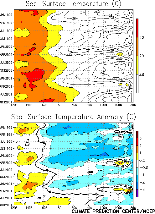
several months sea surface temperatures (SSTs) have become anomalously warm in the central
equatorial Pacific, with anomalies near 1°C just
to the west of the date line (Fig. T9). During the same
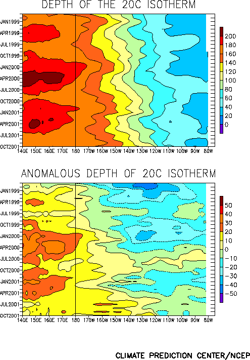
period subsurface temperature anomalies remained positive in the central equatorial
Pacific (Fig. T15), indicating a deeper-than-normal
thermocline. This pattern has been observed immediately prior to the onset of warm
episodes in the past. The anomalously cool SSTs over the eastern equatorial Pacific during
the past few months reflected the amplified annual cycle that has been observed in that
region since 1998 (Fig. T9).
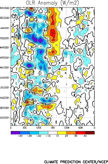
In recent months the pattern of tropical convection [as inferred from anomalous
outgoing longwave radiation (OLR)] has been strongly modulated by tropical intraseasonal
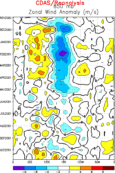
(30-60 day) fluctuations associated with the Madden Julian Oscillation (MJO) (Figs. T11, T12). Low-level wind fluctuations
across the central and western tropical Pacific have been consistent with this activity (Fig. T13). In the past, the convectively active phase of the
MJO has been instrumental in producing low-level westerly wind bursts that are linked to
subsequent oceanic warming in the eastern equatorial Pacific during the onset phase of
warm episodes, especially during the transition seasons (March-May and
September-November). A significant westerly wind burst occurred in the western equatorial
Pacific during mid-October, associated with a particularly strong MJO (Fig. T13). This event resulted in additional deepening of the
oceanic thermocline and an increase in subsurface temperature anomalies in the central
equatorial Pacific by the end of the month. The Climate Prediction Center will closely
monitor the future evolution of the MJO, and any effect that it has on surface and
subsurface ocean temperatures during the next 1-2 months.
The latest statistical and coupled model predictions (Figs. F1,
F2, F3, F4, F5, F6, F7, F8, F9) indicate either weak warm or
near-normal conditions in the equatorial Pacific during the remainder of 2001 and through
the first half of 2002. However, all of these prediction techniques have difficulty in
making skillful forecasts during ENSO transitions. Considering the SST predictions, the
time of year, and the observed oceanic and atmospheric circulation patterns, it seems most
likely that a gradual evolution to warm episode conditions will continue in the tropical
Pacific over the next several months.
Weekly updates of SST, 850-hPa wind, OLR, and the equatorial subsurface temperature
structure are available on the Climate Prediction Center homepage at:
http://www.cpc.ncep.noaa.gov (Weekly Update).
|


