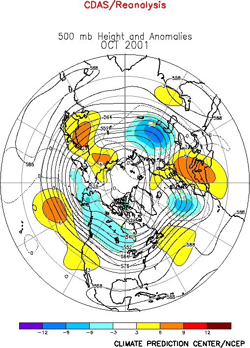
The Northern Hemisphere circulation
during October featured a persistent pattern of above-average 500-hPa heights over
northeastern Asia, the eastern half of North Pacific, the southwestern U.S., the central
and subtropical North Atlantic, and Europe, and below-average heights across Alaska,
Canada, the eastern North Atlantic, and central Russia. (Figs. E10,
E12, E13). It also featured a
large-scale pattern of weak cyclonic 200-hPa streamfunction anomalies in many regions of
the subtropics in both hemispheres (Fig. T22, bottom).a.
North Pacific and North America
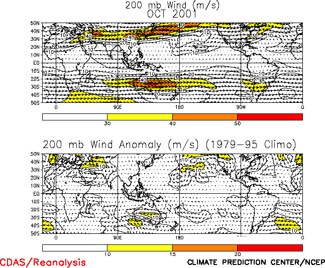
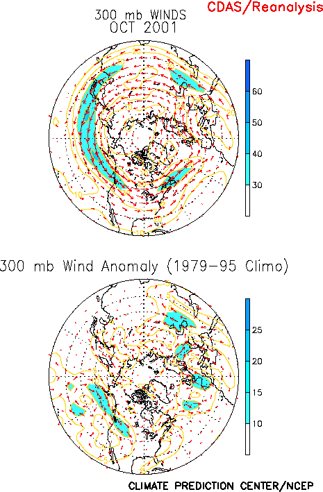
Over the central and eastern North Pacific the north-south dipole pattern of
circulation anomalies in the subtropics and mid-latitudes was associated with a pronounced
split-flow configuration of the East Asian jet stream (Fig. T21,
top). The northern branch of the jet extended well east of normal across the Gulf of
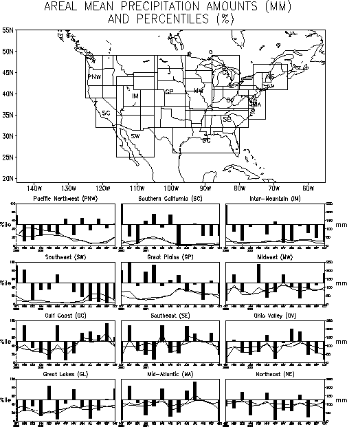
Alaska and northwestern U.S. (Fig. E11, right, T21), where it was associated with increased precipitation (Figs.
E3, E6) and below-average surface
temperatures (Fig. E1). The southern branch reflected a
well-defined subtropical jet stream extending from the date line eastward across northern
Mexico and the southeastern U.S. (Fig. T21, top).
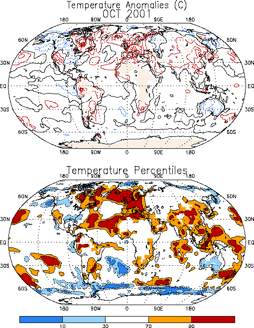
Above average surface temperatures covered the southwestern U.S. and eastern Canada
during October, and below-average temperatures extended across the Gulf Coast states (Fig. E1). Precipitation totals were above average from the
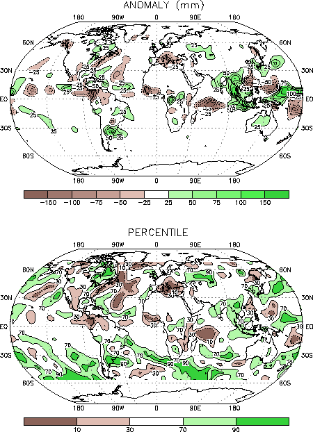
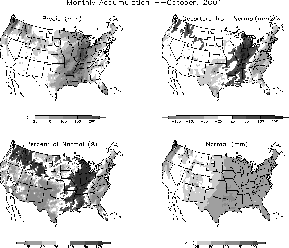
central Gulf Coast northeastward to the Great Lakes during the month (Figs. E3, E6). This marks the first time since
May 2001, and only the second time since February 2001, that the Midwest and Great Lakes
regions recorded above-average monthly precipitation (Fig. E5).
In contrast, October precipitation totals in the northeastern and mid-Atlantic regions
averaged well below the 10th percentile, in association with drier-than-normal
conditions along the entire eastern seaboard of the U.S..
b. North Atlantic and Europe
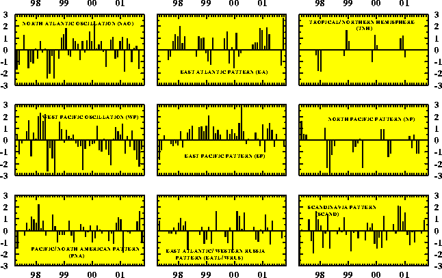
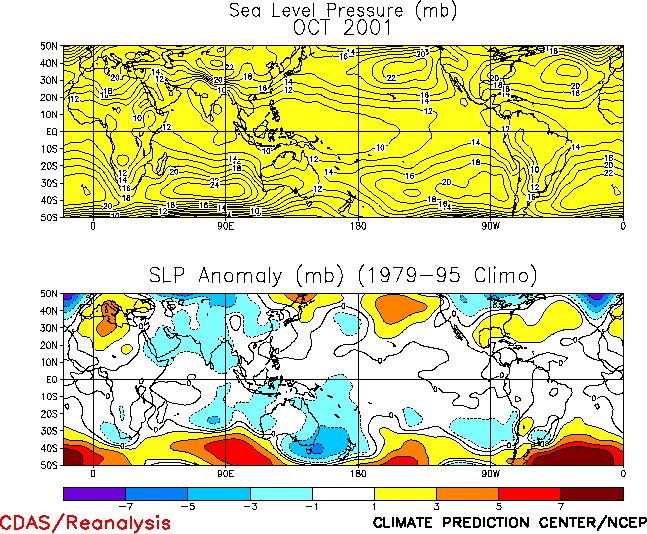
Over the North Atlantic positive 500-hPa height anomalies across the central and
subtropical latitudes during October reflected a strong positive phase of the East
Atlantic teleconnection pattern (Figs. E7, E8
and Table E1). This pattern was accompanied by an
amplification and poleward shift of the mean low-level anticyclonic circulation located
over the central North Atlantic (Figs. T19, T20), with anomalously warm SSTs (Fig. E1,
bottom) found along both the poleward and equatorward flanks of this anomalous
anticyclonic circulation.
Over Europe strong southwesterly flow and above-average 500-hPa heights contributed to
anomalously warm surface temperatures throughout the continent. Beneath the mean
upper-level ridge axis, rainfall totals averaged below the 10th percentile over
southeastern Europe and the central Mediterranean Sea.
2. Southern Hemisphere and ozone hole
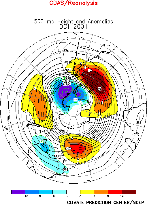
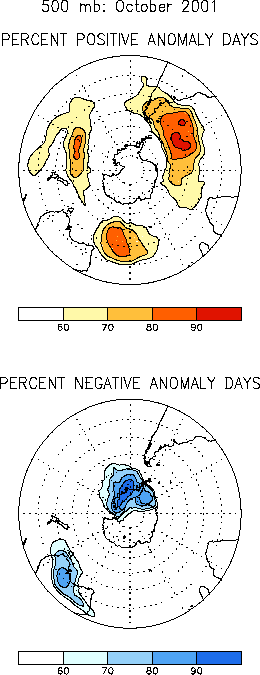
The mean Southern Hemisphere circulation during October again featured
persistent positive 500-hPa height anomalies throughout the middle latitudes, and negative
anomalies over the high latitudes of the South Pacific (Fig. E16,
E18, E19). Below-average heights
also covered southern Australia during the month, in association with an anomalous
equatorward shift of the mean jet stream position to the central portion of the continent
(Fig. T21). This shift was accompanied by a pronounced
northward penetration of anomalously cold air throughout the central and southern portions
of the continent.
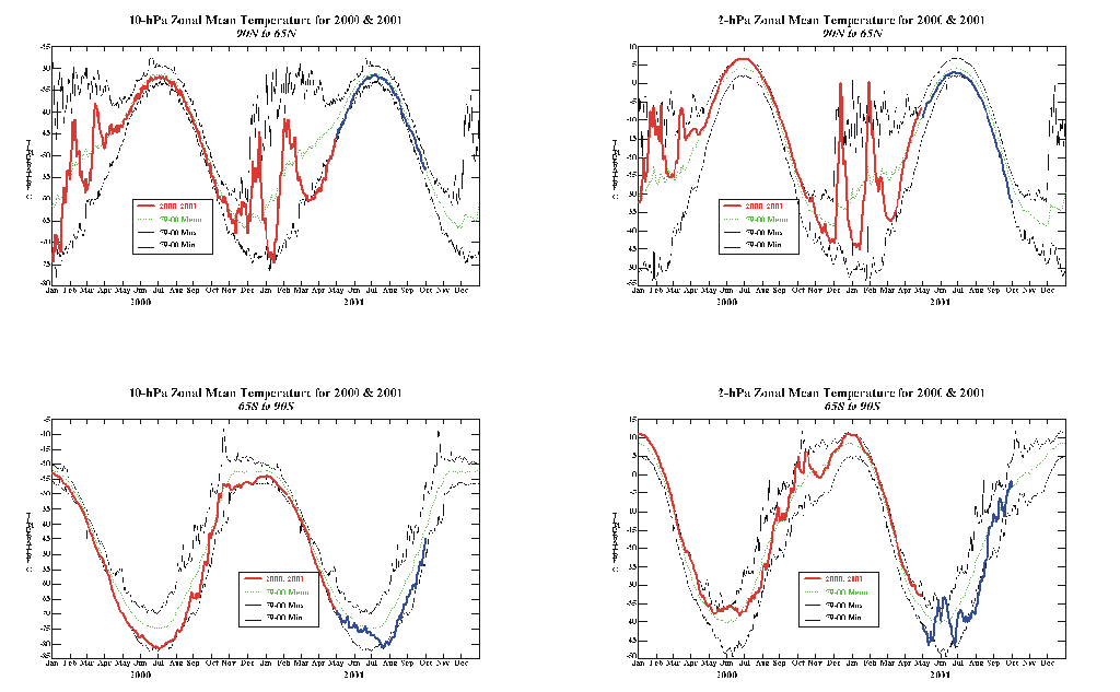
In the lower stratosphere below-average heights (Fig. S1)
and temperatures [averaging more than 8°C below
normal (Fig. S2, bottom)] at 30-hPa and 50-hPa were
observed throughout the polar region and the area extending toward southern Africa. At
10-hPa daily temperatures between 65°S-90°S averaged near the lowest values on record during the
month (Fig. S4). These conditions were associated with an
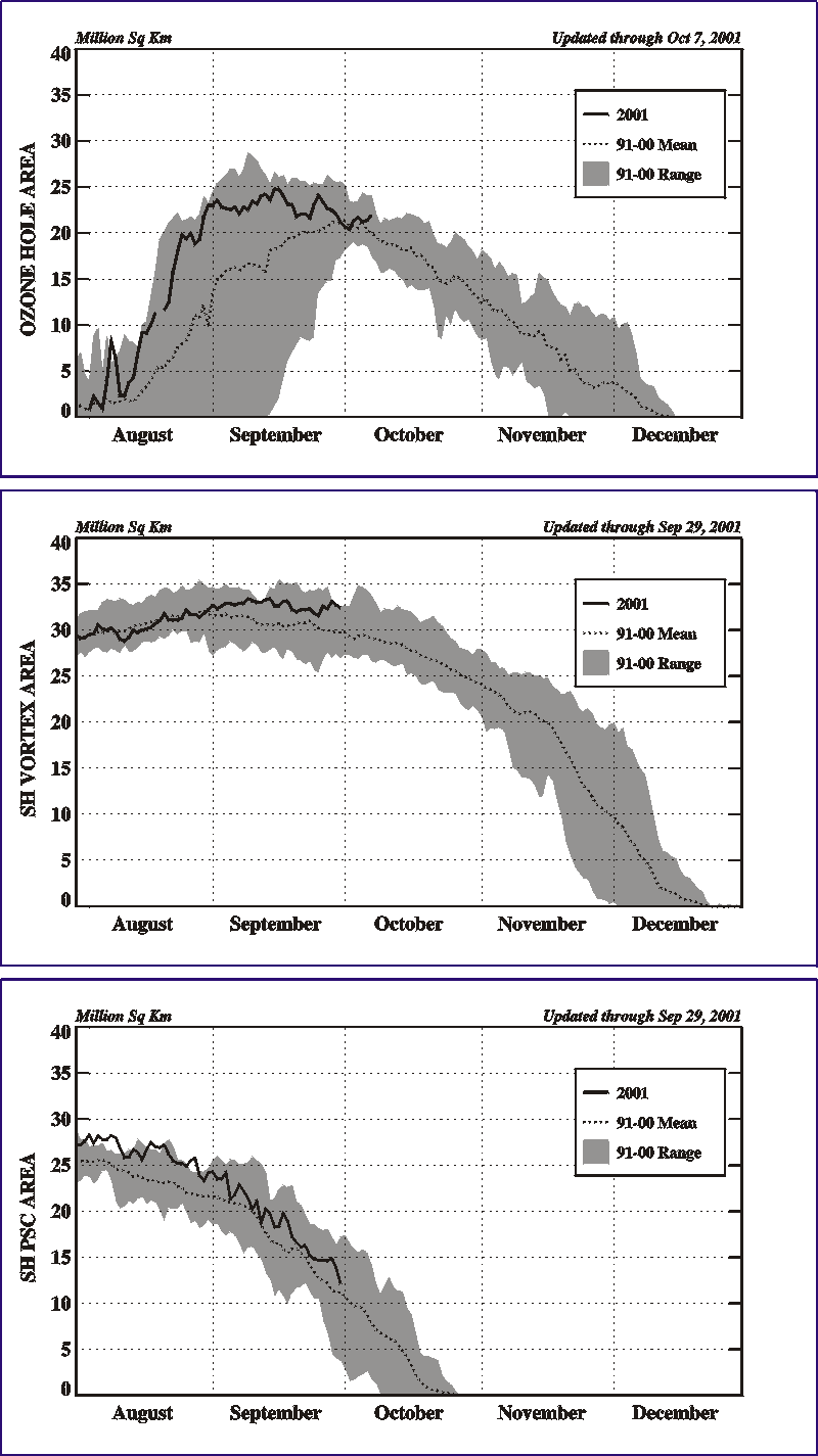
exceptionally large polar vortex (Fig. S8, middle), and
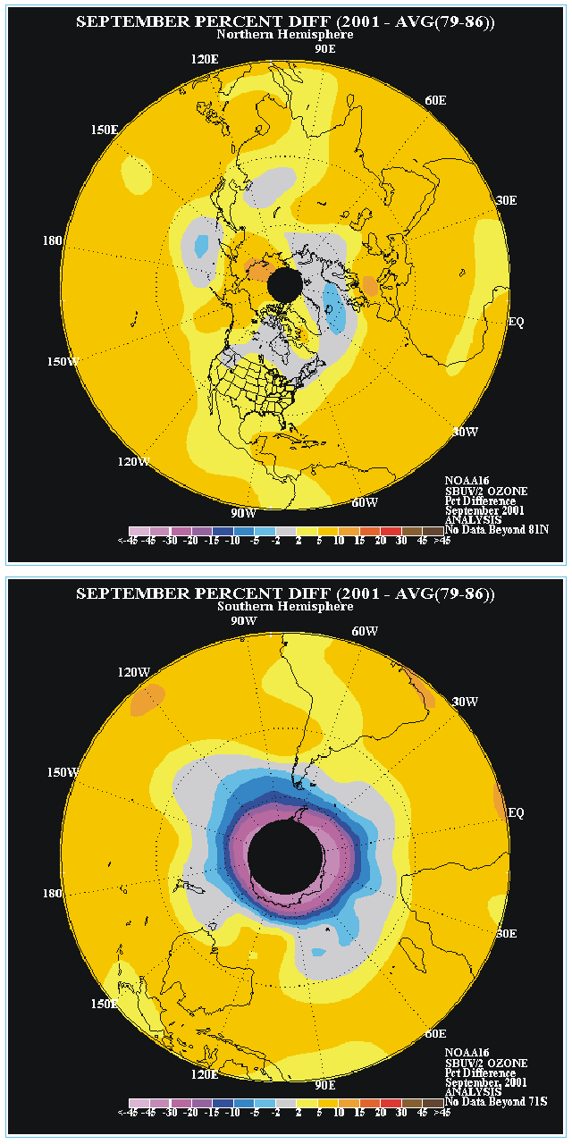
with the third largest ozone hole (shaded region, Fig. S6,
bottom) in the historical record with a coverage of 22 x 106 to 24 x 106
km2 (Fig. S8, top).
The Antarctic ozone hole is defined by total column ozone values less than 220 Dobson
Units (DU). The 2001 ozone hole developed in mid-August, and reached peak strength during
September and October. By the end of October the size of the ozone hole had decreased to
approximately 15 x 106 km2, and by the first week in November it had
decreased further to 12.5 x 10⁶ km2.


