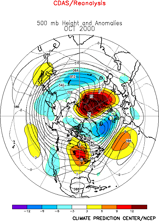
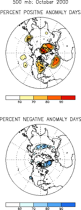
The circulation during October
featured a persistent pattern of above-normal 500-hPa heights centered over south-central
Canada, the mid-latitudes of the eastern North Atlantic, and the Barents Sea, and
below-normal heights over high latitudes of the North Atlantic (Figs. E9, E11). This persistent pattern
contributed to persistent, and in some cases extreme precipitation and temperature
anomalies in many areas of North America and Europe.a. United States
The circulation pattern over North America was dominated by a strong 500-hPa ridge over
south-central Canada and the upper Midwest and troughs along the east and west coasts of
the United States (Fig. E9). This pattern contributed to
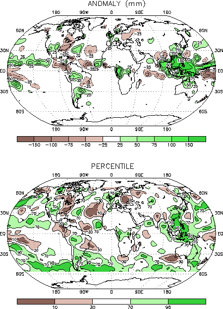
wetter-than normal conditions over the western United States, drier-than-normal conditions
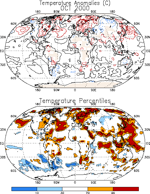
in the Mid-Atlantic and southeastern states, and warmer-than-normal conditions throughout
the center of the country (Figs. E3, E1).
Many areas in South Carolina, North Carolina, Virginia, and Maryland experienced their
driest October on record. This is in marked contrast to September, when much of the East
Coast experienced much wetter-than-normal conditions.
b. Europe and Asia
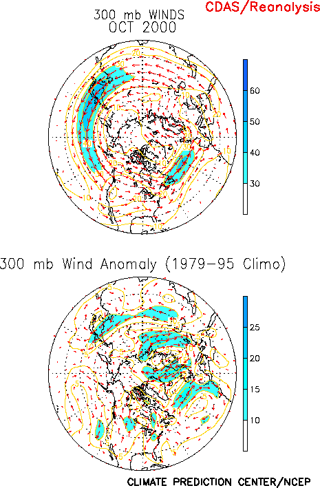
The 500-hPa height anomaly pattern over the North Atlantic was accompanied by
anomalously strong westerlies between 45° and 60°N (Fig. E10),
which contributed to above-normal precipitation over the British Isles and portions of
western Europe (Fig. E3) and above-normal temperatures over
central and eastern Europe (Fig. E1). A series of powerful
storms struck the British Isles and western Europe during the month with high winds and
flooding reported in many countries in the region. In contrast, much drier-than-normal
conditions were observed over eastern Europe.
2. Southern Hemisphere
The 500-hPa height anomaly pattern exhibited very weak anomalies during October.
However, considerable intra-monthly variability was observed in the flow pattern from New
Zealand eastward to the Atlantic. During the first week of October a strong blocking ridge
was located near the Antarctic Peninsula, with a strong split in the jet stream evident
over the eastern South Pacific. The subtropical branch was displaced well to the north
over the western Atlantic and southern Brazil, accompanied by significant rains and cool
conditions over Southeast Brazil. During the following two-three weeks, a blocking pattern
developed over the South Pacific and a strong trough developed and persisted near the
Antarctic Peninsula. During this period the westerlies were concentrated over Central
Argentina, and abnormally warm and dry conditions dominated Southeast Brazil, while
excessive rains and flooding occurred in southern Brazil. The monthly mean anomalous
temperature and precipitation patterns over South America reflect these latter conditions
(Figs. E1, E3).
3. Southern Hemisphere Stratosphere
Stratospheric ozone values were extremely low over Antarctica again during the Southern
Hemispheric winter and spring of 2000, as has been the case in recent years. The area
covered by low total ozone values of less than 220 Dobson Units, defined as the
"ozone hole", was larger in early September 2000 than in early September of any
previous year (Fig. A2.4). The size of the ozone hole
remained larger in September 2000 than in 1999, but rapidly decreased throughout October
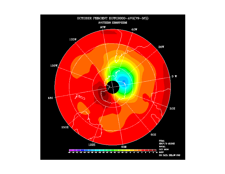
2000. Widespread negative total ozone anomalies, computed with respect to the 1979-1986
base period, were observed during October 2000 (Fig. A2.3).
Anomalies of up to 39 percent below normal are shown over the Atlantic Ocean sector of
Antarctica, with strong negative anomalies also over southern South America. Small
positive anomalies are shown over the Pacific Antarctic sector. This pattern of total
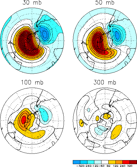
ozone anomalies is consistent, in sign and geographical location, with the pattern of 50
hPa geopotential height anomalies (Fig. A2.1).
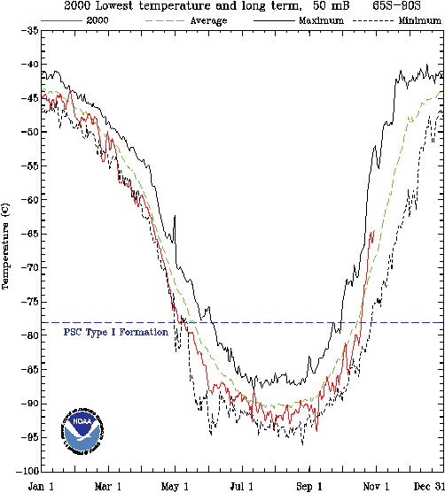
Temperature in the lower stratosphere are closely coupled to ozone through dynamics and
photochemistry. Extremely low stratospheric temperatures (lower than -78°C) over the
Antarctic region contribute to depletion of ozone, since these low temperatures lead to
the presence of polar stratospheric clouds (PSCs). PSCs enhance the production and
lifetime of reactive chlorine, leading to stratospheric ozone depletion. Daily minimum
temperatures over the Antarctic region, 65°S to 90°S at 50 hPa (near 19 km) were lower
than average for most of 2000 (Fig. A2.5), and
were sufficiently low for polar stratospheric clouds to form and contribute to enhanced
stratospheric ozone depletion. During October 2000 lower stratosphere minimum temperatures
increased above the critical PSC temperature, which was associated with the decrease in
size of the ozone hole.


