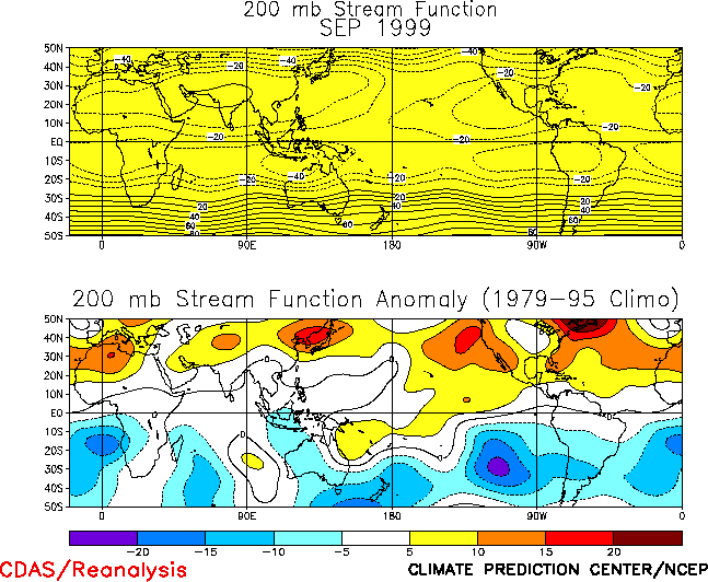
| 1. Northern Hemisphere A strong inter-hemispheric symmetry of anomalous
upper-level circulation features was again evident during September across the lower
latitudes of the Pacific and Atlantic basins (Fig. T22, bottom).
This pattern featured anomalous anticyclonic circulations across the eastern Pacific
eastward to Africa, and anomalous cyclonic circulation anom-alies across the low latitudes
of the western Pacific. Anticyclonic circulation anomalies also persisted across the
middle latitudes of the Northern Hemisphere during the month. All of these features have
prevailed during the June-September period, and are consistent with the ongoing pattern of
anomalous tropical rainfall and tropical convective activity that has persisted during the
period. This pattern of anomalous tropical rainfall included suppressed convection over
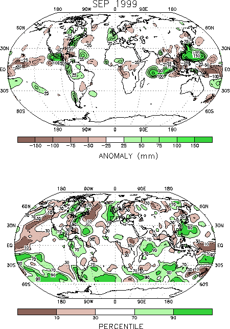
the central equatorial Pacific (Fig. T25), an amplified
south-east Asian monsoon system, above-normal rains across central America, and increased
precipitation across the African Sahel region.
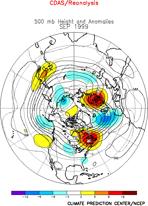
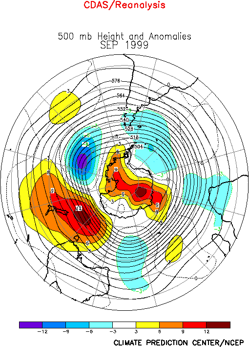
North America
Much of the United States was influenced by a large-scale, upper-level trough during
September (Fig. E9), which contributed to significantly
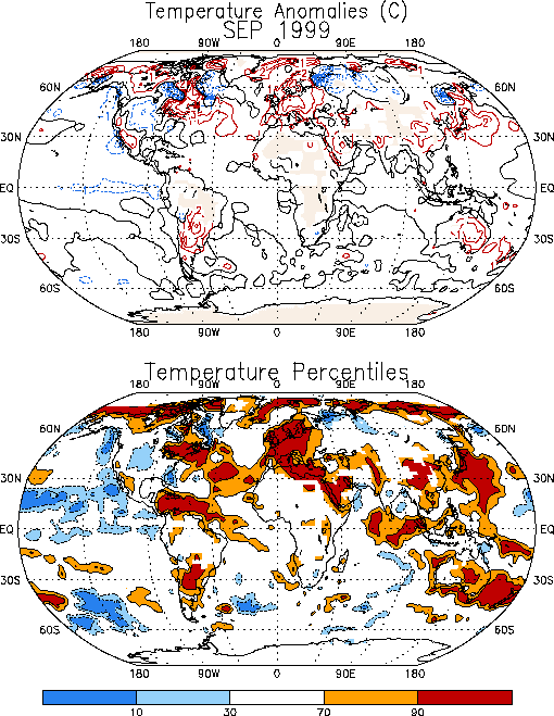
above-normal temperatures over the northeastern United States and southeastern Canada and
to below-normal temperatures over the Plains states (Fig. E1).
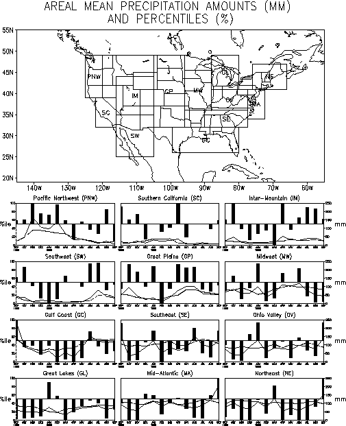
This circulation pattern, together with Tropical Storm Dennis and Hurricane Floyd
contributed to extremely heavy rainfall along the entire eastern seaboard from the
Carolinas to the maritime provinces of Canada (Fig. E3). In
fact, eastern North Carolina experienced record flooding in association with extreme
rainfall totals (reaching 500 - 750 mm) linked to landfalling Hurricane Floyd. In
contrast, the region near and west of the trough axis, which included most of the
midwestern United States, experienced drier-than-normal conditions (Figs. E3, E5).
This circulation pattern is in marked contrast to the pronounced upper-level ridge
which dominated most of the country during August, and which contributed to significantly
drier-than-normal conditions and severe drought conditions over large portions of the
eastern United States.
b. Europe/ Asia
Most of Europe experienced significantly above-normal temperatures during September (Fig. E1), with temperatures above the 90th percentile
observed throughout the region. In southern and central Europe, this warmth represents a
continuation of extremely warm conditions that have prevailed during the last several
months. Extremely wet conditions were also observed across western Europe during
September, with totals exceeding the 90th percentile throughout the region.
Farther east, anomalously dry conditions were observed over eastern Europe and western
Russia.
These anomalous temperature and rainfall patterns were linked to a large-amplitude
anomalous circulation at upper levels, which featured a trough just west of Great Britain
and a strong ridge extending southward from Scandinavia to the area west of the Black Sea.
Also, the continued excessive warmth across southern Europe (and northern Africa) was
again linked to the persistence of an anomalous anticyclonic circulation (Fig. T22, bottom) throughout the region at upper levels.
2. Southern Hemisphere
The Southern Hemisphere circulation during September (Fig. E15)
featured above-normal heights over southeastern Australia and New Zealand, across most of
Antarctica, and over the central Indian Ocean, and below-normal heights over the high
latitudes of the eastern South Pacific, the high latitudes of the South Atlantic, and
southern Africa. In the Australia/ New Zealand sector, the above-normal heights were
associated with abnormally warm surface temperatures (Fig. E1),
with large portions of eastern Australia recording values above the 70th
percentile and most of New Zealand recording values above the 90th percentile.
These circulation and temperature patterns conditions were also prevalent during August
across the Australia/ New Zealand sector.
In South America, most of cental Argentina and southeastern Brazil experienced a
continuation of anomalously warm (Fig. E1) and dry
conditions (Fig. E3) during the month, while southern
Argentina again experienced extremely wet conditions. This overall pattern has been linked
to increased upper-level westerly winds (Fig. T21, bottom)
and enhanced storminess across the southeastern South Pacific and southern South America
during both August and September, and with an overall poleward displacement of the main
frontal boundary away from central Argentina and southeastern Brazil.
|


