The
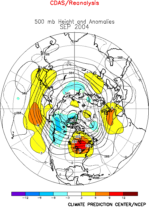
500-hPa circulation during September featured above-average heights in the
middle latitudes and below-average heights over western North America (Fig.
E9). The main persistent positive anomalies were observed across the
central North Pacific, the eastern half of Canada, and southwestern Europe
(Fig. E11). This circulation was associated with below-average
temperatures over western
Canada, and above-average temperatures over eastern
Canada
and the northeastern
United States
(Fig. E1). Elsewhere, temperatures were above average throughout
Europe, southeastern Asia and India, and the African Sahel and Sudan
regions.
The main
positive precipitation anomalies during September were observed over the
eastern United States, where near-record totals were associated with three
landfalling hurricanes. The main negative precipitation anomalies during
the month were observed in the midwestern United States, and across the
African Gulf of Guinea region. Elsewhere, through September 2004 the
Atlantic hurricane season was well above normal and the East Pacific
hurricane season was considerably below normal.
a. North America
Over North
America the mean circulation during September featured a persistent
upper-level trough over western Canada and Alaska, and a persistent ridge
over the eastern half of Canada and the northeast quadrant of the United
States. (Figs. E9, E11). The surface temperature anomalies were in
phase with the upper-level height anomalies (Fig. E1). This anomaly
pattern is opposite to that observed during April-August, when extremely
warm temperatures covered Alaska, and anomalously cold temperatures
prevailed across central and eastern North America.
During
September the eastern U.S. experienced well above-average precipitation (Fig.
E3) and increased storminess (Fig. E13) in response to three
landfalling hurricanes. Hurricane Frances hit the east coast of Florida as a
Category-2 storm on 5 September, Major Hurricane (MH) Ivan hit Alabama as a
Category-4 storm on 16 September, and MH Jeanne hit the east coast of
Florida as a Category-3 storm on 26 September.
b. Atlantic hurricane season
The 2004
Atlantic hurricane season is one of the most active since 1945, with twelve
tropical storms (TS), eight hurricanes, and six major hurricanes by the end
of September. Since 1995 eight of ten hurricane seasons have been above
normal, compared to only three during the previous 25-years (1970-1994).
During
September 2004 four hurricanes, three of which became major hurricanes,
developed in the tropical Atlantic. Eight tropical storms formed during
August, with five becoming hurricanes and an August record of three becoming
major hurricanes.
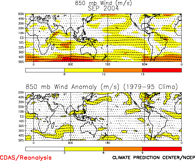
Over the
tropical Atlantic the above-normal Atlantic hurricane season was associated
with 1) an amplified subtropical ridge at upper levels (Fig. T22), 2)
reduced vertical wind shear in response to enhanced upper-level easterlies
and reduced lower-level easterlies (Figs. T20, T21), 3) enhanced
cyclonic shear at 850-hPa along the equatorward flank of the African
easterly jet, which favors hurricane development from tropical disturbances
moving westward from the African coast (Fig. T20), and 4) above
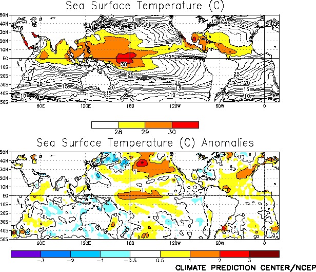
average sea-surface temperatures (Fig. T18). These conditions have
been associated with the increased hurricane activity since 1995 (Bell et
al., Bull. Amer. Meteor. Soc., May 2004).
For
August-September 2004 combined, six named storms made landfall in the United
States. In addition to the three September landfalls (section 1a), TS Bonnie
hit the Florida Panhandle on 12 August, major hurricane Charlie hit the west
coast of Florida as a Category-3 storm on 13 August, and TS Gaston hit South
Carolina on 30August. In the
past three years seventeen named storms have made landfall in the U.S. (6 in
2002, 5 in 2003, and 6 in 2004), with thirteen hitting the Gulf Coast region
(5 in 2002, 5 in 2003, and 3 in 2004).
c. East Pacific hurricane season
The East Pacific hurricane season again featured
considerably below-normal activity during June-September, which reflects the
generally suppressed activity observed in that region since 1995. By the end
of September, the season had produced only ten named storms, with five
becoming hurricanes and two (Darby and Javier) becoming major hurricanes.
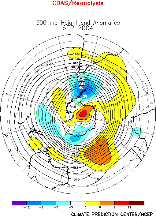
2. Southern Hemisphere
The 500-hPa circulation
during September featured above-average heights across the Indian Ocean,
south of Australia, the high latitudes of the central South Pacific, and the
polar region, and below-average heights south of South America (Fig. E15).
At lower latitudes anticyclonic streamfunction anomalies prevailed from the
central South Pacific eastward to southern
Africa
, and cyclonic anomalies were observed over the
Amazon
Basin
and upstream of
Australia
(Fig. T22). In Australia, the anomalous upper-level trough brought
increased cloud cover and below-average temperatures to the western part of
the continent.
South America
In the Tropics the upper-level circulation reflected a weakening of
the “monsoon” ridge, and was consistent below-average precipitation in
the northern Amazon Basin and Central America. In both regions
June-September precipitation totals were below the 10th
percentile of occurrences. The Amazon Basin also experienced warmer than
normal conditions during the period, with mean temperatures ranging from 1°-2°C
above average.
In the
middle latitudes the anomalous anticyclonic circulation at upper levels was
associated with reduced jet stream winds, along with a reduction in the
number of synoptic-scale troughs and major cold frontal passages east of the
Andes Mountains. These conditions contributed to warmer than normal
conditions across extratropical South America.


