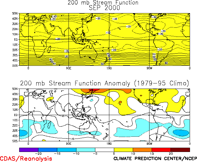
The circulation during September
featured a persistent pattern of above-normal heights from eastern Russia and northeastern
China eastward across the high latitudes of the North Pacific, and over Scandinavia, and
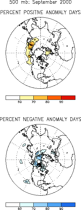
below-normal heights throughout the polar region (Figs. E9, E11). Over Asia and the North Pacific, this anomaly pattern was
accompanied by anomalously weak westerlies across China, and along and south of the core
of the East Asian jet stream. Elsewhere, the monthly mean height anomalies in the
extratropics were quite small, and reflected the lack of persistence of circulation
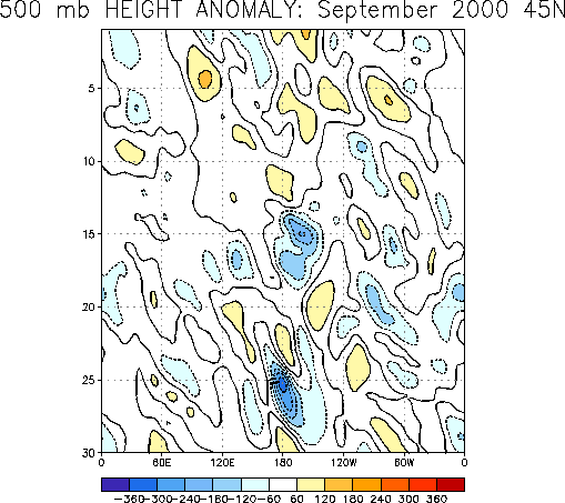
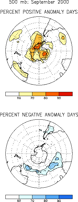
anomalies during the month (Fig. E12). Despite this
variability of the circulation features during the month, many continental regions
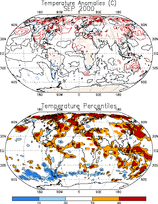
experienced significant monthly-mean temperature and rainfall anomalies. The primary
regions of anomalously warm temperatures included the southwestern United States, eastern
Canada, western Europe, the eastern Mediterranean Sea, and large portions of southern
Russia (Fig. E1), while anomalously cool conditions covered
the eastern seaboard of the United States, southern Alaska, and isolated areas of eastern
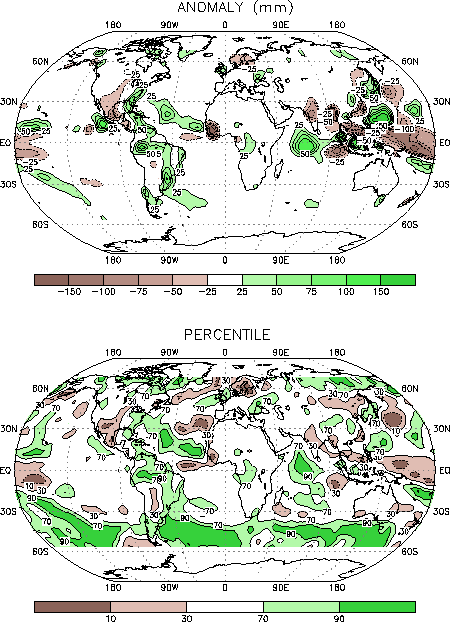
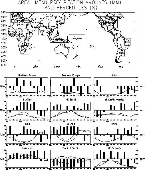
Europe. The prominent precipitation anomalies during September reflected a continuation of
significantly below-average rainfall over the southwestern United States (Fig. E3), above-average rainfall across the eastern seaboard
of the United States, and below-average rains across southeastern Asia.
a. United States
A time-longitude section of 500-hPa height anomalies along the 45 N latitude band (Fig. E12) illustrates the considerable variability exhibited
by the large-scale flow pattern across the United States during September. As a result of
this variability, many regions were impacted by both large-scale ridges and troughs during
the month. Nonetheless, the prominent monthly-mean temperature and precipitation anomalies
were consistent with the mean positions of the large-scale ridges and troughs. In
particular, the mean large-scale ridge over the middle of the country contributed to
exceptionally warm (Fig. E1) and dry (Figs. E3, E5) conditions in the southwestern
U.S. and much of Mexico, with some areas experiencing temperatures in the upper 90th
percentile and rainfall in the lowest 10th percentile. The southwest and northwestern
Mexico have recorded significantly below-average rainfall since July (Fig. E5), with above-average rains during this year’s
monsoon season occurring only in June. Drier-than-normal conditions also extended
northeastward through the upper-level ridge axis into Minnesota during September, with the
Great Plains region experiencing significantly below-average rainfall for the second
consecutive month. Farther east, the Midwest region experienced near-average rainfall
during the month. Significantly below-average precipitation has plagued both of these
regions for more than a year.
In contrast, the eastern seaboard experienced cooler and wetter-than-average conditions
during September, as the region was situated in an area of large-scale ascending motion
immediately downstream of the mean upper-level trough axis. In the Southeast and Gulf
Coast regions above-average rains were observed during September for the first time in
more than a year (Fig. E5). Farther north, the Mid-Atlantic
and Northeast regions experienced a third consecutive month of above-average rains.
b. Europe and Asia
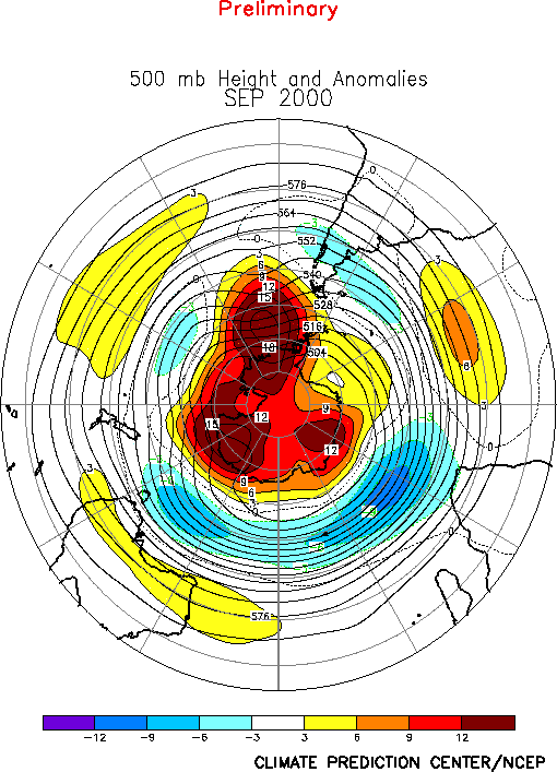
A large amplitude ridge dominated Scandinavia and eastern Europe during September,
while an upstream trough impacted northwestern Europe and Great Britain (Fig. E9). These circulation features brought above-average
surface temperatures to northern Scandinavia, most of Europe, and Great Britain, and
above-average rainfall to Great Britain.
Farther south, above-average temperatures also covered the eastern half of the
Mediterranean Sea, and the area extending eastward across southern Russia to the Caspian
Sea. This warmth was associated with anomalous southwesterly flow at upper levels in the
area downstream of the mean upper-level trough axis (Figs. E9, T22 top).
In eastern Asia, a persistent pattern of above-average heights over eastern Siberia was
accompanied by reduced upper-level westerly winds across China. These conditions were
associated with a reduced strength of storms moving through the westerlies north of the
Tibetan Plateau, and also with a reduced southward penetration of the accompanying cold
fronts into the area east of the Plateau and particularly into southeastern Asia. The
southward penetration of frontal systems into southeastern Asia is a known trigger for
heavy convective activity, and the lack of these systems during September likely
contributed to the significantly below-average rainfall observed in that area during the
month (Figs. E3, E4).
2. Southern Hemisphere
The 500-hPa height anomaly pattern exhibited strong zonal symmetry during September in
the subtropics, the middle latitudes, and the polar region (Fig.
E15). In particular, positive height anomalies covered the subtropics and the
lower middle latitudes (see also Fig. T22 bottom), as well
as the polar region, while negative height anomalies dominated the upper middle latitudes.
The most persistent features of this anomaly pattern were above-average heights over
southern Australia, the central South Pacific, Antarctica, and the high latitudes of the
eastern South Pacific, and below-average heights across the high latitudes of the Indian
Ocean and in the area south of Australia (Fig. E17).
This pattern reflected a continuation of recurring blocking activity over the high
latitudes of the eastern South Pacific, which again contributed to an abnormal influx of
cold air into Argentina and southeastern Brazil (Fig. E1).
Similar conditions also prevailed during July and August, which has resulted in portions
of southeastern Brazil recording temperatures below the 30th percentile for the third
consecutive month.
In Australia above-average temperatures and isolated regions of below-average rainfall
covered the south during September, in association with a poleward shift of the westerlies
to the area south of the continent. This poleward shift of the westerlies was also
consistent with above-average rainfall over the southern oceans in the vicinity of 40°N.


