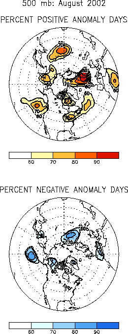
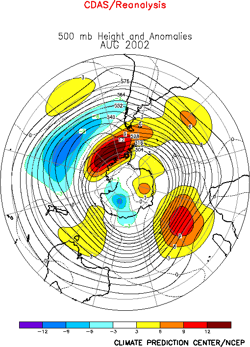
| The 500-hPa circulation during August
featured above-average heights extending from the northeastern United States to
Scandinavia, over central Asia, and across eastern Siberia, and below-average heights
across the central North Pacific, southern Europe, central Russia, and eastern China (Figs.
E10, E12). In the subtropics
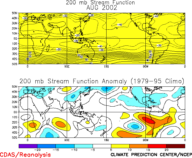
cyclonic streamfunction anomalies extended eastward from the central North Pacific to
southeastern Asia (Fig. T22, bottom), with similar
anomalies also evident in the Southern Hemisphere. This overall anomaly pattern is
consistent with the strengthening El Nińo episode (Fig. T18),
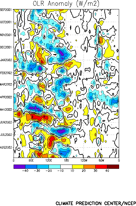
and with the eastward propagation of the ascending phase of the MJO across the tropical
Pacific during the month (Figs. T11, T12). Prominent
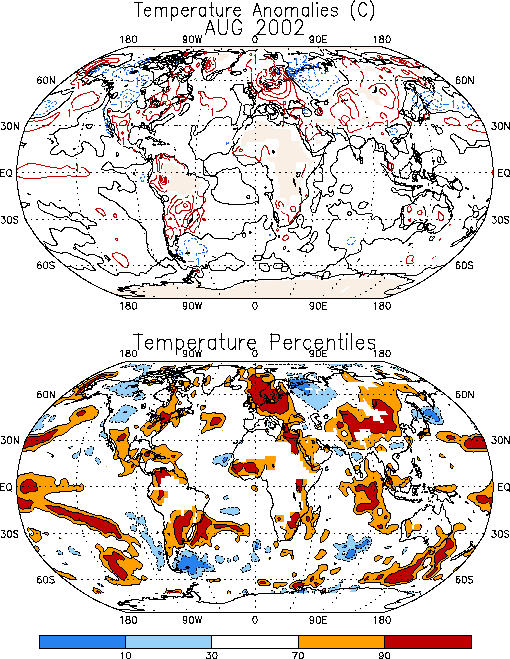
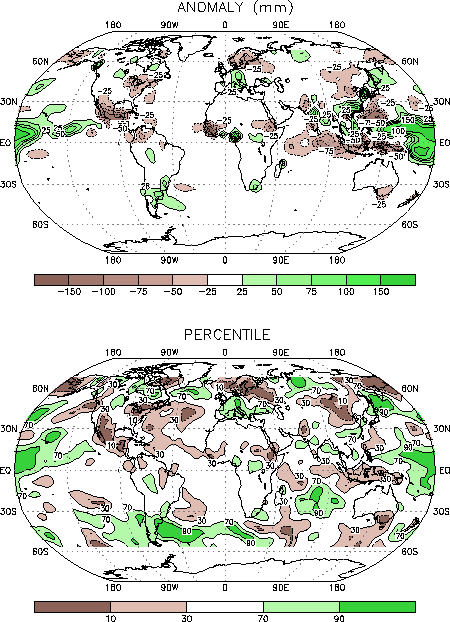
temperature (Fig. E1) and precipitation (Figs. E3, E4, E5)
anomalies during August included a continuation of warmer and drier than normal
temperatures over the northeastern and southwestern United States, northern Europe, and
Mongolia, and a continuation of exceptionally heavy rainfall across southern Europe and
southeastern China.
a. North America
Above-normal 500-hPa heights covered the
northeastern United States for a third consecutive month in association with an eastward
expansion of the mean summertime ridge. During August this circulation was associated with
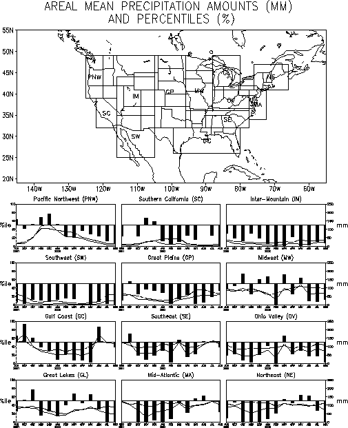
a continuation of exceptionally warm and dry conditions across the region, with
temperature departures exceeding the 90th percentile (Fig.
E1) and rainfall departures falling in the lowest 10th percentile of
occurrences (Fig. E3). Regionally, significantly
below-average rainfall was again observed in the Great Lakes, Ohio Valley, and Northeast
regions (Fig. E5) during August. Precipitation in the Ohio
Valley has been below normal since June 2001.
Below-average rainfall also persisted in the Inter-Mountain and Southwest regions
during August (Figs. E3, E5).
Precipitation has been below normal in these regions since June 2001 (Fig.
E5).
b. Europe
Most of northern Europe, western Russia, and eastern Asia experienced a continuation of
well above-average surface temperatures during August (Fig. E1)
in association with anomalously strong ridges at upper levels (Fig.
E10). Monthly mean temperatures averaged 2-4°C above normal in these areas and
exceeded the 90th percentile.
Below-normal rainfall was observed across northern Europe (Fig.
E4) during August, while well-above-normal rainfall continued across the southern
and central portions of the continent. This dipole pattern of rainfall anomalies was
associated with a pronounced split-flow in the 500-hPa height field over the eastern North
Atlantic (Fig. E10), which featured a persistent
upper-level ridge across Scandinavia and northern Europe within the northern branch of the
split flow, and enhanced jet stream winds across northern Africa and southern Europe
within the southern branch.
C. China/ Mongolia
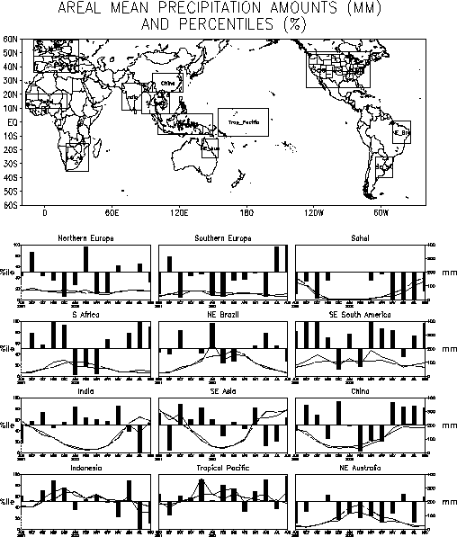
Above-average rainfall continued in southeastern China for a fourth consecutive month (Fig. E4), resulting in additional flooding in the Yangtze
River Valley. This excessive convective rainfall has been associated with a very
persistent upper-level trough situated over central China in association with an
anomalously weak Asian monsoon ridge (Fig. T22).
Farther north well-below-average rainfall was again observed over large portions of
Mongolia, in association with a southward shift of the main storm track toward China. The
climatological rainy season for Mongolia is June-August. During 2002 June-August rainfall
totals were less than 25% of normal over most of the country, which is well below the 10th
percentile of occurrences. Mongolia also recorded considerably below-average rainfall
during the 2001 rainy season, and has not recorded ample rainfall since 1998.
2. Southern Hemisphere
The upper level circulation during August
featured cyclonic (i.e., positive) streamfunction anomalies in the subtropics from the
eastern South Pacific eastward to the central Indian Ocean (Fig.
T22 bottom), in association with strengthening El Nińo conditions (Fig. T18) and intra-seasonal activity linked to the MJO (Figs.
T11, T12). In the extratropics
above-average heights were observed over the high latitudes of the eastern South Pacific,
the central Atlantic Ocean, and the central Indian Ocean (Fig. E16),
and below-average heights were observed across the middle latitudes of the central and
eastern South Pacific.
This circulation was associated with a pronounced eastward extension of the South
Pacific jet stream to approximately 90°W (Fig. T21 top),
and with a corresponding eastward displacement of the jet exit region to the eastern South
Pacific. Increased storminess and enhanced rainfall were evident across southern South
America along the poleward flank of this anomalous jet exit region, while exceptionally
warm surface temperatures were observed over central South America along its equatorward
flank. |
