The canonical correlation analysis
(CCA) forecast of SST in the central Pacific (Barnett et al. 1988, Science, 241,
192-196; Barnston and Ropelewski 1992, J. Climate, 5, 1316-1345), is shown
in Figs. F1 and F2. This forecast
is produced routinely by the Prediction Branch of the Climate Prediction Center. The
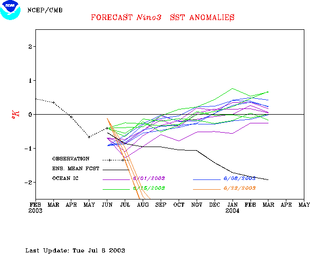
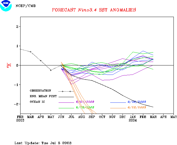
predictions from the National Centers for Environmental Prediction (NCEP) coupled
ocean/atmosphere model (Ji et al. 1998, Mon. Wea. Rev, 126, 1022-1034) are
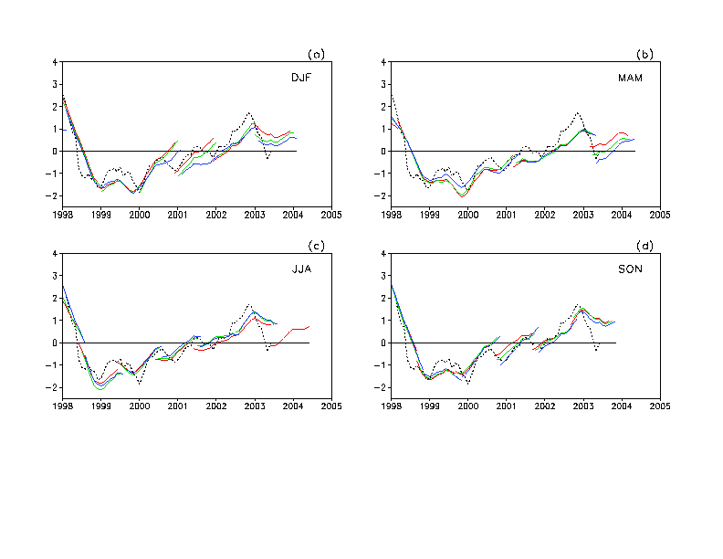
presented in Figs. F3 and F4a, F4b. Predictions from the Markov model (Xue,
Y. et al. 2000: ENSO prediction with Markov model: The impact of sea level. J. Climate,
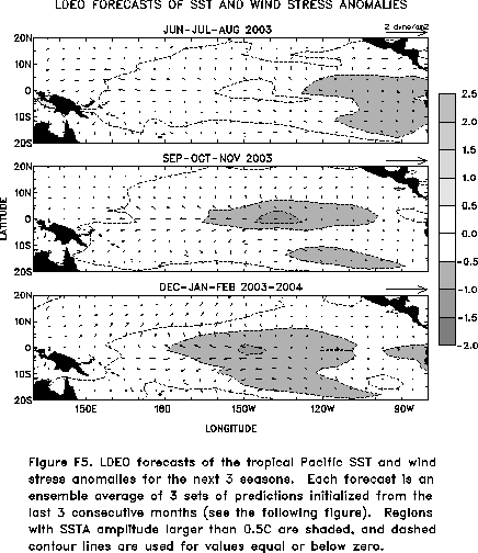
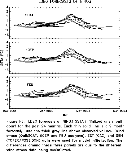
13, 849-871) are shown in Figs. F5 and F6.
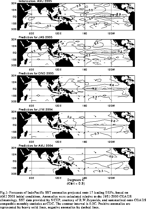
Predictions from the latest version of the LDEO model (Chen,
D. et al. 2000, Geophys. Res. Let., 27,
2585-2587) are shown in Figs. F7 and F8.
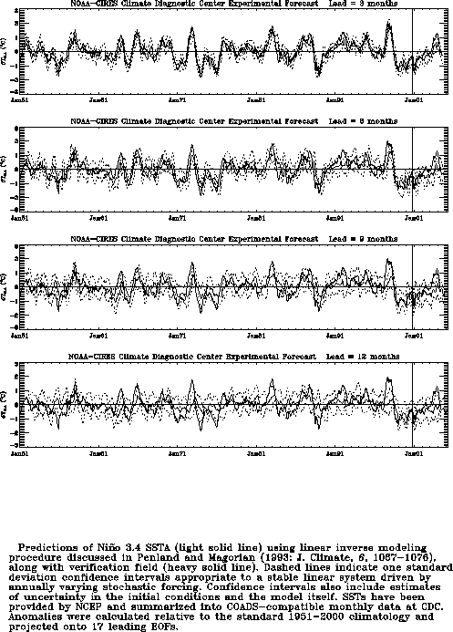
Predictions using linear inverse modeling (Penland and Magorian 1993, J. Climate, 6,
1067-1076) are shown in Figs. F9 and F10.
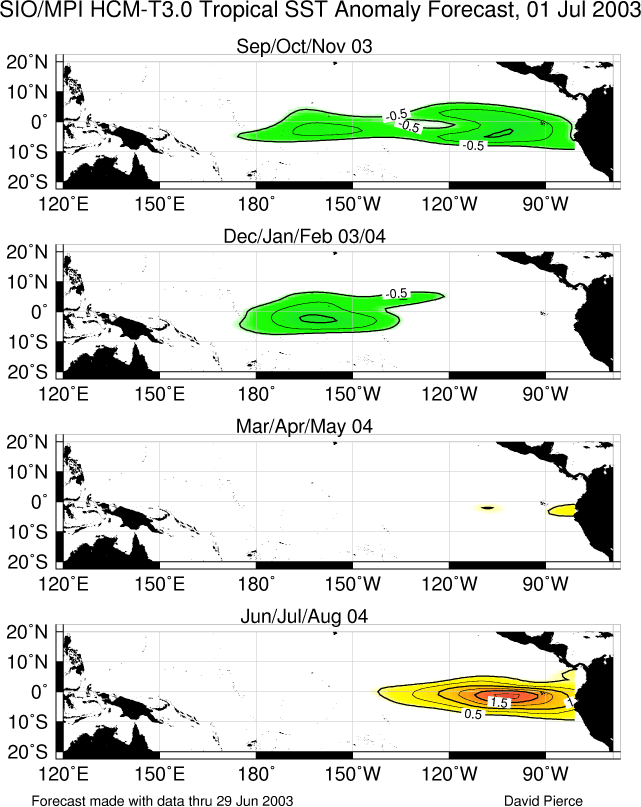
Predictions from the Scripps / Max Planck Institute (MPI) hybrid coupled model (Barnett et
al. 1993, J. Climate, 6, 1545-1566) are shown in Fig. F11. Predictions from the ENSO-CLIPER statistical model
(Knaff, J. A. and C. W. Landsea 1997, Wea. Forecasting, 12, 633-652) are
shown in Fig. F12. Niño
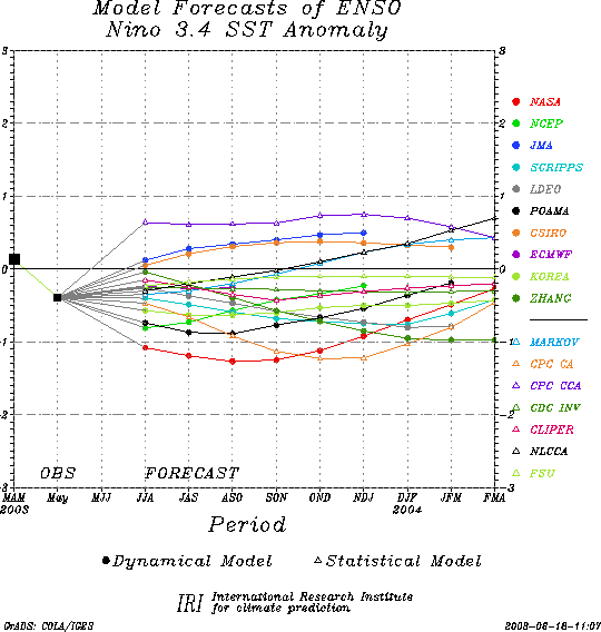
3.4 predictions are summarized in F13,
which is provided by the Forecasting
and Prediction Research Group of the IRI.
The CPC and the contributors to the Forecast Forum caution potential users of
this predictive information that they can expect only modest skill.
Outlook
Based on current conditions and recent observed
trends, it is most likely that near neutral conditions will occur in the
tropical Pacific during the last half of 2003.
Discussion
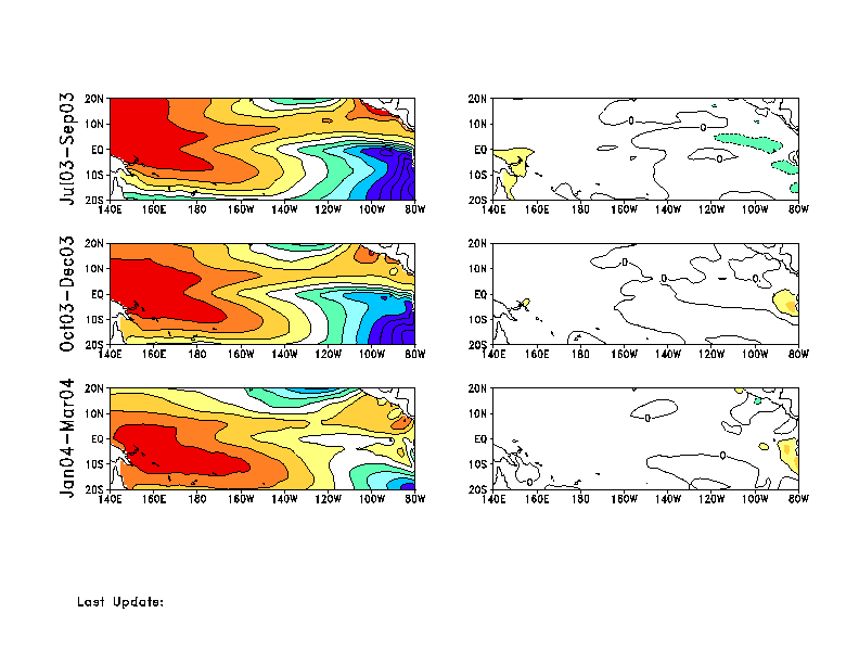
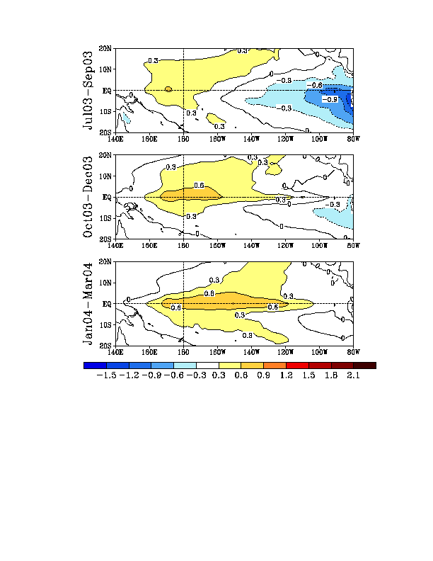
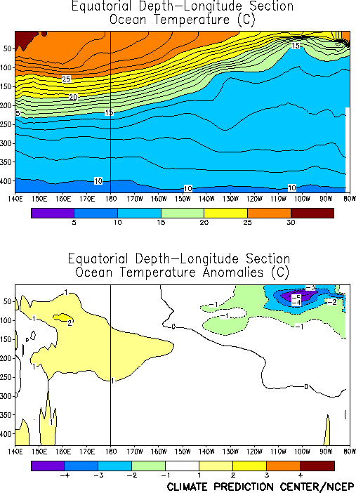
Cooler-than-average surface (Fig. T18)
and subsurface (Fig. T17) water
temperatures were observed in the east-central and eastern equatorial
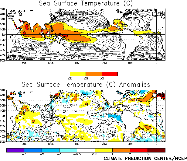
Pacific during June 2003. However, negative sea-surface temperature
anomalies weakened across the central and eastern equatorial Pacific
during the month (Fig. T9), consistent
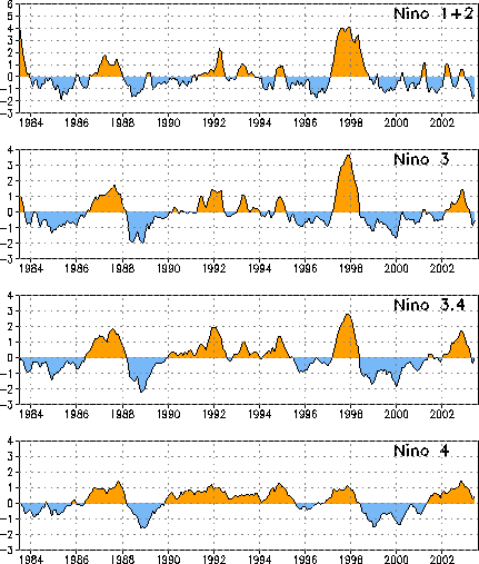
with an upward trend in SST anomalies in all of the NiZo
regions (Fig. T5, Table
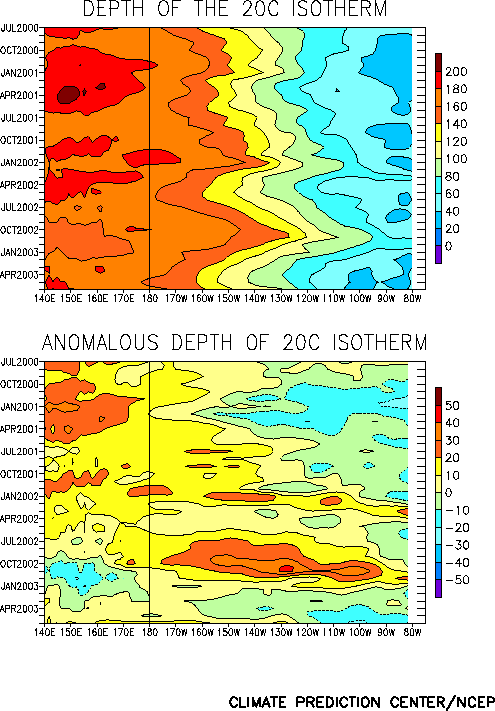
T2). Since late May positive equatorial upper-ocean temperature
departures have increased in magnitude in the western Pacific and spread
eastward into the central and eastern Pacific (Fig.
T15). This evolving subsurface pattern is associated with an
eastward propagating oceanic Kelvin wave, resulting from a period of
weaker-than-average low-level easterlies in the central equatorial
Pacific that occurred during late May. These recent trends in surface
and subsurface ocean temperature departures do not support the
development of La NiZa
conditions during the next few months.
The latest statistical and coupled model forecasts indicate
considerable uncertainty for the next several months (Figs. F1,
F2, F3,
F4a, F4b, F5, F6, F7,
F8, F9, F10,
F11, F12, F13).
However, the majority of the forecasts indicate near neutral conditions
(NiZo 3.4 SST anomalies
between -0.5EC and +0.5EC)
during the last half of 2003. This is consistent with current conditions
and recent observed trends.


