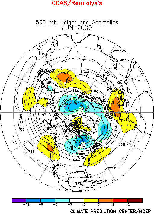
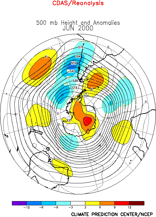
The circulation during June featured above-average
heights across the east-central North Pacific and the western United States, over the
northeastern United States, over the eastern North Atlantic and Europe, and across central
Russia (Fig. E9). The circulation also featured
below-average heights over central Canada, the polar region and the higher latitudes of
the North Atlantic. In the subtropics and lower mid-latitudes, there remains considerable
symmetry of the upper-level circulation anomalies in both hemispheres (Fig. T22, bottom). During June, this pattern was dominated by
anticyclonic circulation anomalies extending across both hemispheres in the 20°-50°
latitude band.
Since mid-1998 the most notable aspects of this pattern have been anticyclonic
anomalies extending eastward in the Northern Hemisphere from the Atlantic Ocean to Asia
and in the Southern Hemisphere from the Atlantic Ocean eastward to Australia. This pattern
is consistent with ongoing La Niña conditions, and is the leading mode of atmospheric
variability on both the interannual and interdecadel time scales.
a. North America
Above-average heights covered both the western and northeastern United States during
June, and below-average heights extended northeastward from the northern Plains states to
northeastern Canada (Fig. E9). This anomaly pattern was
accompanied by enhanced northwesterly flow into the northern and central Plains states,
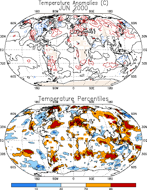
which contributed to abnormally cool temperatures throughout the region (Fig. E1), as well as across central Canada. In contrast,
temperatures in the southwest remained above-average (1°-2°C) during the month, in
association with the positive height anomalies to the north.
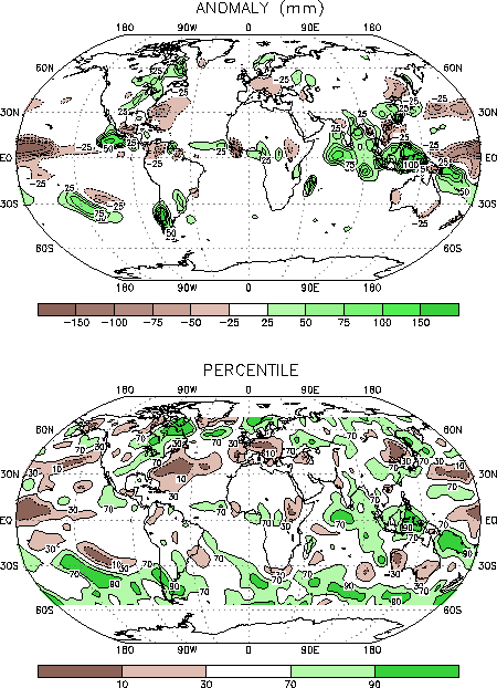
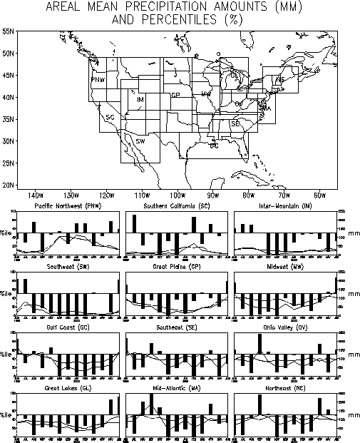
The anomalous circulation during June also contributed to enhanced precipitation over
central Canada, the Great Lakes, the Midwest, and the Southwest (Fig.
E3, bottom). In the United States each of these areas had previously recorded
significantly below-average precipitation totals during the past year. For example, the
Midwest and Great Plains regions recorded their first month of substantially above-average
rainfall since June 1999. The Southwest region recorded its first month of above-average
rains since July 1999. The Great Lakes region recorded its second consecutive month of
above-average rains, following a 9-month stretch of significantly below-average
precipitation that began in August 1999 (Fig. E5).
Elsewhere, the southeastern region of the United States has recorded generally
below-average rainfall since November 1999, with area-average totals below the 10th
percentile occurring during November 1999, February 2000 and May 2000 (Fig.
E5). Farther south, near-average rains were reported in the Gulf Coast region
during June. However, considerable dryness has persisted throughout this area since
November 1999, with area-average totals often below the 10th percentile during
this 8-month period (Fig. E5).
B. Europe/ Asia
Most of Europe again experienced milder-than-average temperatures during June (Fig. E1), with mean temperatures exceeding the 90th
percentile across southern and central Europe. This warmth was associated with a
continuation of above-normal heights across the region (Fig. E9),
a feature which also contributed to below-average rainfall in central and eastern Europe
during the month (Fig. E3).
2. Southern Hemisphere
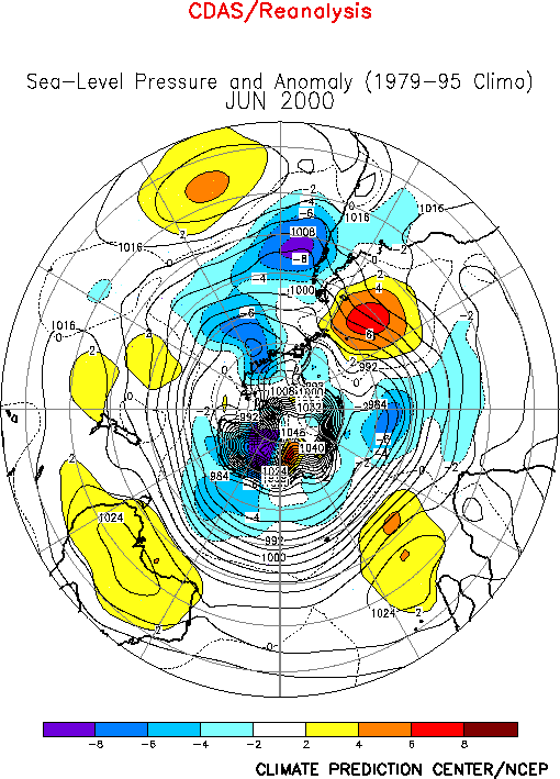
The Southern Hemisphere circulation during June (Fig. E15)
featured above-average heights over the middle latitudes of both the central South Pacific
and western South Atlantic, and in the region southeast of Africa, and below-normal
heights over the high latitudes of the eastern South Pacific and over the region south of
Australia. Much of the central latitudes have experienced above-average heights for more
than a year, in association with an extremely persistent pattern of anticyclonic
circulation anomalies in both hemispheres extending from the Atlantic ocean eastward to
Australasia (See Northern Hemisphere Highlights above).
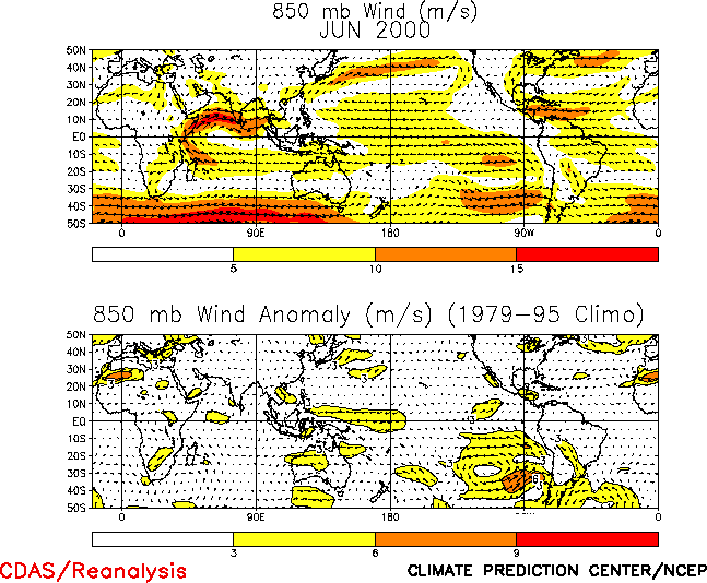
In Australia, below-average temperatures were observed across the northern part of the
continent during June (Fig. E1), in association with an
anomalous anticyclonic circulation and anomalous easterly winds in that region (Figs. E14, T20 bottom). This anomalous
anticyclonic circulation also contributed to a continuation of below-average rainfall over
both southwestern and southeastern Australia during the month (Fig.
E3).


