The
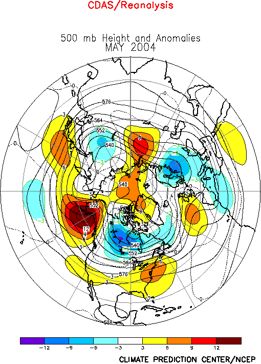
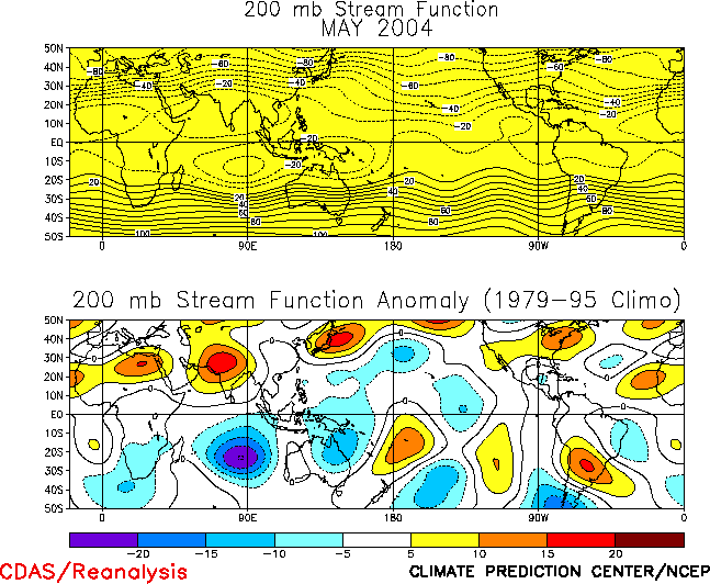
500-hPa circulation during May featured above average heights across the
North Pacific from Japan to Alaska, over the southern United States, the
eastern North Atlantic, and central Russia, and below-average heights over
the central subtropical North Pacific, Canada, Europe, and northern China (Fig.
E9). The circulation anomalies over the North Pacific and North
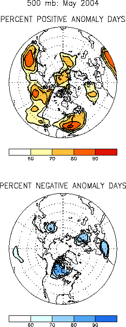
America were especially persistent during the month (Fig.
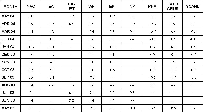
E11), and contributed to a near-record negative value (-3.5) of the
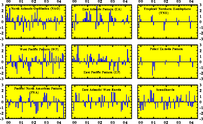
Pacific/ North American (PNA) teleconnection index (Table
E1, Fig. E7).
Prominent
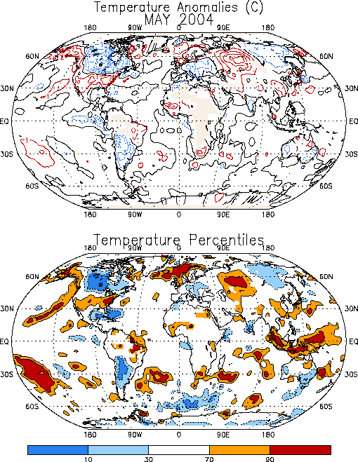
temperature departures during May included warmer than average conditions
across the southern U.S. and central Russia, and well below-average
temperatures across Canada (Fig. E1). The
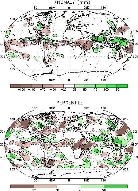
prominent precipitation anomalies during May includeded above-average
rainfall across the Midwest and Great Lakes regions of the United States,
and below-average totals over the extreme southeastern U.S. and western
North Atlantic (Figs. E3, E5).
a. Pacific/North America
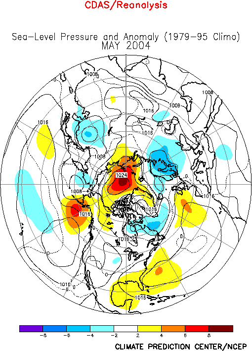
The
circulation over the Pacific/North American sector reflected a near-record
amplitude (-3.5) for the negative phase of the PNA teleconnection pattern (Table
E1, Fig. E7). Key aspects of this pattern
included above-average 500-hPa heights over the Gulf of Alaska and southern
U.S., and below-average heights over the central subtropical North Pacific
and Canada (Fig. E9). Associated with this
anomaly pattern the mean upper-level ridge and trough axes were located
over Alaska and western Canada, approximately 30°
west of their climatological positions over the Rocky Mountains and eastern
Canada, respectively.
In
the middle latitudes the negative PNA pattern was associated with a
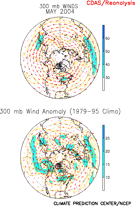
pronounced weakening and westward retraction of the East Asian jet in the
vicinity of the date line, and with increased diffluence throughout the jet
exit region (Figs. T21, T22).
It was also associated with an anomalous jet core across the northern U.S.
and southeastern Canada (Fig. E10).
Over
North America this anomalous jet stream is consistent with an enhanced
north-south surface temperature gradient, as indicated by near-record cold
surface temperatures (2°-5°
below average) across most of Canada and anomalously warm temperatures (1.0°-1.5°C
above average) across the southern and central U.S. (Fig.
E1). In Canada surface temperatures were generally in the lowest 10th
percentile of occurrences. These unusually cold temperatures are related to
the northwesterly flow of arctic air from Alaska and the Beaufort Sea into
western Canada in the area downstream of the mean upper-level ridge axis (Figs.
E8, E10).
The
anomalous circulation across North America also contributed to
above-average rainfall across the northern United States. The largest
surpluses were observed in the Midwest and Great Lakes regions where
area-averaged totals reached the 90th percentile of occurrences
(Fig. E3). These regions were situated
downstream of the mean upper-level trough axis within the region of
enhanced surface temperature contrast.
b. North Atlantic
North Atlantic SSTs have been considerably
above average during the past year. During May they remained above the 90th
percentile across the high latitudes of the North Atlantic (Fig.
E1), which contributed to ongoing warmth across Iceland and parts
of Great Britian. This anomalous warmth is likely associated with the
ongoing warm phase of the Atlantic multi-decadal mode that began in
approximately 1995.
2. Southern Hemisphere
In
the Southern Hemisphere the 500-hPa circulation during May featured
above-average heights over the central South Pacific, southern South
America, and southern Africa, and below-average heights over southern
Australia, at high latitudes over the eastern South Pacific and the central
South Atlantic, and over the central Indian Ocean (Fig.
E15).
Over
Australia the circulation reflected a strengthening and equatorward shift
of the jet stream (Fig. T21). Southeastern
Australia experienced upper-level convergence (Fig.
T23) and descending motion within the right entrance region of the
jet, which resulted in below-average precipitation during the month (Fig.
E3). An anomalous inland penetration of cold air at 850-hPa from
the Great Australian Bight was also evident (Fig.
T20), which resulted in anomalously cool surface temperatures
across southeastern Australia (Fig. E1).
Much
of central extratropical South America experienced significantly
below-average surface temperatures during May, with temperatures in many
regions east of the Andes Mountains falling within the lowest 10th
percentile of occurrences. These cool temperatures appear to be related to
the significant weakening of the westerly winds and associated downslope
flow equatorward of the strong upper-level ridge (Figs. T20,
T21, E15).
The below-normal temperatures in this region and over parts of
Australia contributed to the lowest value of the Southern Hemisphere
land-only temperature time series since 1992 (Fig.
E2, bottom).


