Forecast Forum - April 1999
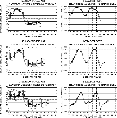
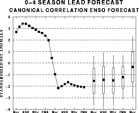
The canonical correlation analysis (CCA) forecast of SST in the central Pacific
(Barnett et al. 1988, Science, 241, 192-196; Barnston and Ropelewski 1992, J.
Climate, 5, 1316-1345), is shown in Figs. F1 and F2. This forecast is
produced routinely by the Prediction Branch of the Climate Prediction Center. The
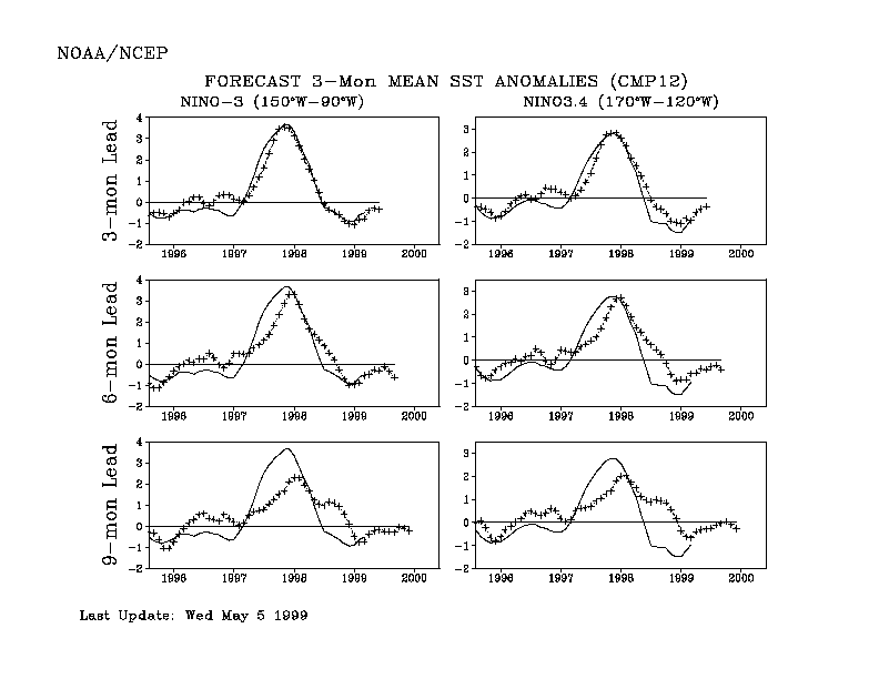
predictions from the National Centers for Environmental Prediction (NCEP) coupled
ocean/atmosphere model (Ji et al. 1998, Mon. Wea. Rev, 126, 1022-1034) are
presented in Figs. F3 and F4. Predictions from the Cane and Zebiak model (Cane et
al. 1986, Nature, 321, 827-832; Zebiak and Cane 1987, Mon. Wea. Rev.,
115, 2262-2278) are shown in Figs. F5 and F6. Predictions from the modified
Cane and Zebiak model (Chen et al. 1998, Geophys. Res. Let., 103,
2387-2840), referred to in the figures as LDEO3, are shown in Figs. F7 and F8.
Predictions using linear inverse modeling (Penland and Magorian 1993, J. Climate, 6,
1067-1076) are shown in Figs. F9 and F10. Predictions from the Scripps / Max Planck
Institute (MPI) hybrid coupled model (Barnett et al. 1993, J. Climate, 6,
1545-1566) are shown in Fig. F11.
The CPC and the contributors to the Forecast Forum caution potential users of
this predictive information that they can expect only modest skill.
Discussion and Outlook
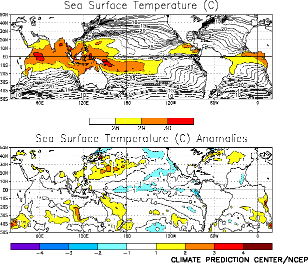
Cold episode conditions continued in the tropical Pacific during April, as sea surface
temperatures (SSTs) remained well below normal across the central and east-central
equatorial Pacific (Fig. T18 and Table T2).
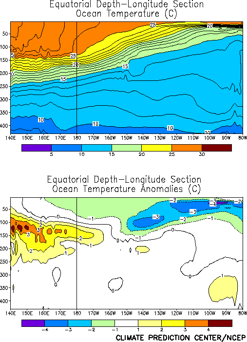
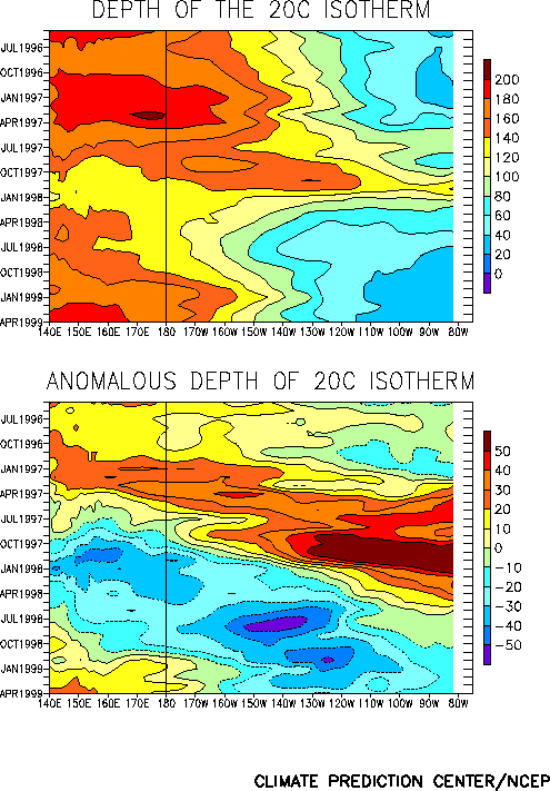
Negative subsurface temperature anomalies (Fig. T17) and a
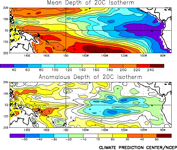
shallower than normal oceanic thermocline (Fig. T16)
continue to dominate the equatorial Pacific, though the magnitude of the anomalies has
decreased in recent months (Fig. T15). Accompanying these
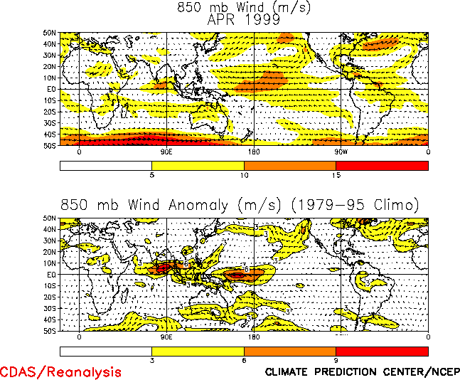
conditions, the mean low-level equatorial easterly winds remained much stronger than
normal over the west-central and central tropical Pacific and near normal over the eastern
Pacific (Fig. T20 ). Enhanced low-level westerlies were
also observed over the eastern Indian Ocean and Indonesia. This pattern of low-level winds
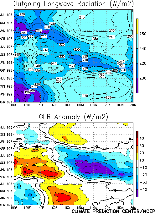
contributed to enhanced low-level convergence and precipitation, as inferred from the
anomalous Outgoing Longwave Radiation (OLR), over the eastern Indian Ocean, Indonesia, and
the Philippines and suppressed precipitation over the equatorial central Pacific (Fig. T25). This pattern has been very persistent since the NH
1998 autumn (Fig. T8 ), and is consistent with cold
episode conditions.
The latest NCEP coupled model forecast (Figs. F3
and F4) indicates that cold episode conditions will
persist in the tropical Pacific through the NH 1999 summer. The NCEP statistical model
forecast (Figs. F1 and F2 ) is
generally consistent with the NCEP coupled model, but it suggests that cold episode
conditions will be somewhat stronger during this period. Other statistical and coupled
model forecasts are generally consistent with the NCEP models.
Weekly updates of SST, 850-hPa wind and OLR are available on the Climate Prediction
Center homepage at: http://www.cpc.ncep.noaa.gov (La Niña / Weekly Update).
|


