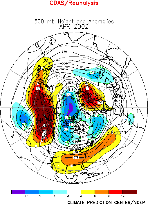
The Northern Hemisphere circulation
during April featured a persistent pattern of above-average 500-hPa heights over the high
latitudes of the North Pacific, the southeastern United States, the central North
Atlantic, and Scandinavia, and persistent below-average heights over the central North
Pacific, western Canada, the polar region, and the high latitudes of the North Atlantic (Figs.
E10, E12). These conditions
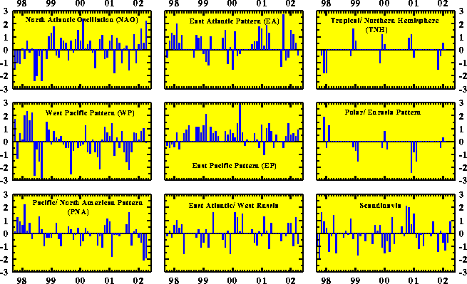
reflected a strong positive phase (+2.2) of the North Atlantic Oscillation (NAO), and a
continuation of the strong negative phase (-1.9) of the Pacific/ North American (PNA)
teleconnection pattern observed in March (Table E1, Figs. E7, E8). In both sectors these anomalies
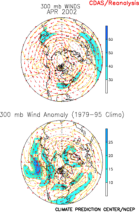
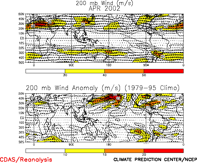
were accompanied by pronounced departures from normal in the positions of the mean jet
streams (Figs. E11, T21), and in
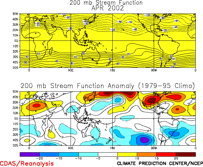
the positions of the mean upper-level ridges and troughs (Figs. E10,
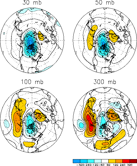
T22).Over Canada and the polar region the negative height
anomalies were observed to strengthen upward to at least 30-hPa (Fig.
S1), suggesting a connection to anomalous conditions in both the lower and middle
stratosphere. In contrast, the positive height anomalies over the high latitudes of the
North Pacific and North Atlantic weakened considerably above the level of the tropopause
level, suggesting a dynamical link to the associated elevated tropopause but not to
stratospheric conditions higher up.
a. North Pacific and North America
The strong negative phase of the PNA teleconnection pattern during April was
accompanied by 200-hPa easterly wind anomalies averaging 15-25 m s-1 throughout
the climatological exit region of the East Asian jet stream (Fig. T21,
E11, right), in association with a complete disappearance of
that jet east of Japan (Fig. T21, top). A westward
retraction of the East Asian jet is often accompanied by a corresponding westward shift of
the mean upper-level ridge axis from western North America to the high latitudes of the
central North Pacific, which was also observed in April (Figs. E10,
T22, top).
The location of the downstream upper-level trough axis normally located over eastern
North America was also shifted westward to western North America during the month (Fig. E10). This shift contributed to anomalous northwesterly
flow across western Canada (Fig. E11), which led to
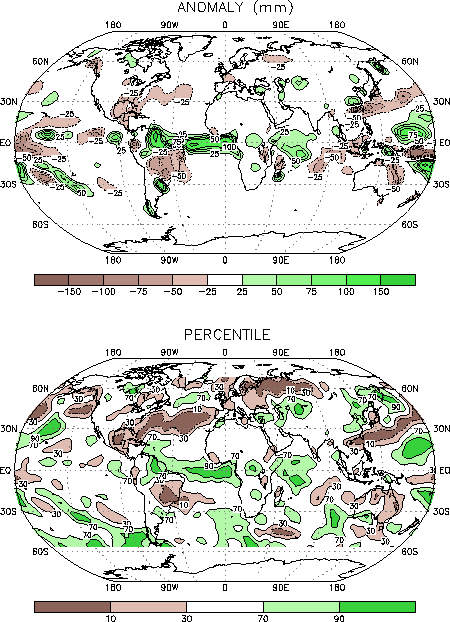
significantly below-average surface temperatures (below the 10th percentile)
throughout the region (Fig. E1). Similar circulation
patterns during March also contributed to below-average temperatures over much of Canada.
Over the northern United States the above circulation was accompanied by an anomalous
jet core, which separated below average temperatures in southern Canada from well above
average temperatures across the southern half of the U.S.. An associated amplified
subtropical ridge over the Gulf Coast States (Fig. T22, top)
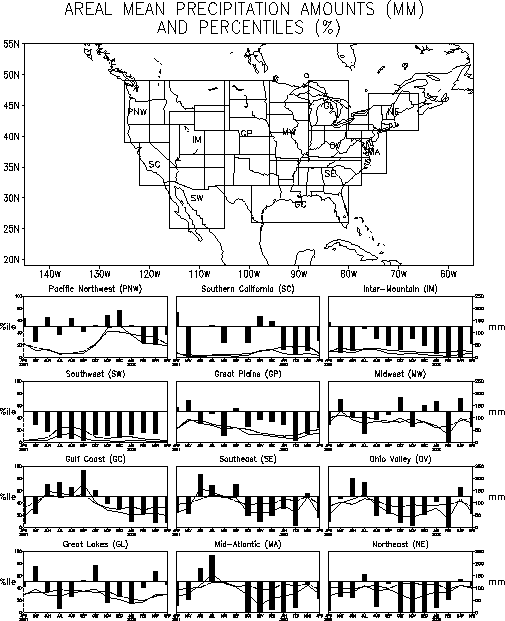
contributed to below-average precipitation totals across the Gulf Coast and Southeast
during the month (Figs. E5, E6).
Farther north above average precipitation totals were observed along the equatorward flank
of the anomalous jet stream from eastern Missouri to western Virginia (Fig. E6, top right).
b. North Atlantic and Europe
The strong positive phase of the NAO (+2.2; Table E1)
during April was associated with above-average heights extending from the central United
States eastward to southern Europe, and with below-average heights over the high latitudes
of the North Atlantic (Fig. E10). This anomaly pattern was
accompanied by a nearly continuous jet stream that extended from the north-central United
States eastward to just west of Great Britain (Fig. E11, left).
In combination with a strong upper-level ridge over Scandinavia, this circulation
contributed to above-average surface temperatures over the eastern North Atlantic, western
Europe and Scandinavia, with temperature anomalies in some regions exceeding the 90th
percentile (Fig. E1, bottom). It also contributed to
significantly below-average precipitation (below the 10th percentile) over
northeastern Europe and northwestern Russia (Fig. E3).
Farther downstream near average surface temperatures covered much of Eurasia during
April. This represents a marked departure from the record or near-record high surface
temperatures over most of Asia during February and March.
2. Southern Hemisphere
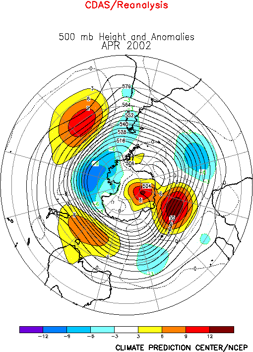
The Southern Hemisphere 500-hPa circulation during April featured an anomalous zonal
wave-3 pattern, characterized by above-average heights over the central South Pacific, and
in the areas south of both Australia and Africa, and below-average heights over the high
latitudes of the South Pacific, southern South America, and both the central Atlantic and
Indian Oceans (Fig. E16). Over the South Pacific this
anomaly pattern is similar to that which had previously persisted from October 2001-
February 2002.
Over northern and eastern Australia below-average rainfall was observed during April
for the fifth consecutive month (Fig. E4). During April the
below-average rainfall was partly associated with an anomalous anticyclonic circulation at
200-hPa over the eastern half of the country (Fig. T21, bottom).
Significantly above-average surface temperatures covered much of the continent during the
month, with departures exceeding the 90th percentile extending from Indonesia
southward to southeastern Australia (Fig. E1). This warmth
was associated with a much larger area of above-average SSTs that spanned the eastern
Indian Ocean and most of the western equatorial Pacific (Fig. E1).
Over southern Africa slightly above-average rainfall totals during April (Fig. E4) marked the end to that region’s 2001-2002
monsoon season. Rainfall departures were mixed during the season, with above-average
totals during November-December and April, and below-average totals during January-March.
Area-averaged rainfall totals were highest during November-December, which contrast to the
climatological January-February peak in monsoon rains.
Over central South America an amplified subtropical ridge at 200-hPa (Fig. T22) contributed to exceptionally warm and dry
conditions over southeastern Brazil during April, with temperatures exceeding the 90th
percentile and rainfall totals dropping below the 10th percentile. In contrast,
the very strong upper-level trough over the high latitudes of the eastern South Pacific
contributed to cooler and wetter than normal conditions over extreme southern South
America and surrounding ocean regions.


