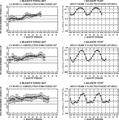
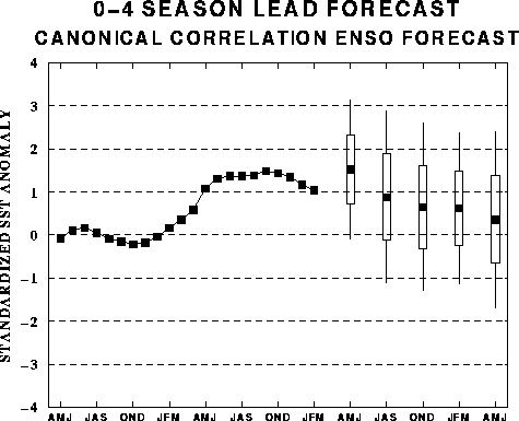
The canonical correlation analysis
(CCA) forecast of SST in the central Pacific (Barnett et al. 1988, Science, 241,
192-196; Barnston and Ropelewski 1992, J. Climate, 5, 1316-1345), is shown
in Figs. F1 and F2. This forecast
is produced routinely by the Prediction Branch of the Climate Prediction Center. The
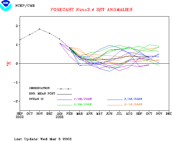
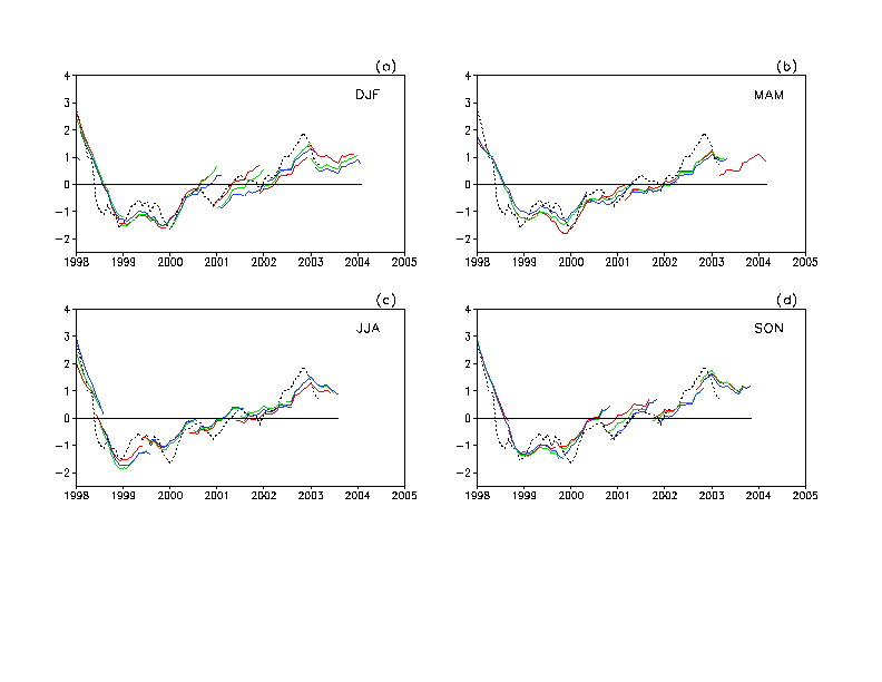
predictions from the National Centers for Environmental Prediction (NCEP) coupled
ocean/atmosphere model (Ji et al. 1998, Mon. Wea. Rev, 126, 1022-1034) are
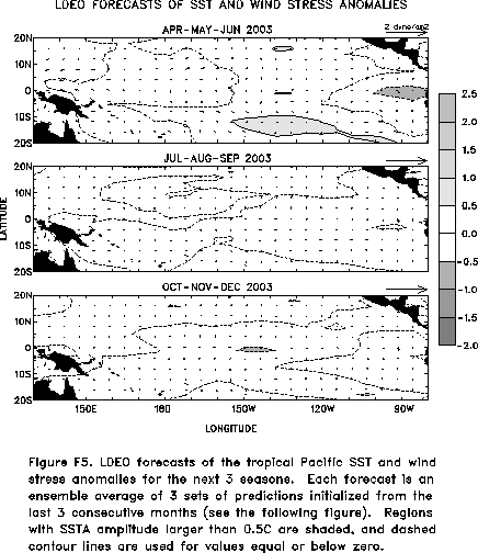
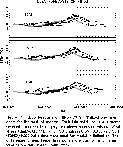
presented in Figs. F3 and F4a, F4b. Predictions from the Markov model (Xue, Y., A. Leetmaa,
and M. Ji, 2000: ENSO prediction with Markov model: The impact of sea level. J. Climate,
13, 849-871) are shown in Figs. F5 and F6.
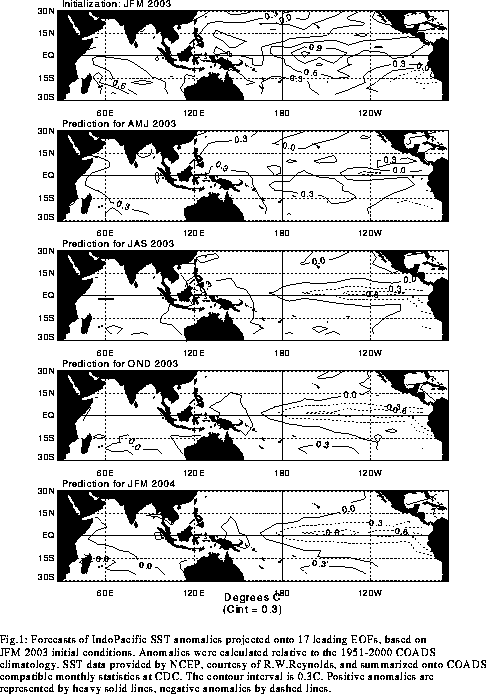
Predictions from the latest version of the LDEO model (Chen, D., M. A. Cane, S.
E. Zebiak, Rafael Canizares and A. Kaplan, 2000, Geophys. Res. Let., 27,
2585-2587) are shown in Figs. F7 and F8.
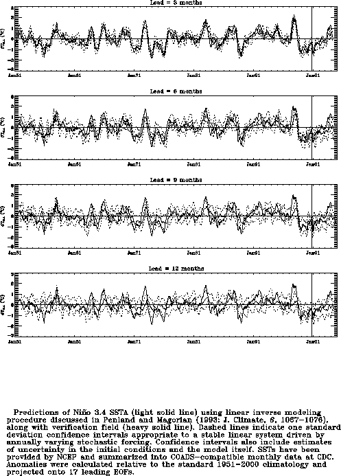
Predictions using linear inverse modeling (Penland and Magorian 1993, J. Climate, 6,
1067-1076) are shown in Figs. F9 and F10.
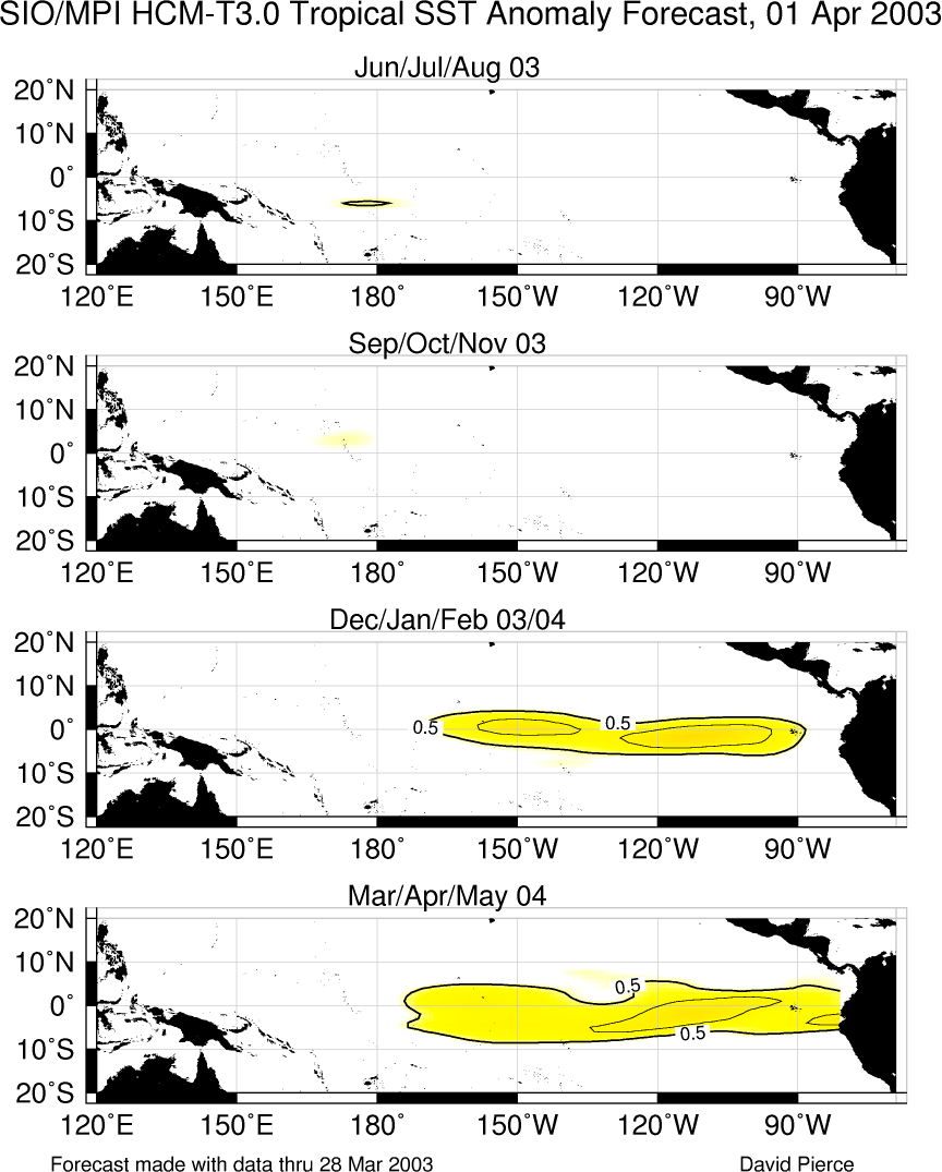
Predictions from the Scripps / Max Planck Institute (MPI) hybrid coupled model (Barnett et
al. 1993, J. Climate, 6, 1545-1566) are shown in Fig. F11. Predictions from the ENSO-CLIPER statistical model
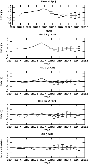
(Knaff, J. A. and C. W. Landsea 1997, Wea. Forecasting, 12, 633-652) are
shown in Fig. F12.
The CPC and the contributors to the Forecast Forum caution potential users of
this predictive information that they can expect only modest skill.
Outlook
Based on the recent evolution of conditions in the
tropical Pacific and on the latest coupled model and statistical model
forecasts, near-normal conditions are expected to prevail in the
tropical Pacific through September 2003.
Discussion
Warm episode (El NiZo)
conditions continued to weaken during March 2003. Sea-surface
temperature anomalies continued to decrease throughout the central and
eastern equatorial Pacific during the month (Figs. T5
and T9), while low-level equatorial
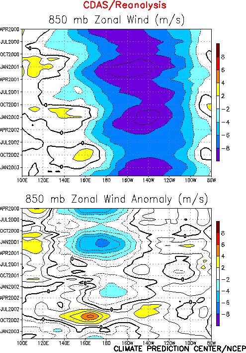
easterlies continued to strengthen (Figs. T7
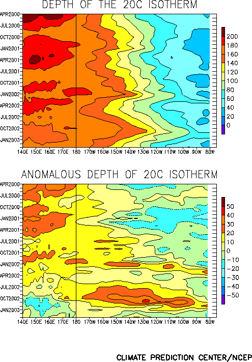
and T20). Since December 2002 there has
also been a steady decrease in the magnitude and extent of the positive
subsurface temperature anomalies, indicating a depletion of the excess
warmth in the upper ocean of the equatorial Pacific (Figs. T15
and T17). This evolution is typical during
the decay phase of warm episodes.
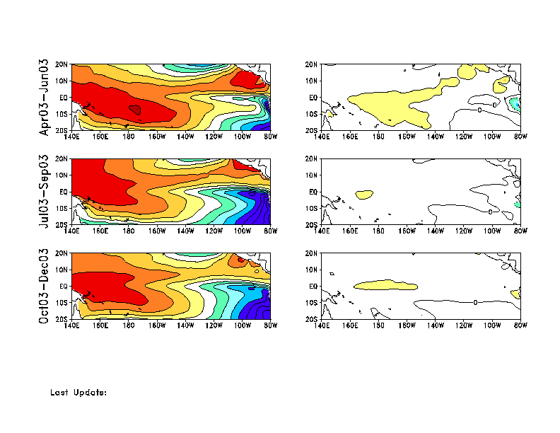
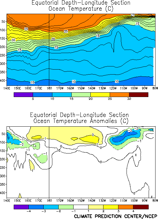
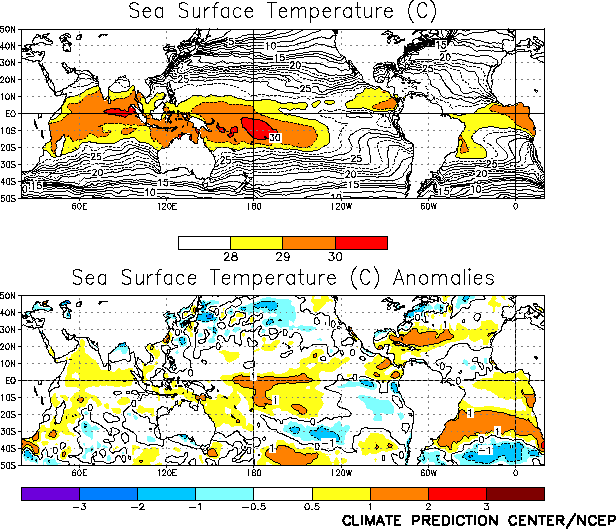
In spite of these trends, significant positive SST anomalies remained
in the central equatorial Pacific during March 2003 , with anomalies
greater than +1EC extending from 170EE
to 140EW (Fig. T18).
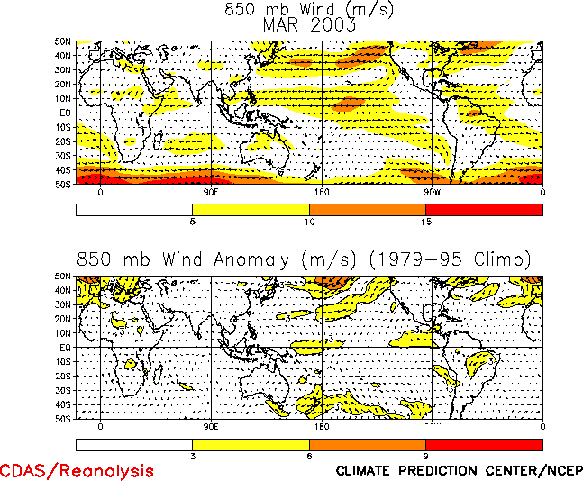
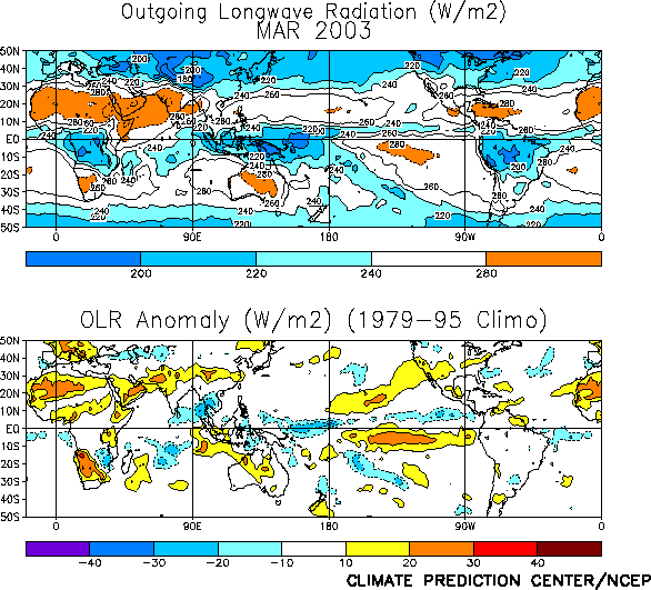
In addition, enhanced precipitation and cloudiness occurred over western
portions of this region (Fig. T25). The
Tahiti-Darwin SOI remained negative (!1.0)
for the 13th consecutive month (Table T1),
while the equatorial SOI was closer to zero.
Consistent with current conditions and recent observed trends, a
majority of the coupled model and statistical model forecasts indicate
that near-normal conditions will prevail through September 2003 (Figs. F1,
F2, F3, F4,
F5, F6, F7,
F8, F9, F10,
F11, F12).
However, there is uncertainty in this forecast, as some forecasts
indicate the possibility of continued weak El NiZo
conditions (e.g. the NCEP CCA, Figs. F1, F2)
while others indicate the development of La NiZa
conditions during the second half of 2003 (e.g. the Linear Inverse
Model, Figs. F9, F10).
All such models have relatively low skill during the transition phases
of the ENSO cycle.
Weekly updates of SST, 850-hPa wind, OLR, and the equatorial subsurface temperature
structure are available on the Climate Prediction Center homepage at:
http://www.cpc.ncep.noaa.gov (Weekly Update).


