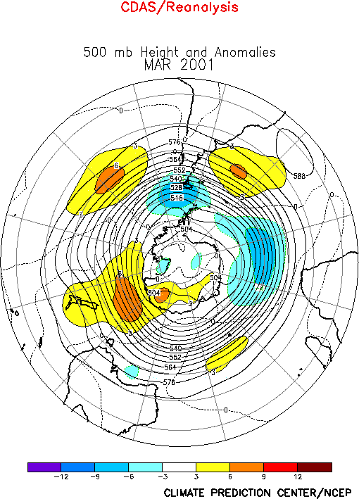
| The extratropical circulation during
March featured above-normal heights over the eastern North Pacific, the polar region, and
along an axis extending eastward from northern Africa to south-central Russia (Figs. E10, E12). The circulation also
featured a large area of below-average heights extending northeastward from the eastern
United States to northwestern Russia, along with a pronounced cyclonic circulation anomaly
over the central subtropical North Pacific (Fig. T22, bottom).
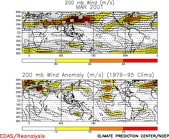
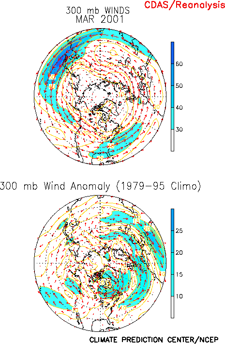
Over the North Pacific, these anomalies were accompanied by a pronounced westward
retraction of the East Asian jet to well west of the date line (Fig.
T21, top) and a highly amplified split-flow pattern over the eastern half of the
North Pacific. These conditions are strongly linked to the ongoing La Niña episode. Over
eastern North America and the North Atlantic the circulation anomalies during March were
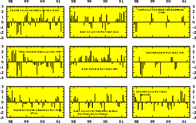
associated with a strong negative phase of the North Atlantic Oscillation (NAO) (Table E1, Figs. E7, E8). The
subtropical circulation again reflected considerable symmetry of the upper-level
circulation anomalies in both hemispheres (Fig. T22, bottom).
Notable aspects of this anomaly pattern included amplified troughs (cyclonic circulation
anomalies) over the mid-Pacific of both hemispheres, and anticyclonic circulation
anomalies extending eastward in the Northern Hemisphere from the Atlantic Ocean to Asia
and in the Southern Hemisphere from the Atlantic Ocean eastward to Australia. This overall
pattern has prevailed during much of the 1998-2001 Pacific cold episode, and is a leading
mode of atmospheric variability on both the interannual and interdecadel time scales.
a. North America
The circulation over North America reflected above-average heights over the western
United States and large portions of Canada, and below-average heights over the eastern
half of the United States (Fig. E10). In the west these
conditions were accompanied by an enhanced westerly flow of mild air into western Canada,
while in the east they were associated with the negative phase of the NAO. Over the
eastern U.S. these circulation anomalies were accompanied by an amplification of the mean
trough, and amplified confluence within the entrance region of the North Atlantic jet
stream (Fig. E10).
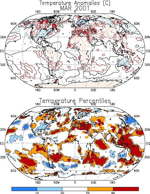
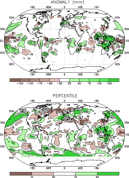
The pattern of temperature anomalies over North America closely matched the upper-level
circulation anomalies, as indicated by above-average temperatures across the western U.S.
and Canada and below-average temperatures across the eastern U.S. (Fig.
E1). In Canada, temperatures in many areas averaged 2°-3°C above normal during
the month, while in the U.S. temperatures generally averaged 2°C below average across the
southeast and lower Midwest.
The prominent precipitation anomalies during the month included below-average rainfall
in the Midwest and above-average rainfall along the Gulf Coast and portions of the eastern
seaboard (Fig. E3). In the Gulf coast region these
above-average rains were associated with the strong negative phase of the NAO.
Nonetheless, substantial rainfall deficits remain
throughout the region, in association with the ongoing La Niña episode.
b. North Atlantic/Europe
The North Atlantic Oscillation is the most prominent, recurring circulation pattern to
impact temperature and precipitation across Europe. During March the strong negative phase
of the NAO was accompanied by a substantial strengthening of the North Atlantic jet stream
(Fig. E11), as well as a southward shift of the mean jet
core to northern Spain. This flow pattern resulted in increased marine flow into Europe,
along with increased storminess and enhanced rainfall across central Europe. Above-average
temperatures also prevailed across Europe and the eastern Mediterranean during the month (Fig. E1), with the most significant anomalies exceeding the 90th
percentile from southern Italy eastward to the Middle East.
c. Stratosphere
Strong winter stratospheric warming over the Northern Hemisphere polar region reached
peak levels at the end of January and early February (Fig. S4).
In March, cold air once again became reestablished over the polar region in the middle and
upper stratosphere (see 10 and 2 hPa in Fig. S4). However,
in the lower stratosphere, positive anomalies (Fig. S3)
and positive height anomalies (Fig. S1) remained dominant over the north polar region. Associated with the
lower stratosphere positive height and temperature anomalies, there were also strong
positive total ozone anomalies which prevailed over the north polar region (Fig. S6). Over middle latitudes of the Northern hemisphere,
negative anomalies of up to 10 percent in total ozone predominated. However there were no
extremely low values of total ozone over the north polar region during March 2001, such as
were evident in winter and early spring of 1999-2000. The very low values in the region of
depleted ozone during the winter of 2000-2001 disappeared by mid February, in association
with the stratospheric warming in January and February and its related temperature and
circulation changes.
2. Southern Hemisphere
In the Southern Hemisphere extratropics, the circulation during March featured a
continuation of above-normal heights over large portions of the middle latitudes (Fig. E16). Over the central and eastern South Pacific, the
above-normal heights were located immediately poleward of the La Niña-related subtropical
cyclonic circulation anomalies, which is similar to the anomaly pattern observed in the
Northern Hemisphere (Fig. T22, bottom).
Well above-average temperatures (Fig. E1) and enhanced
rainfall (Fig. E3) were observed over much of northern
Argentina, Uruguay, and extreme southern Brazil during March. Anomalously warm
temperatures were also observed over southeastern Africa and portions of southern
Australia, while considerably below-average temperatures prevailed over most of
northwestern Australia. |


