|
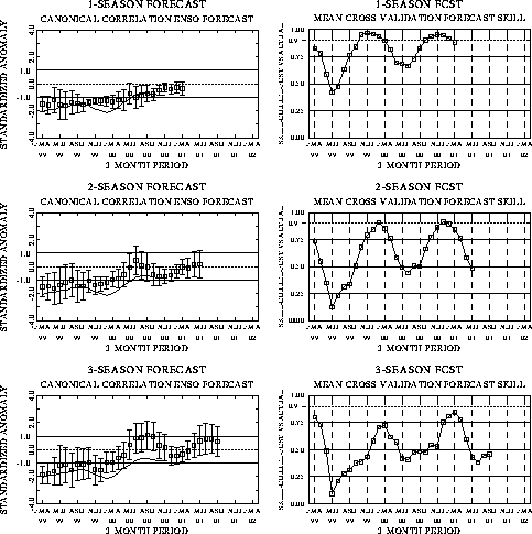
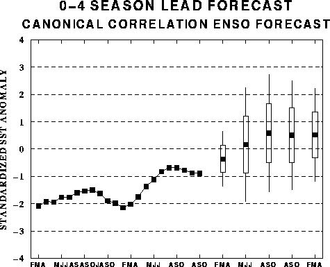
The canonical correlation analysis (CCA) forecast
of SST in the central Pacific (Barnett et al. 1988, Science, 241, 192-196;
Barnston and Ropelewski 1992, J. Climate, 5, 1316-1345), is shown in Figs.
F1 and F2. This forecast is produced
routinely by the Prediction Branch of the Climate Prediction Center. The predictions from
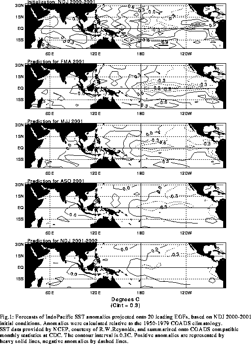
the National Centers for Environmental Prediction (NCEP) coupled ocean/atmosphere model
(Ji et al. 1998, Mon. Wea. Rev, 126, 1022-1034) are presented in Figs. F3 and F4. Predictions from the latest
version of the LDEO model (Chen, D., M. A. Cane, S. E. Zebiak, Rafael Canizares and A.
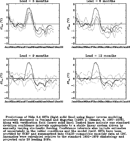
Kaplan, 2000, Geophys. Res. Let., accepted) are shown in Figs. F5 and F6. Predictions using linear
inverse modeling (Penland and Magorian 1993, J. Climate, 6, 1067-1076) are
shown in Figs. F7 and F8.
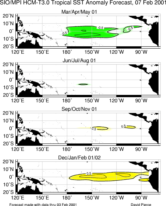
Predictions from the Scripps / Max Planck Institute (MPI) hybrid coupled model (Barnett et
al. 1993, J. Climate, 6, 1545-1566) are shown in Fig. F9.
The CPC and the contributors to the Forecast Forum caution potential users of
this predictive information that they can expect only modest skill.
Outlook
Cold episode (La Niña) conditions are expected to continue through the remainder of
the NH winter and into the spring of 2001, followed by near-normal conditions during the
summer of 2001.
Discussion
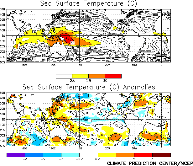
Cold episode conditions continued in the tropical Pacific during January, as sea
surface temperatures (SSTs) remained well below normal across the central and east-central
equatorial Pacific (Fig. T18 and Table T2).
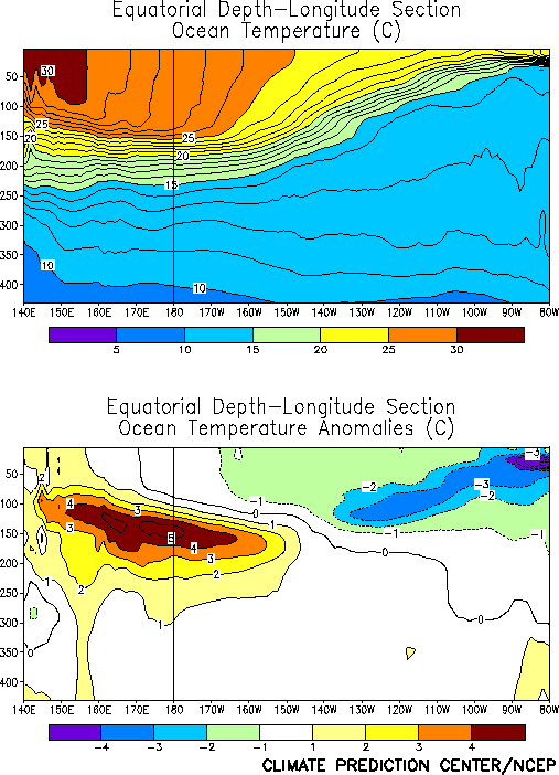
Negative subsurface temperature anomalies and a shallower than normal oceanic thermocline
continue to dominate the eastern equatorial Pacific, while positive subsurface temperature
anomalies and a deeper than normal thermocline continued in the western equatorial Pacific
(Figs. T16 and T17). The
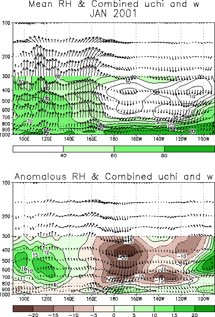
cooler-than-normal surface waters contributed to a vigorous Walker circulation over the
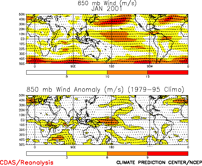
equatorial central Pacific (Fig. T29) characterized by
enhanced low-level easterlies (Fig. T20), enhanced
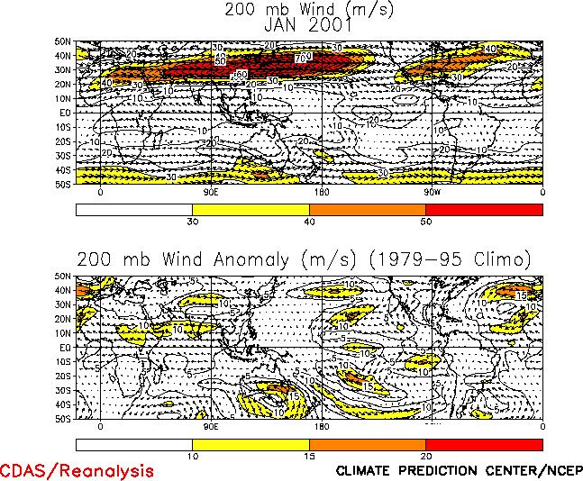
upper-level westerlies (Fig. T21), suppressed deep
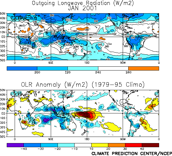
convection over the western and central equatorial Pacific, and enhanced deep convection
over the Phillippines and Indonesia (Figs. T25 and E3). The pattern of tropical convection was not strongly
influenced by tropical intraseasonal (Madden-Julian Oscillation) activity, which weakened
during January as cold-episode circulation features strengthened. This is in contrast to
the second half of 2000 which featured strong, relatively regular MJO activity (Fig. T12).
Over the past two years there has been a gradual expansion of the area of positive
equatorial subsurface temperature anomalies into the central Pacific (Fig.
T15). This evolution is consistent with a slow decay of the subsurface thermal
structure that characterizes the mature phase of cold episodes. Thus, it is likely that
cold episode conditions will gradually weaken over the next several months, with
near-normal conditions during the summer of 2001. This assessment is generally supported
by the most recent NCEP statistical and coupled model forecasts (Figs. F1, F2, F3, F4), as well as by other available coupled model and
statistical model predictions (Figs. F5, F6,
F7, F8, F9),
which indicate a gradual weakening of cold episode conditions during the next few months.
Thereafter, the models indicate near-normal or slightly warmer-than-normal conditions
during the second half of 2001.
Based on current conditions in the tropical Pacific, on the NCEP SST predictions, and
on results from historical studies on the effects of cold episodes, we expect
wetter-than-normal conditions to prevail over Indonesia, northern Australia, and southern
Africa during the remainder of the NH winter. Over the United States warmer-than-normal
conditions are expected along the southern tier of states from southern California
eastward to Florida, while cooler-than-average conditions are likely over western and
central Canada and in the upper Midwest and Great Lakes.
Weekly updates of SST, 850-hPa wind and OLR are available on the Climate Prediction
Center homepage at: http://www.cpc.ncep.noaa.gov (Weekly
Update).
|


