HOME> Expert Assessments>Hazards Outlook
For 3-7 day hazards see Weather Prediction Center's: WPC 3-7 Day Hazards
U.S. Week-2 Hazards Outlook - Made June 30, 2025 | About the Hazards Outlook
ATTENTION:
We would like to hear from you! Please provide your feedback and suggestions about these outlooks by taking the customer satisfaction survey HERE.
| Composite Map Day 8-14 |
Experimental Probabilistic Outlooks |
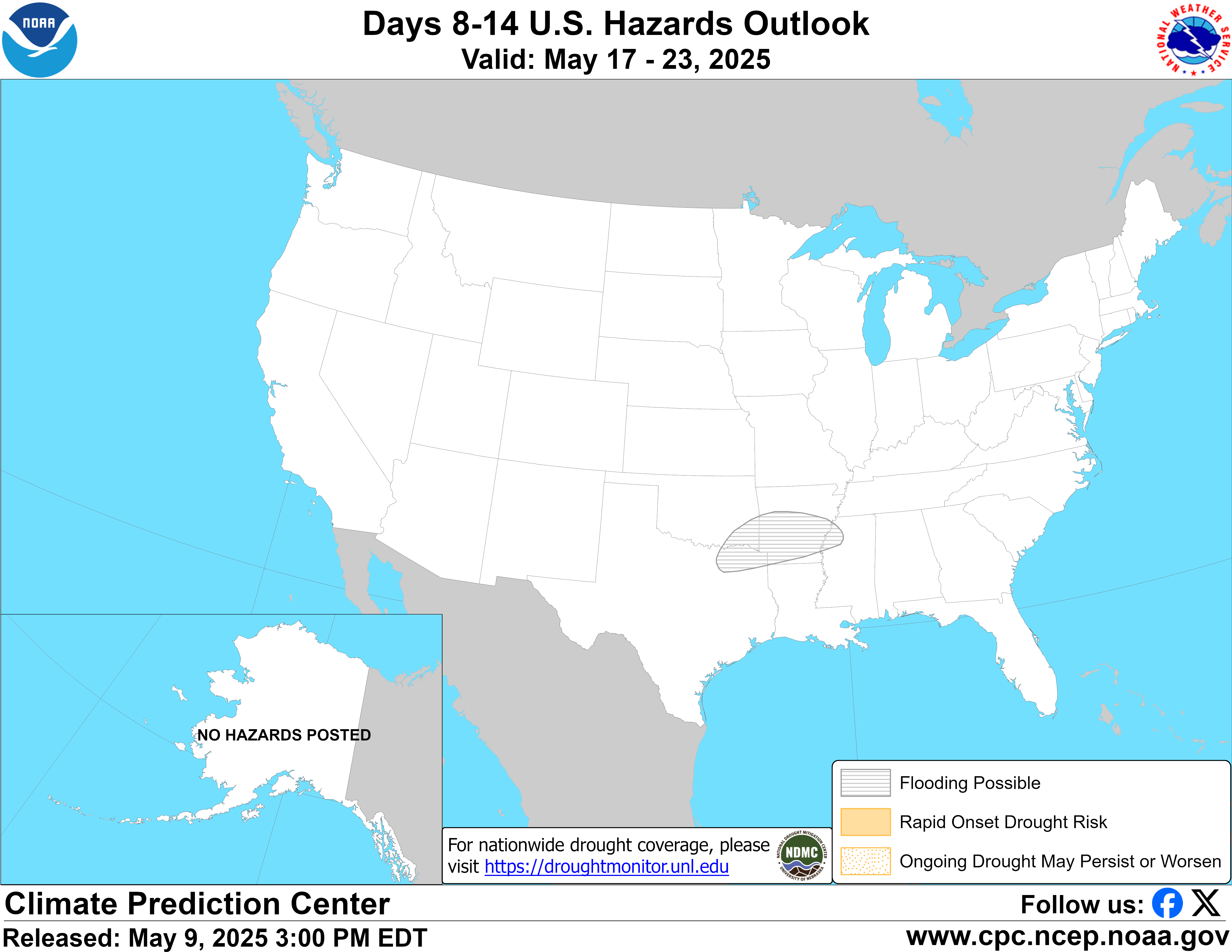 |
Valid Tuesday July 08, 2025 to Monday July 14, 2025
US Hazards OutlookNWS Climate Prediction Center College Park MD
300 PM EDT June 30 2025
Synopsis: Mid-level high pressure is forecast to strengthen and slowly retrograde into the western contiguous U.S. (CONUS) during week-2. This supports an increased risk of extreme heat across portions of the Northwest, extending southward through the California Central Valley. Extreme heat also remains a concern across the Southern Plains and Lower Mississippi Valley due to elevated humidity levels combined with above-normal temperatures. Monsoon activity remains forecast across the Southwest, further enhanced by continued tropical cyclone activity across the East Pacific. A slow moving frontal system favors increased chances of heavy precipitation across portions of the southeastern U.S. and Mid-Atlantic.
Hazards
- Slight risk of extreme heat across portions of the Southern Plains and Lower Mississippi Valley, Tue-Mon, Jul 8-14.
- Slight risk of extreme heat across portions of Interior California, the Pacific Northwest, Great Basin, and Northern Rockies, Tue-Mon, Jul 8-14.
- Slight risk of heavy precipitation across portions of the Southwest, Central and Southern Rockies, and Central Great Basin, Tue-Mon, Jul 8-14.
- Slight risk of heavy precipitation across portions of the Lower Mississippi and Tennessee Valleys, Southern Appalachians, Mid-Atlantic, and Southeast, Tue-Sat, Jul 8-12.
- Flooding possible across portions of Arizona and New Mexico.
For Thursday July 03 - Monday July 07: WPC Days 3-7 U.S. Hazards
For Tuesday July 08 - Monday July 14: Mid-level ridging is predicted to amplify while slowly retrograding into the western CONUS during week-2. The 0z ECENS continues to depict a 597-dm ridge axis across the Four Corners early in the period, with +60 meter positive height anomalies extending over much of the Northwest. The 0z GEFS and CMCE are slightly less amplified compared to the ECENS but depict the same general evolution. At the surface, this translates to increasing chances for above-normal temperatures over much of the West. The initial focus for elevated extreme heat potential is favored across the Northwest, and then expanding southward through the California Central Valley by the middle of the period based on the progression of 20 percent or greater probabilities for temperatures exceeding the 85th climatological percentile in the GEFS and ECENS Probabilistic Extremes Tools (PETs). A slight risk of extreme heat is posted across portions of Interior California, the Pacific Northwest, Great Basin, and Northern Rockies for all of week-2. Predicted temperatures based on the uncalibrated ECENS and GEFS range from the mid-90s deg F across the northern Great Basin to possibly above 105 deg F across the California Central Valley. While even hotter temperatures are possible across the Desert Southwest, this region is excluded from the slight risk due higher extreme heat thresholds and additional uncertainty regarding the monsoon potentially leading to relatively cooler temperatures.
Above-normal temperatures also remain forecast across portions of the Southern Plains and Lower Mississippi Valley with forecast highs generally in the upper 90s to possibly the low 100s deg F across central Texas. Elevated humidity is likely to boost heat index values by several degrees further increasing the risk for extreme heat. The calibrated skill weighted heat tool depicts probabilities of 20-40 percent for heat index values exceeding the 95th climatological percentile across the region, with some areas potentially having heat index values above 110 deg F. As a result of these enhanced signals, the slight risk for extreme heat is posted for all of week-2 across portions of the Southern Plains and Lower Mississippi Valley.
An active monsoon pattern remains forecast across the Southwest due to favorable ridge axis placement across the Four Corners, combined with continued tropical cyclone activity across the East Pacific. However, the ECENS PET is much more robust with the precipitation signal compared to its GEFS counterpart, and therefore, only a slight risk for heavy precipitation is posted for the entire period. Due to locally heavy precipitation received over portions of New Mexico, any additional precipitation during week-2 is likely to worsen saturated ground conditions and possibly trigger additional flooding in the region. A flooding possible hazard remains issued, and also includes many parts of Arizona where locally heavy precipitation may also trigger flash flooding and debris flows near recently burned areas. In addition to flash flooding, thunderstorm impacts may include lightning, gusty winds and blowing dust. However, in spite of these potentially adverse but localized impacts, some areas experiencing moderate to exceptional drought conditions and wildfires will benefit from the enhanced rainfall.
Across the Ohio Valley and Mid-Atlantic, seasonably warm temperatures are forecast beginning later in week-1 into the outset of week-2. However, it is marginal in terms of whether or not extreme heat thresholds will be reached during this time given that it will be closer to the expected hottest time of year climatologically. Temperatures are forecast to moderate by the middle of the period as troughing builds across the East, with the 0z ECENS depicting negative mid-level height anomalies developing across the Ohio Valley and Great Lakes during the second half of the period. A slow moving or stalled frontal system favors elevated chances of heavy precipitation across portions of the Eastern Seaboard and the Gulf Coast. Both the GEFS and ECENS PETs depict some areas having at least a 20 percent chance 3-day precipitation totals exceed the 85th climatological percentile and 1-inch early in the period, with the ECENS PET continuing the elevated chances later into week-2. Therefore, a slight risk of heavy precipitation is posted across portions of the Lower Mississippi and Tennessee Valleys, Southern Appalachians, Mid-Atlantic, and Southeast, Jul 8-12.
Shortwave troughing forecast to move across the Gulf of Alaska favors a breakdown of ridging predicted during week-1. Following very warm temperatures across northern Alaska in week-1, temperatures are likely to moderate going into week-2. While above-normal precipitation is favored across much of southern and eastern Alaska, precipitation amounts are not forecast to reach hazards thresholds.
Forecaster: Thomas Collow
$$ Please consult local NWS Forecast Offices for short range forecasts and region-specific information.
Resources
Week-2 Probabilistic Extremes Tool
GFS Ensemble Forecasts