|
The 2013 Atlantic hurricane season outlook is an official product of the National Oceanic and Atmospheric Administration (NOAA) Climate Prediction Center (CPC). The
outlook is produced in collaboration with hurricane experts from the National Hurricane Center (NHC) and the Hurricane Research Division (HRD). The Atlantic hurricane
region includes the North Atlantic Ocean, Caribbean Sea, and Gulf of Mexico.
Interpretation of NOAA’s Atlantic hurricane season outlook
This outlook is a general guide to the expected overall activity during the upcoming hurricane season. It is not a seasonal hurricane landfall forecast, and it does not
predict levels of activity for any particular region.
Preparedness
Hurricane disasters can occur whether the season is active or relatively quiet. It only takes one hurricane (or tropical storm) to cause a disaster. Residents, businesses,
and government agencies of coastal and near-coastal regions are urged to prepare for every hurricane season regardless of this, or any other, seasonal outlook. NOAA, the
Federal Emergency Management Agency (FEMA), the National Hurricane Center (NHC), the Small Business Administration, and the American Red Cross all provide important
hurricane preparedness information on their web sites.
NOAA does not make seasonal hurricane landfall predictions
NOAA does not make seasonal hurricane landfall predictions. Hurricane landfalls are largely determined by the weather patterns in place as the hurricane approaches, which
are only predictable when the storm is within several days of making landfall.
Nature of this Outlook and the “likely” ranges of activity
This outlook is probabilistic, meaning the stated “likely” ranges of activity have a certain likelihood of occurring. The seasonal activity is expected to fall within
these ranges in 7 out of 10 seasons with similar climate conditions and uncertainties to those expected this year. They do not represent the total possible ranges of
activity seen in past similar years.
This outlook is based on 1) predictions of large-scale climate factors known to influence seasonal hurricane activity, and 2) climate models that directly predict seasonal
hurricane activity.
Sources of uncertainty in this seasonal outlook
1. Predicting El Niño and La Niña (also called the El Niño-Southern Oscillation, or ENSO) impacts is an ongoing scientific challenge facing climate scientists today. Such
forecasts made during the spring generally have limited skill.
2. Many combinations of named storms and hurricanes can occur for the same general set of climate conditions. For example, one cannot know with certainty whether a given
climate signal will be associated with several short-lived storms or fewer longer-lived storms with greater intensity.
3. Model predictions of sea-surface temperatures, vertical wind shear, moisture, and stability have limited skill this far in advance of the peak months (August-October)
of the hurricane season.
4. Weather patterns that are unpredictable on seasonal time scales can sometimes develop and last for weeks or months, possibly affecting seasonal hurricane activity.
2013 Atlantic Hurricane Season Outlook: Summary
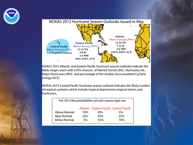
NOAA’s 2013 Atlantic Hurricane Season Outlook indicates that an above-normal season is most likely, with the possibility that the season could be
very active. The outlook calls for a 70% chance of an above-normal season, a 25% chance of a near-normal season, and only a 5% chance of a below-normal season.
See NOAA definitions of above-, near-, and below-normal seasons, which have been slightly modified from previous years. The
Atlantic hurricane region includes the North Atlantic Ocean, Caribbean Sea, and Gulf of Mexico.
The 2013 seasonal hurricane outlook reflects a combination of climate factors that have historically produced above-normal Atlantic hurricane seasons. The three main
climate factors for this outlook are:
1) The ongoing set of atmospheric conditions that have been producing increased Atlantic hurricane activity since 1995,
which includes
2) An expected continuation of above-average sea surface temperatures (SSTs) across the tropical Atlantic Ocean and Caribbean Sea, and
3) A likely continuation of ENSO-neutral conditions (i.e., no El Niño or La Niña); meaning El Niño is not expected to develop and suppress the
hurricane season.
This combination of climate factors historically produces above-normal Atlantic hurricane seasons. The 2013 hurricane season could see activity comparable to some of the
very active seasons since 1995.
Based on the current and expected conditions, combined with model forecasts, we estimate a 70% probability for
each of the following ranges of activity during 2013:
- 13-20 Named Storms
- 7-11 Hurricanes
- 3-6 Major Hurricanes
- Accumulated Cyclone Energy (ACE) range of 120%-205%
The seasonal activity is expected to fall within these ranges in 70% of seasons with similar climate conditions and uncertainties to those expected this year. These ranges
do not represent the total possible ranges of activity seen in past similar years.
Note that the expected ranges are centered well above the official NHC 1981-2010 seasonal averages of 12 named storms, 6 hurricanes, and 3 major hurricanes.
This Atlantic hurricane season outlook will be updated in early August, which coincides with the onset of the peak months of the hurricane season.
Hurricane Landfalls:
While NOAA does not make an official seasonal hurricane landfall outlook, the historical likelihood for multiple U.S. hurricane strikes, and for multiple hurricane strikes
in the region around the Caribbean Sea, increases sharply for very active (or hyperactive) seasons (ACE > 165% of median). It only takes one storm hitting an area to cause
a disaster, regardless of the overall activity predicted in the seasonal outlook. Therefore, residents, businesses, and government agencies of coastal and near-coastal
regions are urged to prepare every hurricane season regardless of this, or any other, seasonal outlook.
Predicting where and when hurricanes will strike is related to daily weather patterns, which are not reliably predictable weeks or months in advance. Therefore, it is
currently not possible to accurately predict the number or intensity of landfalling hurricanes at these extended ranges, or whether a particular locality will be impacted
by a hurricane this season.
DISCUSSION
1. Expected 2013 activity
Climate signals and evolving oceanic and atmospheric conditions, combined with dynamical and statistical model forecasts, indicate that an above normal Atlantic hurricane
season is likely in 2013. This outlook calls for a 70% chance of an above-normal season, a 25% chance of a near-normal season, and only a 5% chance of a below-normal
season. See NOAA definitions of above-, near-, and below-normal seasons, which have been slightly modified from previous
years.
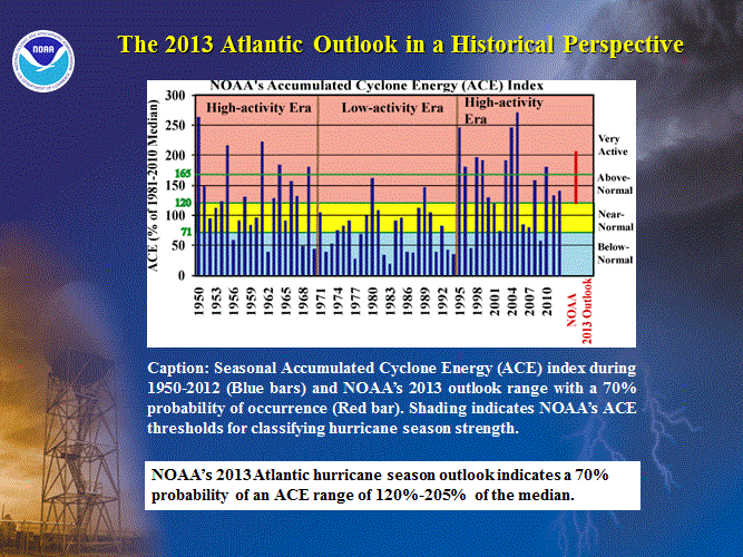
An important measure of the total overall seasonal activity is NOAA’s Accumulated Cyclone Energy (ACE) index, which accounts
for the intensity and duration of named storms and hurricanes during the season. This outlook indicates a 70% chance that the 2013 seasonal ACE range will be 120%-205% of
the median. According to NOAA’s hurricane season classifications, an ACE value above 120% of the 1981-2010 median reflects an
above-normal season, and an ACE value above 165% of the median reflects a very active (or hyperactive) season.
The 2013 Atlantic hurricane season is predicted to produce (with 70% probability for each range) 13-20 named storms, of which 7-11 are expected
to become hurricanes, and 3-6 are expected to become major hurricanes. These ranges are centered well above the 1981-2010 period averages of 12 named storms, 6 hurricanes
and 3 major hurricanes.
For the U.S. and the region around the Caribbean Sea, the historical probability of a hurricane strike generally increases with increasing seasonal activity. During very
active seasons, the historical probabilities increase markedly for multiple hurricane strikes in these regions. Nonetheless, predicting the location, number, timing, and
strength of hurricanes landfalls is ultimately related to the daily weather patterns, which are not predictable weeks or months in advance. As a result, it is currently
not possible to reliably predict the number or intensity of land-falling hurricanes at these extended ranges, or whether a given locality will be impacted by a hurricane
this season. Therefore, NOAA does not make an official seasonal hurricane landfall outlook.
2. Science behind the 2013 Outlook
The 2013 seasonal hurricane outlook reflects a combination of climate factors which have historically produced above-normal Atlantic hurricane activity. The three main
climate factors for this outlook are: 1) the tropical multi-decadal signal in the atmosphere, which reflects conditions associated with the
ongoing high-activity era that began in 1995 (Goldenberg et al. 2001, Bell and Chelliah 2006), 2) the expected continuation of above-average SSTs in
the Main Development Region (MDR), which spans the Caribbean Sea and tropical Atlantic Ocean between 9°N-21.5°N; Goldenberg et al. 2001),
and 3) ENSO-neutral conditions
most likely to persist in the tropical Pacific Ocean.
The outlook also takes into account dynamical model predictions from the NOAA Climate Forecast System (CFS), NOAA Geophysical Fluid Dynamics Lab (GFDL) model CM2.1, the
European Centre for Medium Range Weather Forecasting (ECMWF), the United Kingdom Meteorology (UKMET) office, the EUROpean Seasonal to Inter-annual Prediction (EUROSIP)
ensemble, along with ENSO (El Niño/ Southern Oscillation) forecast models contained in the suite of Niño 3.4 SST forecasts compiled by the
IRI (International Research Institute for Climate and Society) and the NOAA Climate Prediction Center.
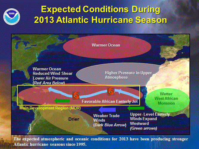
a. Expected continuation of tropical multi-decadal signal
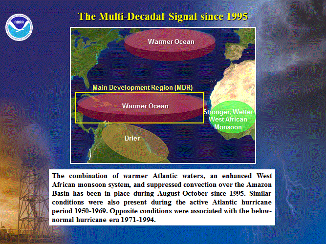
One factor guiding this outlook is the expected continuation of the tropical multi-decadal signal (Goldenberg et al. 2001, Bell and Chelliah 2006), which has contributed
to the current high-activity era in the Atlantic basin that began in 1995. This signal incorporates the warm phase of the Atlantic Multi-decadal
Oscillation (AMO) and an enhanced west African monsoon system. It is associated with an inter-related set of atmospheric conditions that are
conducive to increased Atlantic hurricane activity.
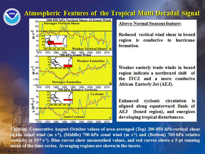
During 1995-2012, some key atmospheric aspects of the tropical multi-decadal signal have included reduced vertical wind shear and weaker easterly
trade winds, and a configuration of the African easterly jet (i.e. increased cyclonic shear) that is much more conducive to hurricane development from tropical cloud
systems (aka easterly waves) moving off the African coast.
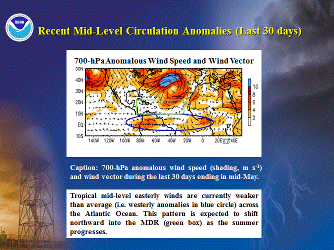
Two important features of the multi-decadal signal are now present: the warm phase of the AMO, and with weaker mid-level
easterly winds across the eastern tropical Pacific and tropical Atlantic Ocean. During ASO, this wind pattern typically produces a more conducive configuration of the
African easterly jet.
b. Expected above-average SSTs in the Main Development Region
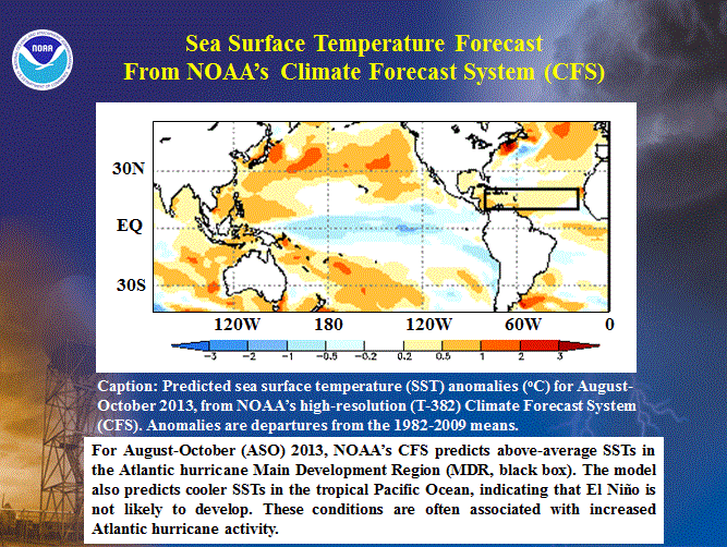
The second factor guiding this outlook is the expectation of above-average SSTs across the MDR during much of the hurricane season. This expectation is based on current
observations, the ongoing warm phase of the AMO, and CFS T-382 model forecasts.
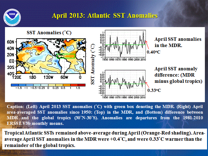
April sea surface temperatures measured over the entire MDR were 0.4oC above-average, and were also well above those of the remainder
of the global tropics. This relative warmth is consistent with the ongoing high-activity era, and with our expectation for an above-normal Atlantic hurricane season this
year.
c. ENSO-neutral conditions
Another climate factor known to significantly impact Atlantic hurricane activity is ENSO. The three phases of ENSO are El Niño, La Niña, and neutral. El Niño tends to
suppress Atlantic hurricane activity, while La Niña tends to enhance it (Gray 1984). These typical impacts can be strongly modulated by conditions associated with a
low- or high-activity hurricane era.
The combination of a high-activity era, above-average Atlantic SSTs, and ENSO-neutral historically produces active or very active Atlantic hurricane seasons. ENSO-neutral
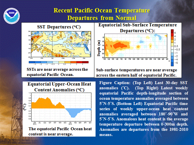
conditions have been present since last summer. Currently, equatorial Pacific SSTs are near average and the Niño 3.4 index is slightly below
zero. The equatorial Pacific sub-surface temperatures and oceanic heat content are also near average.
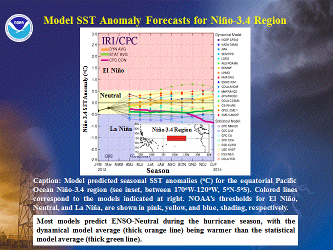
Most models contained in the suite of IRI/ CPC Niño 3.4 SST forecasts predict ENSO-neutral conditions for ASO, with the statistical forecasts
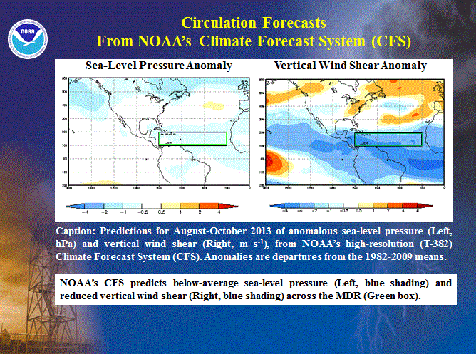
being generally cooler than the dynamical models. The CFS T-382 high-resolution model below-average SSTs in this region, which is consistent with
its forecast for below-average sea-level pressure and reduced vertical wind shear within the MDR. This CFS model is also
predicting above-average SSTs in the MDR during ASO.
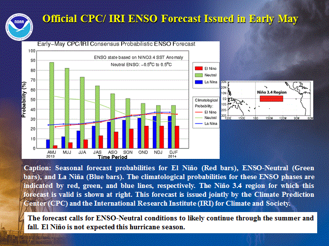
The observations, ENSO model forecasts, the official CPC/IRI ENSO forecast issued in early May, all suggest
that ENSO-neutral conditions are likely to continue through the summer and fall (55% chance). There is no substantial expectation that El Niño will develop this summer or
early fall and suppress the hurricane season.
3. Multi-decadal fluctuations in Atlantic hurricane activity
Atlantic hurricane seasons exhibit extended periods lasting decades (25-40 years) of generally above-normal or below-normal activity. These
multi-decadal fluctuations in hurricane activity result almost entirely from differences in the number of hurricanes and major hurricanes forming from tropical storms
that first develop in the MDR.
The current high-activity era began in 1995 (Goldenberg et al. 2001). Hurricane seasons during 1995-2012 have averaged about 15 named storms, 8 hurricanes, and 4 major hurricanes, with an ACE
index of 151% of the median. NOAA classifies 12 of the 18 seasons since 1995 as above normal, with eight being very active (i.e., hyperactive defined by ACE > 165% of
median). Only two seasons since 1995 were below normal (1997 and 2009).
This high level of activity contrasts sharply to the low-activity era of 1971-1994 (Goldenberg et al. 2001), which averaged only 8.5 named storms, 5 hurricanes, and
1.5 major hurricanes, with an ACE index of only 74% of the median. One-half of the seasons during this period were below normal, only two were above normal (1980, 1989),
and none were hyperactive.
Within the MDR, the atmospheric circulation anomalies that contribute to these long-period fluctuations in hurricane activity are strongly linked to
the Tropics-wide multi-decadal signal (Bell and Chelliah 2006), which incorporates the warm phase of the AMO and an enhanced west African
monsoon system. A change in the phase of the tropical multi-decadal signal coincides with the transition in 1995 from a low-activity era to the current high-activity era.
NOAA FORECASTERS
Climate Prediction Center
Dr. Gerry Bell, Lead Forecaster, Meteorologist; Gerry.Bell@noaa.gov
Dr. Jae Schemm, Meteorologist; Jae.Schemm@noaa.gov
National Hurricane Center
Eric Blake, Hurricane Specialist; Eric.S.Blake@noaa.gov
Todd Kimberlain, Hurricane Specialist; Todd Kimberlain@noaa.gov
Dr. Chris Landsea, Meteorologist; Chris.Landsea@noaa.gov
Dr. Richard Pasch, Hurricane Specialist; Richard.J.Pasch@noaa.gov
Hurricane Research Division
Stanley Goldenberg, Meteorologist; Stanley.Goldenberg@noaa.gov
REFERENCES
Bell, G. D., and M. Chelliah, 2006: Leading tropical modes associated with interannual and multi-decadal fluctuations in North Atlantic hurricane activity. J. of Climate. 19, 590-612.
Goldenberg, S. B., C. W. Landsea, A. M. Mestas-Nuñez, and W. M. Gray, 2001: The recent increase in Atlantic hurricane activity: Causes and implications. Science, 293, 474-479.
Gray, W. M., 1984: Atlantic seasonal hurricane frequency: Part I: El Niño and 30-mb quasi-bienniel oscillation influences. Mon. Wea. Rev., 112, 1649-1668.
Landsea,C.W., G.A. Vecchi, L. Bengtsson, and T. R. Knutson, 2010: Impact of duration thresholds on Atlantic tropical cyclone counts. J. Climate, 23, 2508-2519
|


