Although seasons with similar conditions to those now in place and seasons with similar early-season activity have generally been above-normal, they have featured a wide range of activity. Allowing for uncertainties, we estimate a 67% probability for each of the following seasonal (June-November) ranges, all of which are above average:
- 14-18 named storms,
- 7-10 Hurricanes
,
- 3-6 Major Hurricanes,
- An ACE range 140%-230% of the median
These likely seasonal ranges have been observed in about two-thirds (67%) of past seasons having similar climate conditions and similar early-season activity to this year. They do not encompass the total range of activity seen in those past seasons.
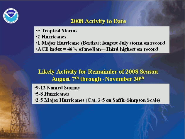
To date, the 2008 Atlantic hurricane season has produced five named storms, two hurricanes, and one major hurricane.
This means that we expect considerable activity during the remainder of the 2008 season, with an additional 9-13 named storms, 5-8 hurricanes and 2-5 major hurricanes likely during the remainder of the season (August 7th through November 30th).
DISCUSSION
1. Expected 2008 Activity
This Outlook is a general guide to the expected overall activity for the 2008 Atlantic hurricane season, and for the remainder (August-November) of the season. It is not a seasonal hurricane landfall forecast, and it does not imply levels of activity for any particular area.
The 2008 outlook largely reflects the historical distribution of activity for the dominant climate factors now present, as well as the historical distribution of activity for seasons having significant June-July activity. Two uncertainties in the outlook are the contribution from lingering La Niña impacts, and the possibility that other unpredictable factors could also influence the season.
As predicted in our May outlook, the atmospheric and oceanic conditions typically associated with an above-normal season are now in place, and are expected to produce considerable tropical storm and hurricane activity during the remainder of the 2008 season. These conditions are related to two main climate factors: 1) The multi-decadal signal, which has been conducive to above-normal Atlantic hurricane activity since 1995, and which includes above-normal Atlantic sea-surface temperatures, and 2) a lingering La Niña signal as reflected in Pacific Ocean temperatures, convection and winds.
Another factor guiding the outlook is the strong early-season activity over the tropical Atlantic. This activity is a good indicator of an above normal 2008 season.
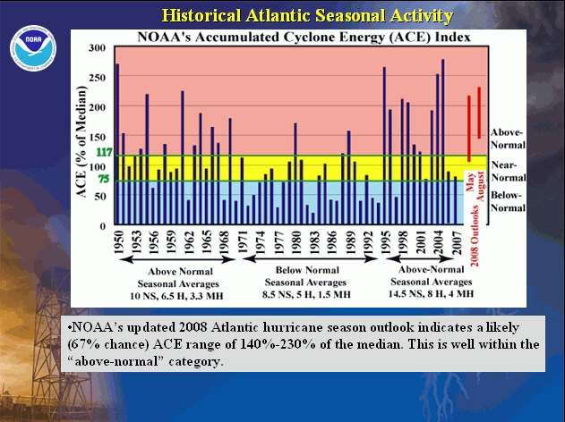
An important measure of the seasonal activity is NOAA’s Accumulated Cyclone Energy (ACE) index, which accounts for the collective intensity and duration of named storms and hurricanes during the season. The lower threshold of ACE for an above-normal season is 117% of the median. The outlook indicates a likely (67% chance) ACE range of between 140% and 230% of the median. The early-season activity has already produced an ACE value of 46% of the median.
The outlook calls for a 67% chance for each of the following seasonal ranges: 14-18 Named Storms, 7-10 Hurricanes, and 3-6 Major Hurricanes. All of these ranges are above the long-term averages of 11 named storms, six hurricanes, and two major hurricanes. Note that the predicted range for ACE can be satisfied even if these predicted numbers of named storms, hurricanes, and major hurricanes fall outside the likely ranges.
The 2008 hurricane season has already produced 5 named storms, two hurricanes, and one major hurricane. Therefore, for the remainder of the season (August 7th through November 30th), we expect (67% chance) an additional 9-13 Named Storms, 5-8 Hurricanes, and 2-5 Major Hurricanes.
Based on the ACE prediction, and on the expected above-average numbers of named storms, hurricanes, and major hurricanes, there is an 85% chance the 2008 season will be above normal.
Promising new climate models that predict seasonal tropical cyclone activity in the Atlantic are also suggesting an active season. These forecasts are consistent with our assessment of the current and evolving oceanic and atmospheric conditions for the 2008 Atlantic hurricane season.
2. Expected Climate Conditions – Active hurricane era, lingering La Niña impacts
a. Expected continuation of active Atlantic hurricane era
Atlantic hurricane seasons exhibit prolonged periods lasting decades of generally above-normal or below-normal activity. These fluctuations in hurricane activity result almost entirely from differences in the number of hurricanes and major hurricanes forming from tropical storms first named in the Main Development Region (MDR), which spans the tropical Atlantic Ocean and Caribbean Sea (Goldenberg et al. 2001).
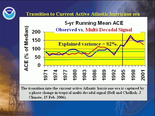
The current active hurricane era began in 1995. Hurricane seasons during 1995-2007 have averaged 14.5 named storms, 8 hurricanes, and 4 major hurricanes, with an average ACE index of 167% of the median. NOAA classifies nine of the thirteen seasons since 1995 as above normal, with seven being hyperactive (ACE > 175% of median). Only four seasons since 1995 have not been above normal. These include three El Niño years (1997, 2002, and 2006) and the 2007 season.
This high level of activity since 1995 contrasts sharply to the 1971-1994 period of generally below-normal hurricane seasons (Goldenberg et al. 2001), which averaged only 8.5 named storms, 5 hurricanes, and 1.5 major hurricanes with an average ACE index of only 75% of the median. One-half of those seasons were below normal, only three were above normal (1980, 1988, 1989), and none were hyperactive.
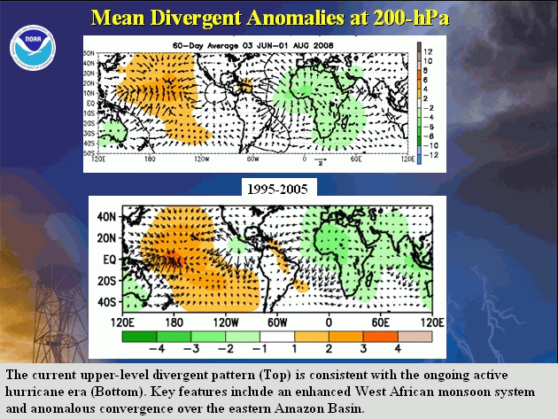
The regional atmospheric circulation anomalies that contribute to these long-period fluctuations in hurricane activity are strongly linked to the tropics-wide multi-decadal signal (Bell and Chelliah, 2006). A change in phase of the multi-decadal signal accounts for the transition in 1995 from the below-normal to the above normal era. The conditions associated with the multi-decadal signal are a major factor guiding the 2008 outlook. Three key features of this signal now in place include: 1) a stronger West African monsoon system, 2) below-average convection in the Amazon Basin, and 3) ongoing warmer than average Atlantic Ocean temperatures.
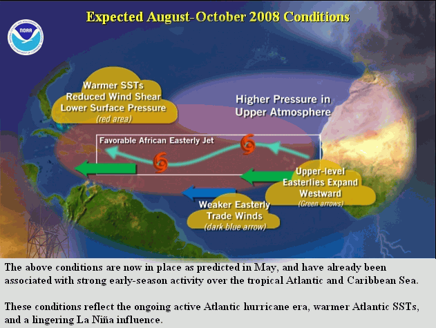
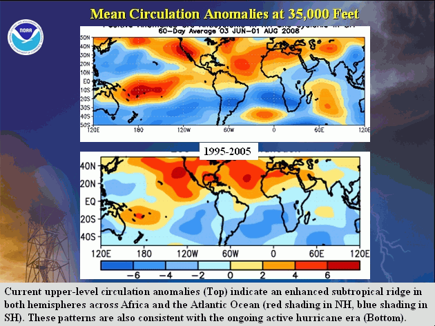
Other regional features of the multi-decadal signal currently affecting the Atlantic include 1) an amplified ridge at upper levels across the central and eastern subtropical North Atlantic, 2) reduced vertical wind shear in the deep tropics over the central North Atlantic, which results from an expanded area of easterly wind anomalies in the upper atmosphere (green arrows) and weaker easterly trade winds (westerly anomalies) in the lower atmosphere (dark blue arrows), and 3) weaker easterly winds also evident in the middle atmosphere near Africa, resulting in a configuration of the African easterly jet that favors hurricane development from tropical waves moving westward from the African coast. These conditions have already been responsible for the high levels of early season activity, and they are expected to persist through the season.
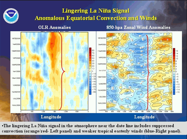
b. Lingering La Niña influence
In the latest ENSO Diagnostics Discussion released 7 August 2008, NOAA forecasters state that although La Niña has ended, lingering La Niña impacts are evident in the patterns of tropical convection and winds over the central and western Pacific. This evolution is consistent with NOAA predictions in May. As discussed by Gray (1984), La Niña conditions are typically associated with higher Atlantic hurricane activity, and El Niño with lower hurricane activity. The combination of lingering La Niña conditions and an active hurricane era increases the probability of an above-normal season.
c. Atlantic Sea-surface temperatures (SSTs)
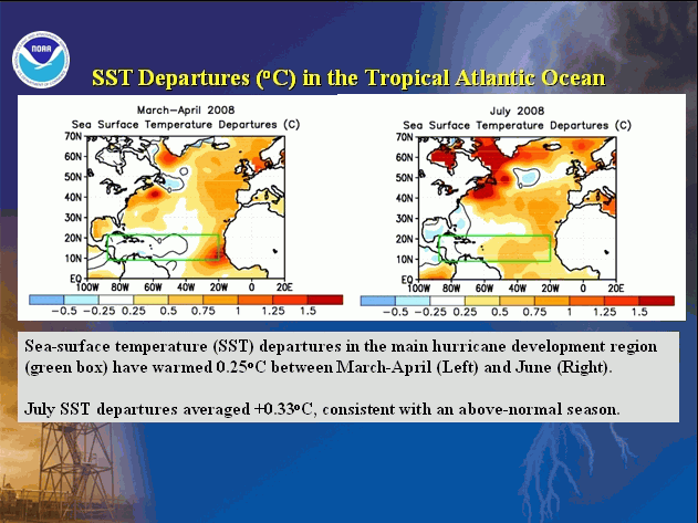
Above-average temperatures returned to the tropical Atlantic during the summer. For the entire main development region, sea-surface temperatures during July averaged +0.3°C, which is consistent with an above-normal season, the ongoing active hurricane era, and longer-term trends.
NOAA FORECASTERS
Climate Prediction Center
Dr. Gerry Bell, Meteorologist; Gerry.Bell@noaa.gov
Dr. Jae Schemm, Meteorologist; Jae.Schemm@noaa.gov
Dr. Tingzhuang Yan, Meteorologist; Tingzhuang.Yan@noaa.gov
National Hurricane Center
Eric Blake, Hurricane Specialist; Eric.S.Blake@noaa.gov
Todd Kimberlain, Meteorologist; Todd Kimberlain@noaa.gov
Dr. Chris Landsea, Meteorologist; Chris.Landsea@noaa.gov
Dr. Richard Pasch, Hurricane Specialist; Richard.J.Pasch@noaa.gov
Hurricane Research Division
Stanley Goldenberg, Meteorologist; Stanley.Goldenberg@noaa.gov
REFERENCES
Bell, G. D., and M. Chelliah, 2006: Leading tropical modes associated with interannual and multi-decadal fluctuations in North Atlantic hurricane activity. J. Climate. 19, 590-612.
Bell, G. D., and Co-authors 2007: The 2006 Atlantic Hurricane Season: A Climate Perspective. State of the Climate in 2006. A. M. Waple and J. H. Lawrimore, Eds. Bull. Amer. Meteor. Soc., 88, S1-S78.
Bell, G. D., and Co-authors 2008: The 2007 Atlantic Hurricane Season: A Climate Perspective. State of the Climate in 2007. A. M. Waple and J. H. Lawrimore, Eds. Bull. Amer. Meteor. Soc., 89, S1-S78.
Goldenberg, S. B., C. W. Landsea, A. M. Mestas-Nuñez, and W. M. Gray, 2001: The recent increase in Atlantic hurricane activity: Causes and implications. Science, 293, 474-479.
Gray, W. M., 1984: Atlantic seasonal hurricane frequency: Part I: El Niño and 30-mb quasi-bienniel oscillation influences. Mon. Wea. Rev., 112, 1649-1668.


