| SUMMARY
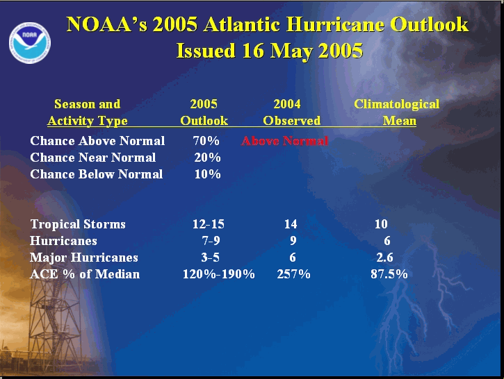
NOAA’s 2005 Atlantic hurricane season outlook indicates a 70% chance of an above-normal hurricane season, a 20% chance of a near-normal season, and only a 10% chance of a below-normal season. This outlook is produced by scientists at the National Oceanic and Atmospheric Administration's (NOAA) Climate Prediction Center (CPC), Hurricane Research Division (HRD), and National Hurricane Center (NHC). See NOAA’s definitions of above-, near-, and below-normal seasons.
The outlook calls for 12-15 tropical storms, with 7-9 becoming hurricanes, and 3-5 of these becoming major hurricanes. The likely range of ACE index is 120%-190% of the median. This prediction reflects a very likely continuation of above-normal activity that began in 1995.
The predicted 2005 activity reflects 1) an expected continuation of conditions associated with the tropics-wide multi-decadal signal, which has favored above-normal Atlantic hurricane seasons since 1995, and 2) an expected continuation of warmer sea surface temperatures in the tropical Atlantic Ocean than can be accounted for by the multi-decadal signal alone. The outlook also reflects the expectation of ENSO-neutral conditions (no El Niño or La Niña) during August-October, the peak months of the hurricane season. An updated Atlantic hurricane outlook will be issued in early August.
DISCUSSION
1. Expected Activity- 70% chance above normal, 20% chance near normal, 10% chance below normal
An important measure of the total seasonal activity is NOAA’s Accumulated Cyclone Energy (ACE) index, which accounts for the collective intensity and duration of Atlantic tropical storms and hurricanes during a given hurricane season. The ACE index is also used to define above-, near-, and below-normal hurricane seasons (see Background Information). A value of 117% of the median (Median value is 87.5) corresponds to the lower boundary for an above-normal season.
For the 2005 Atlantic hurricane season the ACE index is expected to be in the range of 120%-190% of the median. The outlook also calls for 12-15 tropical storms, with 7-9 becoming hurricanes, and 3-5 of these becoming major hurricanes [categories 3-4-5 on the Saffir-Simpson scale]. While it is reasonable to expect this range of tropical storms and hurricanes, the total seasonal activity measured by the ACE index can certainly be in the predicted range without all three of these criteria being met.
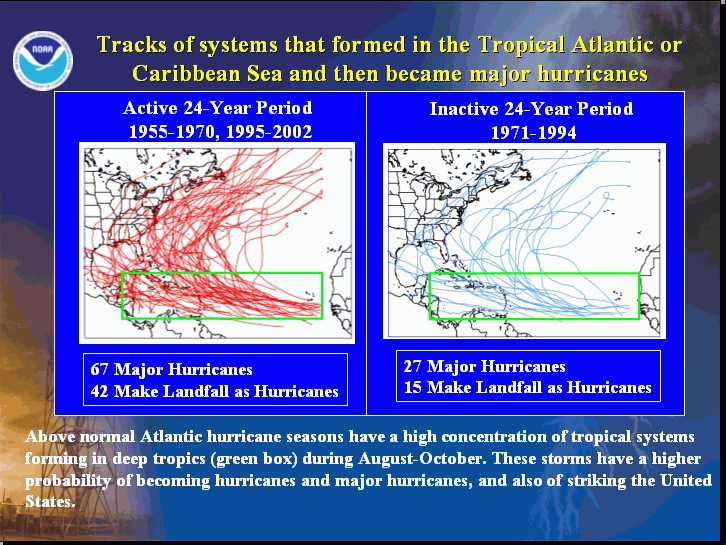
The vast majority of the tropical storms and hurricanes in 2005 will form during August-October. Many of these are likely to form over the tropical Atlantic and Caribbean Sea in the region between 9°N-21.5°N (green box), which is typical for above-normal seasons. These systems generally track westward toward the Caribbean Sea and/or United States as they strengthen. Historically, similar seasons have averaged 2-3 landfalling hurricanes in the continental United States and 1-2 hurricanes in the region around the Caribbean Sea. However, it is currently not possible to confidently predict at these extended ranges the number or intensity of landfalling hurricanes, and whether or not a given locality will be impacted by a hurricane this season.
2. Expected Climate Conditions – Active multi-decadal signal, above-average Atlantic Ocean temperatures, ENSO-neutral conditions
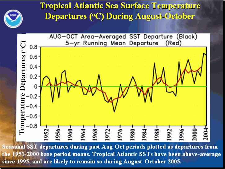
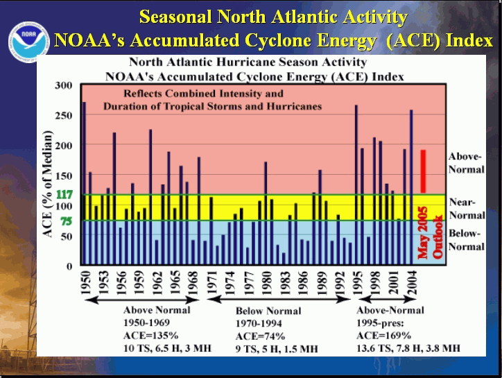
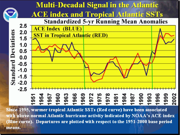
Beginning with 1995 all of the Atlantic hurricane seasons have been above normal, with the exception of two El Niño years (1997 and 2002). This contrasts sharply with the generally below-normal activity observed during the previous 25-year period 1970-1994 (Goldenberg et al. 2001, Science). Time series of key atmospheric wind parameters and Atlantic SSTs highlight the dramatic differences between these above-normal and below-normal periods. Conditions were also very conducive above-normal hurricane seasons during the 1950s and 1960s, as seen by comparing Atlantic SSTs and seasonal ACE values.
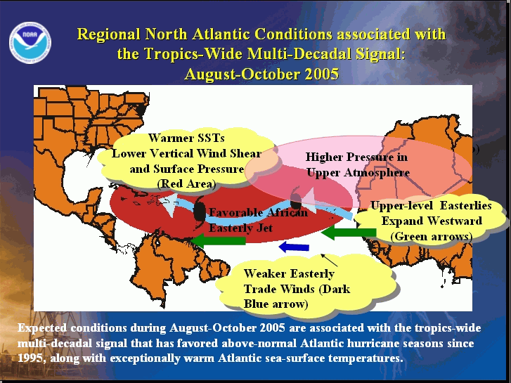
The regional atmospheric circulation features and oceanic conditions causing these very long-period fluctuations in hurricane activity are linked to the tropics-wide multi-decadal signal (Bell and Chelliah, Journal of Climate 2005). This multi-decadal signal has been very conducive to above-normal hurricane seasons since 1995, and is again a main factor guiding the 2005 outlook.
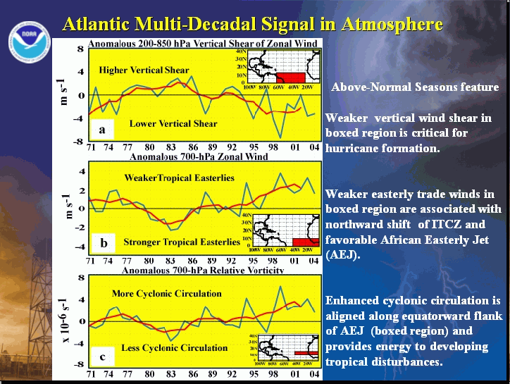
Over the North Atlantic, key aspects of the multi-decadal signal expected during the 2005 hurricane season include 1) lower surface air pressure, warmer SSTs, and increased moisture across the central and eastern tropical Atlantic, 2) an amplified subtropical ridge at upper levels across the central and eastern North Atlantic, 3) reduced vertical wind shear in the deep tropics over the central North Atlantic, which results from an expanded area of easterly winds in the upper atmosphere (green arrows) and weaker easterly trade winds in the lower atmosphere (dark blue arrows), and 4) a configuration of the African easterly jet (wavy light blue arrow) that favors hurricane development from tropical disturbances moving westward from the African coast.
Also expected this season is a continuation of tropical Atlantic SSTs that are warmer than can be accounted for by the multi-decadal signal. This additional warmth is more conducive to hurricane formation than would be expected from the multi-decadal signal alone.
Another factor known to significantly impact Atlantic hurricane seasons is ENSO (Gray 1984, Monthly Weather Review), with El Niño favoring fewer hurricanes and La Niña favoring more hurricanes. Based on the most recent ENSO outlook issued by NOAA’s Climate Prediction Center, ENSO-neutral conditions are expected in the tropical Pacific through at least the first half of the hurricane season. Therefore, the ENSO phenomenon is not expected to impact this hurricane season.
3. Multi-decadal fluctuations in Atlantic hurricane activity
Atlantic hurricane seasons exhibit prolonged periods lasting decades of generally above-normal or below-normal activity. These multi-decadal fluctuations in hurricane activity result nearly entirely from differences in the number of hurricanes and major hurricanes forming from tropical storms first named in the tropical Atlantic and Caribbean Sea.
Hurricane seasons during 1995-2004 have averaged 13.6 tropical storms, 7.8 hurricanes, 3.8 major hurricanes, and with an average ACE index of 159% of the median. NOAA classifies all but two of these ten seasons (El Niño years of 1997 and 2002) as above normal. In contrast, during the preceding 1970-1994 period, hurricane seasons averaged 9 tropical storms, 5 hurricanes, and 1.5 major hurricanes, with an average ACE index of only 75% of the median. NOAA classifies twelve (almost one-half) of these 25 seasons as being below normal, and only three as being above normal (1980, 1988, 1989).
4. Uncertainties in the Outlook
The main uncertainty in this outlook is not whether the season will be above normal, but how much above normal it will be. There is the possibility of another extremely active season similar to that seen in 2003 and 2004, when seasonal ACE values were 200% and 257% of the median, respectively. These very active seasons resulted partly from the combination of near-record warmth across the tropical Atlantic and an amplified upper-level ridge over the western subtropical North Atlantic and eastern United States (Bell et al. 2004, 2005 Bulletin of the American Meteorological Society). In the event that the subtropical ridge is again enhanced in these regions, which is not predictable at this time, the 2005 seasonal ACE value could exceed the high end of our predicted range.
A second uncertainty is that weak El Niño conditions may occur during August-October, as indicated by some ENSO forecasts. Although unlikely, El Niño conditions during this period could reduce the chance for an above-normal season.
NOAA scientists will closely monitor the evolving climate conditions. A more confident El Nino forecast will be available for NOAA’s updated Atlantic hurricane outlook to be issued in early August, which is prior to the normal active portion of the Atlantic hurricane season.
CAUTIONARY NOTES
1) It is important to recognize that it is currently not possible to confidently predict at these extended ranges the number or intensity of landfalling hurricanes, or whether a particular locality will be impacted by a hurricane this season. Therefore, residents and government agencies of coastal and near-coastal regions should always maintain hurricane preparedness efforts regardless of the overall seasonal outlook.
2) Far more damage can be done by one major hurricane hitting a heavily populated area than by several hurricanes hitting sparsely populated areas or, of course, not making landfall at all. Therefore, hurricane-spawned disasters can occur even in years with near-normal or below-normal levels of activity. Examples of years with near-normal activity that featured extensive hurricane damage and numerous fatalities include 1960 (Hurricane Donna), 1979 (Hurricanes David and Frederic), and 1985 (Hurricanes Elena, Gloria and Juan). Moreover, the nation's most damaging hurricane, Andrew in 1992, occurred during a season with otherwise below normal activity.
FORECASTERS
NOAA's Climate Prediction Center
Dr. Gerald Bell, Meteorologist; Gerry.Bell@noaa.gov
Dr. Muthuvel Chelliah, Physical Scientist; Muthuvel.Chelliah@noaa.gov
Dr. Kingste Mo, Meteorologist; Kingste.Mo@noaa.gov
NOAA's Hurricane Research Division
Stanley Goldenberg, Meteorologist; Stanley.Goldenberg@noaa.gov
Dr. Christopher Landsea, Meteorologist; Chris.Landsea@noaa.gov
NOAA's National Hurricane Center
Eric Blake, Meteorologist; Eric.S.Blake@noaa.gov
Dr. Richard Pasch, Meteorologist; Richard.J.Pasch@noaa.gov
|


