| SUMMARY
NOAA is calling for a 95% to 100% chance of an above-normal 2005 Atlantic hurricane season, according to a consensus of scientists at National Oceanic and Atmospheric Administration's (NOAA) Climate Prediction Center (CPC), Hurricane Research Division (HRD), and National Hurricane Center (NHC). This forecast reflects NOAA’s highest confidence of an above-normal hurricane season since their outlooks began in August 1998.
The updated outlook calls for an extremely active season, with an expected seasonal total of 18-21 tropical storms (mean is 10), with 9-11 becoming hurricanes (mean is 6), and 5-7 of these becoming major hurricanes (mean is 2-3). The likely range of the ACE index for the season as a whole is 180%-270% of the median.
The predicted seasonal totals include the considerable activity that has already occurred prior to this update (7 tropical storms and 2 major hurricanes). Therefore, for the remainder of the season, we expect an additional 11-14 tropical storms, with 7-9 becoming hurricanes, and 3-5 of these becoming major hurricanes. The expected ACE range during August-November is 110%-200% of the median. These very high levels of activity are comparable to those seen during August-November 2003 and 2004. Given the forecast that the remainder of the season will be very active, it is imperative that residents and government officials in hurricane-vulnerable communities have a hurricane preparedness plan in place.
The predicted nearly 100% chance of an above-normal season is higher than the 70% likelihood indicated in NOAA’s pre-season outlook issued May 16th. This increased certainty reflects the fact that the atmospheric and oceanic conditions favoring hurricane formation that were predicted in May are now in place. These conditions, combined with the high levels of activity already seen, make an above-normal season nearly certain.
DISCUSSION
1. Expected Activity- 95%-100% chance of above normal
The atmospheric and oceanic conditions favoring hurricane formation that were predicted in May are now in place. These conditions, combined with the high levels of activity already seen, make an above-normal season nearly certain (95% to 100%). There is only a 0%-5% chance of a near-normal season, and a 0% chance of a below-normal season. (see Background Information for NOAA’s definitions of above-, near-, and below-normal seasons)
An important measure of the total seasonal activity is NOAA’s Accumulated Cyclone Energy (ACE) index, which accounts for the collective intensity and duration of Atlantic tropical storms and hurricanes during a given hurricane season. The ACE index is also used to define above-, near-, and below-normal hurricane seasons. A value of 117% of the median (Median value is 87.5) corresponds to the lower boundary for an above-normal season.
For the 2005 Atlantic hurricane season the outlook calls for an extremely active season, with the seasonal ACE index forecasted to range from 180%-270% of the median. This range is above the 175% baseline that Goldenberg et al. (Science, 2001) use to define a hyperactive season. The outlook also calls for a seasonal total of 18-21 tropical storms, with 9-11 becoming hurricanes, and 5-7 of these becoming major hurricanes [categories 3-4-5 on the Saffir-Simpson scale]. Because the ACE index does not directly account for the numbers of tropical storms, hurricanes, and major hurricanes, the predicted ACE range can verify even if these numbers fall outside their predicted ranges.
This forecast reflects NOAA’s highest confidence of an above-normal hurricane season since their outlooks began in August 1998. This prediction also reflects a continuation of above-normal activity that began in 1995, and will likely be the seventh extremely active season since 1995.
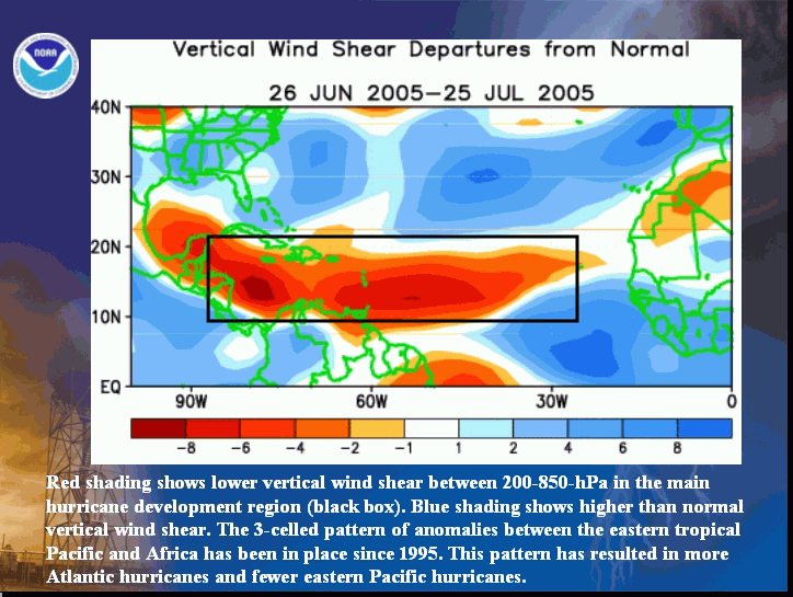
Even though there has already been considerable early season activity (7 tropical storms, with two becoming major hurricanes), most of the activity is still expected to occur during the climatological peak months of August-October. Many of the storms during this period will develop from disturbances moving westward from the west coast of Africa, and will likely form over the tropical Atlantic Ocean and Caribbean Sea in the region between 9°N-21.5°N (black box). Historically, tropical storms that first form in these areas account for 55% of all hurricanes and 80% of all major hurricanes. They also account for nearly the entire difference in hurricanes and major hurricanes between above-normal and below-normal hurricane seasons.
Tropical storms that form over the tropical Atlantic Ocean generally track westward toward the Caribbean Islands and/or United States as they strengthen into hurricanes, and therefore pose an increased threat to these regions. Historically, seasons with above-normal levels of overall activity have averaged 2-3 U.S. hurricane landfalls and 1-2 landfalls in the region around the Caribbean Sea during August-November.
Although the conditions that produce hurricane landfalls are well known, they are often related to the daily weather patterns rather than the seasonal climate patterns, and are very difficult to predict at these extended ranges. As a result, it is currently not possible to confidently predict the number or intensity of landfalling hurricanes at these extended ranges, or whether a given locality will be impacted by a hurricane this season. Nonetheless, given the forecast of above-normal activity for the remainder of the season, it is imperative that residents and government officials in hurricane-vulnerable communities have a hurricane preparedness plan in place.
2. Expected Climate Conditions – Active multi-decadal signal, above-average Atlantic Ocean temperatures, exceptionally favorable wind and air pressure patterns
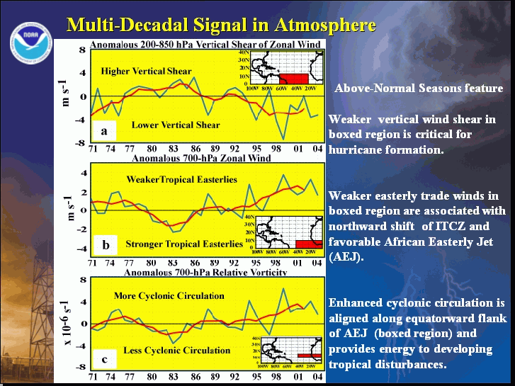
Beginning with 1995 all of the Atlantic hurricane seasons have been above normal, with the exception of two El Niño years (1997 and 2002). This contrasts sharply with the generally below-normal activity observed during the previous 25-year period 1970-1994 (Goldenberg et al. 2001, Science). Time series of key atmospheric wind parameters and Atlantic SSTs highlight the dramatic differences between these above-normal and below-normal periods. Conditions were also very conducive for above-normal hurricane seasons during the 1950s and 1960s, as seen by comparing Atlantic SSTs and seasonal ACE values.
The regional atmospheric circulation features and oceanic conditions causing these very long-period fluctuations in hurricane activity are linked to the tropics-wide multi-decadal signal (Bell and Chelliah 2005, Journal of Climate). This multi-decadal signal has been very conducive to above-normal hurricane seasons since 1995, and is the main contributing factor to the above-normal 2005 activity.
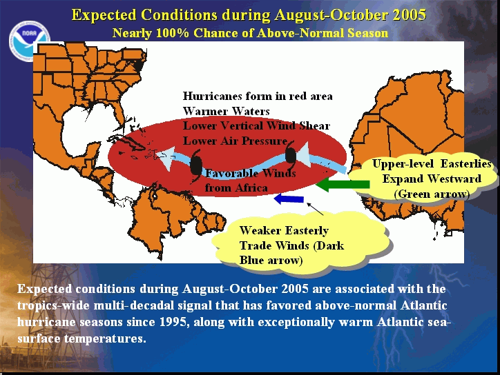
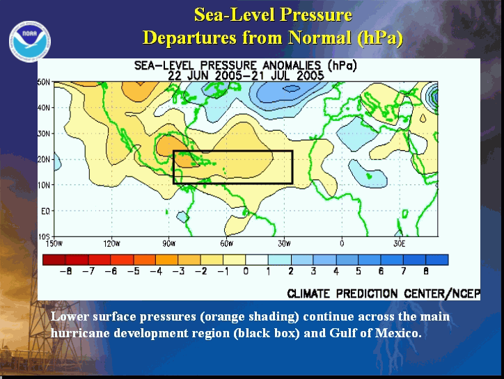
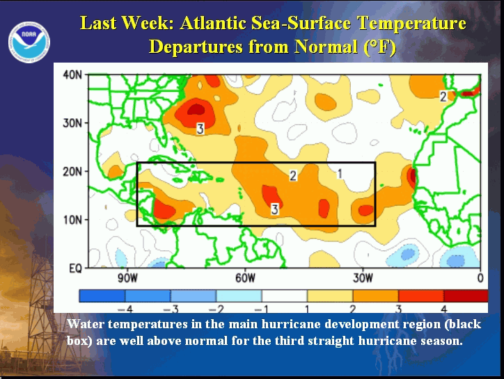
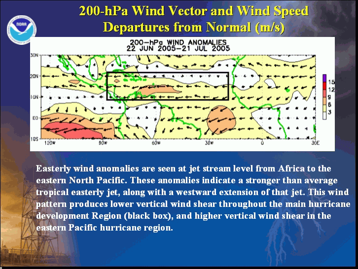
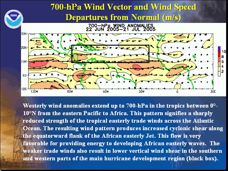
The favorable conditions predicted by NOAA in their outlook issued May 16th are now in place. These conditions are expected to persist through the peak August-October months of the season. They include 1) lower surface air pressure and exceptionally warm SSTs across the tropical Atlantic and Caribbean Sea, 2) an amplified subtropical ridge at upper levels across the central and eastern North Atlantic, 3) reduced vertical wind shear over the tropical North Atlantic and Caribbean Sea, which results from an expanded area of easterly winds in the upper atmosphere and weaker easterly trade winds in the lower atmosphere, and 4) a configuration of the African easterly jet (wavy light blue arrow) that favors hurricane development from tropical disturbances moving westward from the African coast.
Of particular relevance to this outlook is that two July tropical systems, Major Hurricanes Dennis and Emily, formed over the eastern Caribbean Sea and over the central tropical Atlantic (near 10°N), respectively. It is rare for hurricanes to develop in these regions during July because the wind patterns are normally so unfavorable. The formation of Major Hurricanes Dennis and Emily in these regions is another indication that favorable conditions are already in place for a very active season.
Another factor known to significantly impact Atlantic hurricane seasons is ENSO (Gray 1984, Monthly Weather Review), with El Niño events favoring fewer hurricanes and La Niña events favoring more hurricanes. Based on the most recent ENSO outlook issued by NOAA’s Climate Prediction Center, ENSO-neutral conditions are expected in the tropical Pacific through October. Therefore, the ENSO phenomenon is not expected to impact this hurricane season.
3. Multi-decadal fluctuations in Atlantic hurricane activity
Historically, Atlantic hurricane activity has exhibited very strong multi-decadal variability, with alternating periods lasting several decades of generally above-normal or below-normal activity. These multi-decadal fluctuations in hurricane activity result nearly entirely from differences in the number of hurricanes and major hurricanes forming from tropical storms first named in the tropical Atlantic and Caribbean Sea.
Hurricane seasons during 1995-2004 have averaged 13.6 tropical storms, 7.8 hurricanes, 3.8 major hurricanes, and with an average ACE index of 159% of the median. NOAA classifies all but two of these ten seasons (El Niño years of 1997 and 2002) as above normal, and six of these years as hyperactive. If the 2005 season verifies as predicted, it will be the seventh hyperactive season in the last 11 years. In contrast, during the preceding 1970-1994 period, hurricane seasons averaged 9 tropical storms, 5 hurricanes, and 1.5 major hurricanes, with an average ACE index of only 75% of the median. NOAA classifies twelve (almost one-half) of these 25 seasons as being below normal, only three as being above normal (1980, 1988, 1988), and none as being hyperactive.
4. Uncertainties in the Outlook
The main uncertainty in this outlook is the number of landfalling tropical storms and hurricanes in the United States and the region around the Caribbean Sea. Although the conditions that produce hurricane landfalls are well known, they are very difficult to predict at these extended ranges because they are often related to the daily weather patterns rather than the seasonal climate patterns. It is currently not possible to confidently predict the number or intensity of landfalling hurricanes at these extended ranges, or whether a given locality will be impacted by a hurricane this season. Historically, seasons with above-normal levels of overall activity have averaged 2-3 U.S. hurricane landfalls and 1-2 landfalls in the region around the Caribbean Sea during August-November. Given the forecast of above-normal activity for the remainder of the season, it is imperative that residents and government officials in hurricane-vulnerable communities have a hurricane preparedness plan in place.
FORECASTERS
NOAA's Climate Prediction Center
Dr. Gerald Bell, Meteorologist; Gerry.Bell@noaa.gov
Dr. Muthuvel Chelliah, Physical Scientist; Muthuvel.Chelliah@noaa.gov
Dr. Kingste Mo, Meteorologist; Kingste.Mo@noaa.gov
NOAA's Hurricane Research Division
Stanley Goldenberg, Meteorologist; Stanley.Goldenberg@noaa.gov
Dr. Christopher Landsea, Meteorologist; Chris.Landsea@noaa.gov
NOAA's National Hurricane Center
Eric Blake, Meteorologist; Eric.S.Blake@noaa.gov
Dr. Richard Pasch, Meteorologist; Richard.J.Pasch@noaa.gov
|


