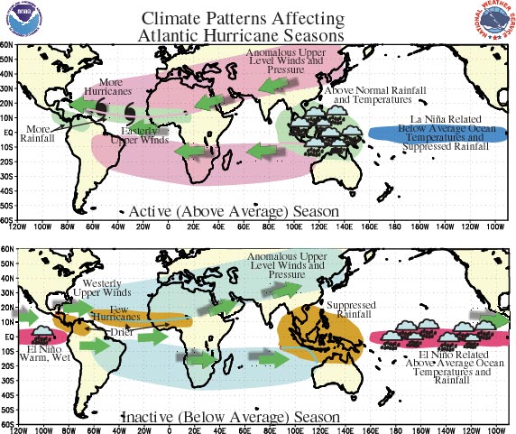
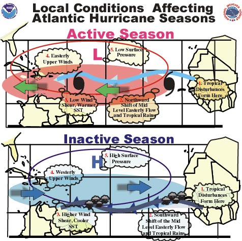
1. The current global-scale atmospheric circulation pattern is
conducive to an above-average (active) Atlantic hurricane season during 2000, by favoring reduced vertical wind shear across the western tropical Atlantic and
Caribbean Sea, and easterly winds from Africa that are conducive to the development of
tropical storms and hurricanes.
2. Historically, when similar atmospheric conditions were present in an active
hurricane era, 75% of the Atlantic hurricane seasons featured above-average activity.
3. The continuation of the current atmospheric anomalies depends partly on the ongoing
La Niña in the tropical Pacific. A consensus of the latest numerical and statistical
model forecasts indicate a continuation of La Niña conditions at least through July.
Thereafter, the forecasts tend to diverge, but a majority indicate either near-normal or
weak La Niña conditions continuing to the end of the year. However, we expect that even
if La Niña fades by late summer, the existing tropical rainfall anomalies will not be
totally destroyed, and therefore will not unduly impact the favorable large-scale
atmospheric circulation pattern that currently exists. Another contribution to conditions
favorable for an active season comes from the above-average sea surface temperatures that
have persisted since 1995 across large portions of the North Atlantic.
4. Typical features of active (above-average) hurricane years:
Most of the above-average activity will occur during the peak months of the season:
August– October.
The season often features at least two of the following three: a) at least eleven
tropical storms, b) seven or more of which become hurricanes, and c) three or more of
which become major hurricanes.
Overall activity is very high. Overall activity includes measures of storm duration and
intensity, as well as storm numbers, hurricane numbers, etc.
Many of the storms are expected to develop over the tropical Atlantic, and then move
westward toward the Caribbean Islands or the United States, thereby putting coastal areas
at an increased risk of experiencing a tropical storm or hurricane. In active years the
Caribbean Islands and the United States each experience an average of 2-3 hurricane
strikes. For the Caribbean Islands, this frequency of hurricane landfall is much larger
than that which is observed in inactive years.
Additional discussion
Background
Information
CAUTIONARY NOTES
1) This Outlook should be used as a guide of overall expected activity for the Atlantic
basin. No outlook can give certainty as to whether a particular locality will be impacted
by a tropical storm or hurricane in any given year. Residents and government agencies of
coastal or near_coastal regions should always maintain hurricane preparedness efforts
regardless of the overall outlook for a given year.
2) Far more damage can be done by one major hurricane hitting a heavily populated area
than by several major hurricanes hitting sparsely populated areas or, of course, not
making landfall at all. Because of this, hurricane spawned disasters can occur even in
relatively inactive years. Also, increased activity in a given year does not automatically
mean increased storm-related damage.
3) Although major hurricanes tend to be the deadliest and costliest tropical systems,
disasters can and indeed do occur due to flooding from less intense hurricanes and
tropical storms.
4) Our expectation of above-average activity during 2000 is not based on global warming
associated with elevated carbon dioxide levels.
ACKNOWLEDGEMENTS
This outlook is not designed to compete with hurricane outlooks issued by groups
outside of NOAA. We gratefully acknowledge the pioneering research of Dr. William Gray and
others, which has significantly increased scientific understanding of the association
between the various climate factors (particularly the El Niño/ La Niña cycle) and the
atmospheric circulation features that affect Atlantic basin hurricane activity. We also
acknowledge the leading role that Dr. Gray and colleagues at the Colorado State University
have played in developing and providing seasonal forecasts of Atlantic basin tropical
storm and hurricane activity.
CONTACTS
Dr. Lixion Avila, Meteorologist, National Hurricane Center; ph: 305-229-4470; lixion@nhc.noaa.gov
Dr. Gerald Bell, Meteorologist, Climate Prediction Center: ph: 301-763-8000 x 7536; gbell@ncep.noaa.gov
Dr. Muthuvel Chelliah, Physical Scientist, Climate Prediction Center: ph: 301-763-8000
x 7546; mchelliah@ncep.noaa.gov
Mr. Stanley Goldenberg, Meteorologist, Hurricane Research Division: ph: 305-361-4362;goldenberg@aoml.noaa.gov
Dr. Christopher Landsea, Meteorologist, Hurricane Research Division: ph: 305-361-4357; landsea@aoml.noaa.gov
Dr. Richard Pasch, Meteorologist, National Hurricane Center; ph: 305-229-4411; richard@nhc.noaa.gov


