|
Latest Seasonal Assessment -
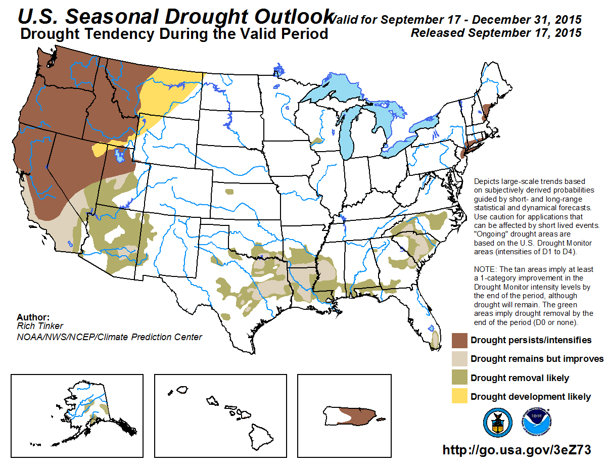
Since the previous seasonal outlook release on August 20, conditions deteriorated substantially from central and northeastern Texas eastward through the lower Mississippi Valley. Record and near-record late summer dryness was observed at a few locations, and accumulated deficits over the last 75 days exceeded 4 inches across much of the region. A few spots in northern Louisiana and east-central Texas had drought intensities go from D0 (abnormally dry) to D3 (extreme drought) during the past month. Heavy rain (6 to 10 inches in the last 30 days) was confined to the Texas and Louisiana Gulf Coast region, where dryness generally eased.
The southwestern monsoon resulted in scattered areas of above-normal rainfall during the past 30 days, while seasonal dryness prevailed elsewhere across the remainder of the interior West. Drought maintained its intensity across most of the region, with abnormally hot weather contributing to some deterioration in the northern Intermountain West, while locally heavy rain prompted improvement in parts of western Washington, southeastern Arizona, and southwestern New Mexico. Scattered heavy rain and flash flooding affected a few spots in the West in mid-September. Los Angeles, CA recorded over an inch of rain on September 15, which almost equaled their normal for the 6-month May - October period. A few inches of rain fell quickly in northern and southern Utah, causing excessive runoff and deadly flash. However, these isolated extreme events did not affect the longer-term dryness and drought that covers the region. Away from Los Angeles, wildfires spread quickly and consumed homes in a few locations, most notable the mountains outside San Francisco, CA.
A broken pattern of abnormal dryness was observed in the central Plains, the Upper Peninsula of Michigan, the Ohio Valley, the mid-Atlantic, and the Northeast, reflected by areas of new D0 conditions during the last couple of weeks. There was also a slight expansion of the moderate drought in and around the New York City area. Meanwhile, dryness and drought improved in the upper Midwest, parts of the Southeast, and southern Florida. Heavy rain has soaked the Florida Panhandle and the adjacent south Atlantic and northeastern Gulf Coasts. 30-day totals of 6 to 10 inches were common, with isolated sites receiving almost 15 inches, prompting the improvement in south Florida.
Unseasonably heavy rain continued to pelt much of Hawaii, where widespread improvement has been observed. From mid-August to mid-September, both Honolulu and Lihue received over 10 inches of rain, compared to normal of just 0.5 inch and 1.08 inches, respectively. Both Alaska and Puerto Rico experienced regional relief from moderate rainfall, with a significant decrease in drought coverage across central and southeastern Alaska.
With the strong El Niño event underway and expected to continue through the forecast period, our Outlook is based primarily on conditions typically observed during these events, with some consideration for longer-term trends and model output, all of which is reflected in the October -November-December 3-Month Outlooks. Impacts on the drought include likely persistence for the small areas in the Northeast and the broad area of drought in the northwest and much of California, with some development expected in concert with the favored dryness in the northern Rockies. Along the central and southern California coast, and in a broad swath from the Southwest to the Southeast, abundant precipitation, especially later in the period, is expected to bring widespread improvement. As this is a relatively dry time of year, drought is most likely to persist where it exists in Puerto Rico and Hawaii while additional slow relief is expected in Alaska.
|
|
Tools used in the U.S. Seasonal Drought Outlook (SDO) included the official Climate Prediction Center (CPC) temperature and precipitation outlooks for October 2015 and October - December (OND) 2015, various short- and medium-range forecasts and models such as the 5-day and 7-day precipitation totals forecast (QPFs) from the Weather Prediction Center (WPC), the 6-10 day and 8-14 day CPC extended-range forecasts (ERFs), the NAEFS precipitation outlooks, the soil moisture tools based on the Constructed Analog on Soil Moisture (CAS), dynamical models (CFSv2, NMME, IRI, IMME, and ECMWF), the 384-hour total precipitation forecasts from several runs of the GFS, the four-month Palmer drought termination and amelioration probabilities, October - December climatology for each month and the season as a whole, and initial conditions. An El Niño (ENSO) Advisory remains in effect, with the September 10, 2015 ENSO Diagnostic Discussion indicating a 95 percent chance of El Niño conditions continuing through Northern Hemisphere winter 2015-16. Collectively, current oceanic and atmospheric conditions reflected a strong El Niño, according to the Diagnostic Discussion, and strong El Niño conditions are expected to continue for at least the next few months. In fact, for this time of year, most indicators classify the current El Niño as one of the 3 to 5 strongest on record (since 1950). Currently, the effects of El Niño on conditions in the United States are minimal, which is expected at this time of year; however, it will become increasingly influential as fall progresses into winter. Given the strength of the event, and the fact that the atmosphere is already responding where expected, El Niño correlations dominated forecast considerations, along with initial conditions. The official Long Lead Forecasts similarly gave a lot of weight to El Niño considerations.
The areas of moderate drought along the Northeast coast should continue through the end of December. Strong El Niño episodes generally bring drier than normal weather to the Northeast during the last 3 months of the year, although the correlation is not strong. Still, with no heavy precipitation (thus no improvement) expected during the last half of September, drought is expected to persist.
Forecast confidence in the Northeast is low.
In the Southeast, the Florida Peninsula is expecting heavy precipitation over the next 5 to 7 days, with central and southern parts anticipating 1.5 to 3.5 inches. Rainfall should be unremarkable in the rest of the region through the last half of September, but El Niño strongly favors above-normal precipitation throughout the region for the rest of the forecast period.. The October - December Precipitation Outlook favors above-normal amounts throughout the region, especially Peninsular Florida.
Forecast confidence for Southeast is high.
The small area of drought in southwestern Wisconsin should get a bit over an inch of precipitation in the next 7 days, with dry weather favored for the last week of September. Over the ensuing 3 months, the October - December Precipitation Outlook favors neither unusually dry nor unusually wet conditions, and strong El Niño episodes very slightly favor wet weather more than dry; Given it is also getting colder, it seems more likely than not that this area of moderate drought will be removed by the end of September.
Forecast confidence in southwest Wisconsin is low.
In the central and southern Great Plains and the lower Mississippi Valley, up to 2 inches of rain may fall on Oklahoma in the next week, but in general, precipitation through the end of September is expected to be near or below normal. El Niño episodes strongly correlate to abnormally wet conditions during October - December, and the official 3-month Outlook reflects this. Consequently, it seems unlikely that drought will persist unchanged until the end of the year, thus improvement or removal is anticipated.
Forecast confidence in the Plains and lower Mississippi Valley is high.
From the northern Rockies through the Pacific Northwest and southward into northern California, the next week is expected to be generally dry except for some moderate precipitation in westernmost Washington. The odds for above-normal precipitation increase during the last week of September, but El Niño favors below-normal precipitation across this region during the ensuing 3 months as the climatological wet season gets underway. Any surplus precipitation in the next few weeks is expected to be overwhelmed by drier than normal weather thereafter, resulting in a forecast of persistence. In addition, drought is expected to expand into the region from northeast Nevada through adjacent Idaho, northwestern Wyoming, and much of Montana, where El Niño and the October - December Outlook also favor unusually dry conditions the last quarter of the year
Forecast confidence from the northern Rockies to the Pacific Northwest and northern California is high.
El Niño conditions strongly favor above-normal precipitation across Arizona, southern Nevada, and the southern half of Utah, as does the October - December Outlook. There is some indication that late September will be wetter than normal as well. Thus improvement is expected by the end of the year.
Forecast confidence in Arizona, southern Nevada, and the southern half of Utah is high.
Heavy precipitation is also significantly favored across southern California as the wet season gets underway. Drought conditions are not as serious in southeastern California as they are in most of the rest of the state, so with indicators strongly pointing toward enhanced precipitation during October - December, improvement and/or removal is expected there. Coastal southern California is experiencing extreme drought, but the expected wetness should be enough to bring at least limited improvement by the end of the year. Los Angeles, CA recorded more rain on September 15 (1.8 inches) than is normal during the entire dry half of the year (May - October). All signs point toward improvement, although a little less enthusiastically near the coast.
Forecast confidence in southern California is high.
Central California and western Nevada is a tricky forecast. Although the official October - December Outlook is non-committal, strong El Niño episodes tend to bring heavy precipitation farther north than lesser events do, and the stronger the episode, the better the chance for enhanced October - December precipitation. On the other hand, antecedent conditions feature an entrenched drought that has deepened over the course of 4 years, and one or even a few heavy precipitation events may not be enough to substantially change things early in the wet season. The odds seem best for some improvement along the immediate coast, where precipitation increases most readily in response to stronger El Niño episodes, and where precipitation is climatologically heavier. Farther east, from the interior valley of central California into west-central Nevada, the drought is exceptional and well-entrenched, and considering only the last one-half to one-third of the period is part of the typical wet season, precipitation would have to be markedly enhanced to bring any significant improvement, so persistence is forecast there.
Forecast confidence in central California and west-central Nevada is moderate.
Both Puerto Rico and Hawaii are entering their dry seasons as the year winds down, reducing the odds for drought-changing amounts of precipitation, even considering El Niño tends to favor above-normal dry-season rainfall in Puerto Rico. Drought persistence is favored.
Forecast confidence in both Hawaii and Puerto Rico is moderate.
Drought has improved significantly with soaking rains affecting the Alaska Panhandle. Moderate drought areas farther to the north, across central and interior southeast Alaska, have not been as wet and have responded more slowly, but a continuation of gradual improvement is expected.
Forecast confidence in Alaska is moderate.
|


