|
Latest Seasonal Assessment -
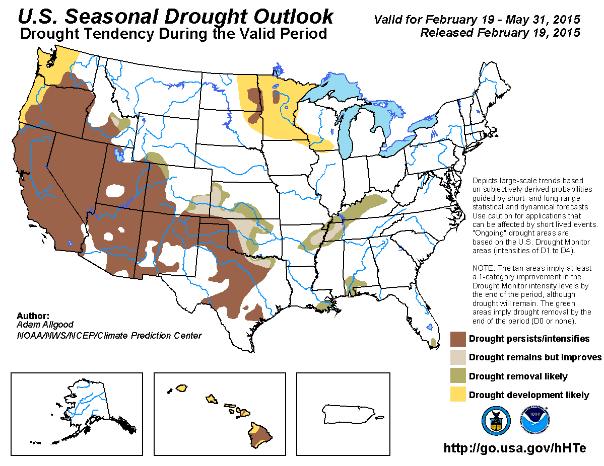
A plume of subtropical moisture brought much needed rainfall to parts of northern California, coastal Oregon, and Washington during early February, generating modest
drought reductions. The storms were the first to impact California since mid-December. Above-normal temperatures prevented any significant snowpack building, however,
and snow water equivalent values across the Cascades and Sierra Nevadas remained well below average. Rainfall was also observed across southern Arizona, much of New
Mexico, and western Texas, bringing localized drought improvements, although snow levels remain well below normal in these regions as well. In contrast, dry weather
promoted drought expansion from the lower Mississippi Valley through the southern Ohio Valley, the upper Midwest, and far southern Florida. Much below normal temperatures
overspread the northeastern CONUS, with heavy snowfall from multiple storm systems blanketing much of New England.
Precipitation climatology begins decreasing considerably during March across the West, and additional snowpack building becomes less likely during the transition into
Spring. Mostly dry weather is forecast for the upcoming week across the West, with several dynamical models favoring a transition to a wetter pattern during early March.
The CPC monthly and seasonal outlooks both tilt the odds towards below median precipitation from northern California northward, and it is unlikely that any precipitation
falling during March would have a significant impact on drought conditions through May, especially given the much below normal snowpack conditions. Therefore, drought
persistence is forecast for the West, with additional development possible across the Pacific Northwest. Although the CPC monthly and seasonal outlooks favor above-median
precipitation across the Four Corners states, drought persistence is anticipated due to much below normal mountain snowpack conditions, low reservoir levels, and a
relatively dry Spring climatology. In contrast, some drought improvements are possible across the north-central Rockies where current snowpack levels are near or above
normal, and where May is a climatologically wetter month. Precipitation increases substantially across the central Plains during May, and with no tilt in the odds towards
above or below median rainfall, some improvements to drought conditions are anticipated for southeastern Colorado, Kansas, and central Oklahoma. The prospects for
significant drought reductions are less across western Oklahoma, most of Texas and eastern New Mexico, where long-term drought is entrenched and climatological late Spring
rainfall is less likely to bring large scale improvements. Below normal snow coverage following a dry Fall season makes drought persistence and development more likely
across much of the upper Midwest, while a robust late February storm system is forecast to bring several inches of rainfall across the lower Mississippi Valley, Tennessee
Valley, and Ohio Valley, which is anticipated to improve drought conditions. A tilt in the odds towards above median precipitation across the Southeast favors
improvements along the Gulf Coast and the Everglades, while drought conditions are anticipated to expand across Hawaii.
|
|
Tools used in the U.S. Seasonal Drought Outlook (SDO) included the official Climate Prediction Center (CPC) temperature and precipitation outlooks for
March 2015 and March-May 2015, various short- and medium-range forecasts and models such as the 5-day and 7-day precipitation totals forecast (QPFs) from the
Weather Prediction Center (WPC), the 6-10 day and 8-14 day CPC extended-range forecasts (ERFs), the
NAEFS precipitation outlooks, the soil moisture tools based
on the Constructed Analog on Soil Moisture (CAS), dynamical models (CFSv2, NMME, IRI, IMME, and ECMWF), the 384-hour total precipitation forecasts from several runs
of the GFS, the four-month Palmer drought termination and amelioration probabilities, Mar and Mar-May climatology, and initial conditions. An El Niño (ENSO) Watch is
still in effect, with the February 5 ENSO Diagnostic Discussion indicating a 50-60 percent chance of El Niño conditions through early spring, with ENSO-neutral
slightly favored thereafter.
A series of early February storm systems brought 1-Category drought improvements to parts of northern California, southwestern Oregon, and western Washington, while
below normal precipitation persisted across central and southern California, where drought is more entrenched. As of February 18, total SNOTEL Water Year
precipitation values were near normal across Washington, Oregon, and far northern California. Snowpack conditions in the same regions are very poor, however, with
snow water content values generally below 25 percent of normal across the Cascades and less than half of normal across the central Sierras. The lack of mountain snow
cover is due to persistent above normal temperatures across the region during the winter months, which has caused much of the precipitation observed to fall as rain.
The below normal snow cover presents a concern going into the Spring months, where reservoir recharge is partly dependent on snow melt. Precipitation climatology
decreases rapidly during March across the West, and the dry season is in full swing by May. Climatology, therefore, presents little opportunity for any significant
recharge. Mostly dry conditions and above normal temperatures are forecast during the upcoming 7 days. During Week-2, a pattern shift is anticipated as ridging over
the western CONUS retrogrades towards the Aleutians, allowing for a potential for increased precipitation and colder temperatures across the West during early March.
CFS precipitation forecasts maintain the highest probabilities for above-median precipitation across Northern California, Oregon, and Washington, while the ECMWF
forecast brings more precipitation over southern California. The CPC March and March-May outlooks indicate enhanced chances for below-median precipitation across the
northern and central Pacific Coast. Based on initial conditions and the longer term outlooks therefore, the potential for additional precipitation in early March is
not anticipated to provide any significant or lasting drought relief. Drought persistence or intensification is forecast for the Western states, with a potential for
additional drought development across the Northwest during the spring due to the below normal mountain snow coverage.
Forecast confidence for the West is high for persistence areas and moderate for additional drought expansion across the Northwest.
During the previous month, areas of above-normal rainfall boosted short term moisture levels and eased drought conditions across parts of Arizona and southwestern
New Mexico. In contrast, drought expanded across central New Mexico. As noted in the forecast discussion for the West above, above normal temperatures caused most
of this precipitation to fall as rain, which causes the resulting moisture increases to be shorter lived. Snow water content values at the higher elevations are
well below normal across the Southwest, ranging from below 25 percent of normal across central Arizona to 50-75 percent of normal across central New Mexico. Reservoir
levels are already below normal for this time of year, and the lack of snow cover may act to exacerbate this problem during the spring months. Both the CPC 1-month
and 3-month outlooks tilt the odds towards above-median precipitation across the Four Corners states, while the temperature outlooks indicate enhanced chances for
above-median temperatures across Arizona. Based on the initial conditions including low reservoir levels and below normal mountain snow coverage and a relatively dry
climatology, drought persistence is forecast for the existing drought areas across Utah, Arizona, New Mexico, and southwestern Utah. Although there is a potential for
additional drought development in areas that continue to receive little to no precipitation, no development areas were included on this map due to the long range
outlooks favoring above-median precipitation.
Forecast confidence for the Four Corners region is low.
Moderate to severe drought conditions continued across parts of southern Idaho, southwestern Wyoming, and western Colorado. Basin snow water content values are
generally near to above normal across the central and northern Rockies, including central Colorado, Wyoming, central Idaho, and western Montana. The CPC 3-month
outlook tilts the odds towards above-median precipitation across the central Rockies, including Colorado, southern Montana, and southeastern Idaho. Additionally, the
spring months are a generally wet time of year across the northern Rockies and adjacent Plains. Based on the CPC seasonal outlooks, climatology, and more favorable
initial conditions, therefore, drought improvement or removal is forecast for parts of central Idaho, southern Wyoming, and parts of northern Colorado.
Forecast confidence for the north-central Rockies is moderate.
Long-term drought conditions persisted across much of the south-central Plains, including areas of extreme to exceptional drought across southwestern Oklahoma and
northern Texas. Abnormal dryness and moderate drought conditions expanded eastward across the south-central Plains during the past month. Although the winter season
is mostly dry across the Plains, climatological precipitation increases substantially during the spring months, particularly across Kansas and Oklahoma as Gulf
moisture penetrates further north and west. The CPC 1-month and 3-month outlooks maintain equal chances for below, near, or above-median precipitation. Therefore,
the primary question for this outlook is whether climatological precipitation through May would be sufficient to ameliorate extant drought conditions. NCDC-based
drought amelioration probabilities are generally favorable for drought reduction; however, drought conditions, particularly in western Oklahoma and northern Texas
have been entrenched for several years. Therefore, without a clear signal for above-median precipitation, significant drought improvements are less certain. Therefore,
drought persistence is maintained for the longer term drought areas of northern Texas, eastern New Mexico, and western Oklahoma, while drought improvement is
indicated for northeastern Texas, central and eastern Oklahoma, and southeastern Colorado.
Forecast confidence for the south-central Plains is low to moderate.
Although 14-day percent of normal precipitation values are above normal across North Dakota and northern Minnesota, climatological precipitation is very low this
time of year. During the winter months, soil moisture and streams are frozen across the upper Midwest, making drought assessments more difficult. 6-month percent
of normal precipitation analyses spanning back to August 2014, however, indicate a region of below normal precipitation across the eastern Dakotas, much of Minnesota,
and southern Wisconsin. Additionally, snow water content is currently below normal over much of the upper Midwest, which, unless additional snowpack building occurs,
will result in reduced soil moisture recharge during the Spring melt. Light precipitation amounts (generally under 0.25 inch liquid equivalent) are forecast to
accumulate during the upcoming 7-day period, and the CPC 6-10 and 8-14 day outlooks favor below-median precipitation into early March. CPC Weeks 3 and 4 tools are
mixed, with the CFS favoring below normal precipitation and the ECMWF favoring above. Climatological precipitation increases during May across the upper Midwest. The
CPC 1-month and 3-month outlooks maintain equal chances for below, near, or above median precipitation during the period. In contrast, the CFS indicates a substantial
dry trend through the end of the Spring season. Based on the dry Fall conditions, current snow cover concerns, and a lack of a wet signal during the Spring,
persistence of current drought areas over the eastern Dakotas and north-central Minnesota are anticipated. Additional drought development is favored over portions of
the upper Midwest that are abnormally dry, including more of the eastern Dakotas, much of Minnesota, and southern Wisconsin.
Forecast confidence for the upper Midwest is moderate.
Below normal precipitation promoted drought expansion across eastern Arkansas, western Tennessee, and much of Kentucky during the previous month. During mid-February,
a potent winter storm moved through the Tennessee and Ohio Valleys, bringing significant icing to parts of Tennessee and over a foot of snow to parts of central
Kentucky. Additional storminess is forecast during the upcoming week, with widespread 7-day QPF totals from WPC topping 2-inches over most of the extant drought
areas. Cold, dry conditions are anticipated during the 6-10 day period, with a potential return to wetter conditions later in the Week-2 period. The CFS and ECMWF
favor a continuation of near to above normal precipitation during the Weeks 3 and 4 period. CPC's 1-month outlook tilts the odds towards above-median precipitation as
well. Based on the short term forecasts for heavy precipitation and the potential for wet conditions to continue during March, drought improvement or removal is
forecast for Arkansas, western Tennessee, and Kentucky.
Forecast confidence for Arkansas, western Tennessee, and Kentucky is moderate.
Small drought areas have developed over parts of the Southeastern coastal areas, including southern Louisiana, southern Alabama and the far western Florida Panhandle,
and the Florida Everglades. The CPC 1 and 3 month outlooks both tilt the odds towards above-median precipitation across the Southeast. Additionally, the South Florida
rainy season begins during late May. Based on these outlooks, drought improvement is forecast.
Forecast confidence for the east-central Gulf Coast and the Florida Everglades is moderate.
Abnormal dryness and moderate drought have expanded across Hawaii due to below-normal winter precipitation. The CPC 1-month outlook tilts the odds towards
below-median precipitation, and a continued expansion of drought is anticipated.
Forecast confidence for Hawaii is moderate.
|


