|
Latest Seasonal Assessment -
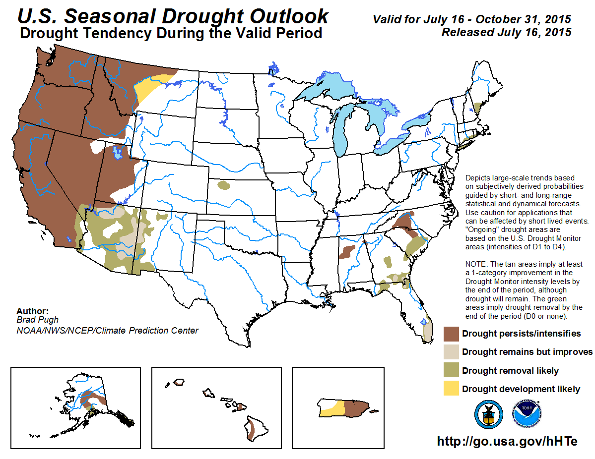
Since the previous seasonal outlook release on June 18, drought improvement occurred across the Northeast, Great Plains, and Four Corners region. Drought expanded across
the Southeast, while record heat and dry weather led to rapid intensification of drought across the Pacific Northwest, Idaho, and Montana. Drought recently developed
across parts of Alaska after a relatively dry, warm spring and early summer, and drought continued across the eastern half of Puerto Rico.
The drought outlook valid from July 16, 2015 through the end of October 2015 is based primarily on initial conditions, the CPC August-September-October (ASO) precipitation
outlook, climatology, and El Niño composites. Although drought improvement is expected across parts of the Southwest due to increased chances of enhanced monsoon rainfall,
long-term hydrological drought is likely to continue. Since ASO is a dry time of year, persistence is likely for most of California. Persistence and intensification of
drought (due to increased chances of above-normal temperatures this summer) is expected across the Pacific Northwest eastward to Montana. Due to the recent heat and
dryness, central Montana is primed for additional drought expansion.
Much of the central and eastern U.S. is drought-free and chances for drought development across the central/eastern Corn Belt are low due to a wet start to the summer.
Elimination of the residual drought areas across northwest Kansas, Long Island, and New England is expected during the outlook period. A relatively wet time of year favors
drought improvement/removal across southern Florida and the Southeast coastal Plain, while prospects for drought amelioration diminish across more inland areas of the
Southeast.
Drought is expected to persist across interior Alaska, while chances for drought removal are higher closer to the coast of south-central Alaska and the Alaska Panhandle.
The small areas of moderate drought are expected to persist across parts of the Hawaiian Islands with sufficient rainfall limited to the windward, east-facing slopes.
Suppressed convection, including a reduction of tropical cyclone activity across the Caribbean region is typical during El Niño summers. Therefore, drought persistence is
the most likely outcome across Puerto Rico.
|
|
Tools used in the U.S. Seasonal Drought Outlook (SDO) included the official Climate Prediction Center (CPC) temperature and precipitation outlooks for
August 2015 and August-September-October (ASO) 2015, various short- and medium-range forecasts and models such
as the 5-day and 7-day precipitation totals forecast (QPFs) from the Weather Prediction Center (WPC), the 6-10 day and
8-14 day CPC extended-range forecasts (ERFs), the NAEFS precipitation outlooks, the soil moisture tools based
on the Constructed Analog on Soil Moisture (CAS), dynamical models (CFSv2, NMME, IRI, IMME, and ECMWF), the 384-hour total precipitation forecasts from several runs
of the GFS, the four-month Palmer drought termination and amelioration probabilities, August and ASO climatology, and initial conditions. An El Niño (ENSO) Advisory
continues in effect, with the July 9, 2015 ENSO Diagnostic Discussion indicating a 90 percent chance of El Niño conditions continuing through Northern Hemisphere
winter 2015-16.
Improvement or removal of drought across the desert Southwest and New Mexico is based on short-term precipitation forecasts, increased chances for above-median
precipitation in CPC's August and ASO outlooks, and climatology. As of July 15, Hurricane Delores is located south of the Baja Peninsula. Delores is projected to
track west of the Baja Peninsula and likely result in a surge of moisture north along the Gulf of California. Therefore, locally heavy rainfall is expected during
the next week across the desert Southwest. The active East Pacific hurricane season is expected to continue due to the ongoing El Niño with the potential for
additional Gulf surges during the outlook period. Increased chances for above-median rainfall are forecast during a climatologically wet time of year. Typically, 30
to 45 percent of the annual precipitation occurs from August to October across the monsoon region of the Southwest. Despite the relatively strong wet signal among
the precipitation tools, forecast confidence is reduced due to the longevity of the drought. An increase in reservoir levels across the Southwest is not expected
until an adequate winter snowfall season occurs. Although the CPC ASO outlook favors above-median precipitation across the Great Basin, persistence is the most
likely outcome in this region as the next three months are not a relatively wet time of year.
Forecast confidence for the Southwest and Great Basin is low.
August to October is a dry time of year across California which strongly favors drought persistence for much of the State. Any drought removal, associated with
monsoon rainfall and tropical cyclone activity across the East Pacific, is expected to be limited to the southeast California desert.
Forecast confidence for California is high.
During the past three months, drought expanded or intensified across the Pacific Northwest and Idaho. Washington State observed its hottest and third driest June on
record. A dry climatology favors persistence, while enhanced odds for above-normal temperatures forecast during ASO could result in further intensification of
drought. Montana was drought-free as recently as early April. However, moderate to extreme drought rapidly developed due to a lack of precipitation (90-day deficits
of 4 inches or more) and above-normal temperatures (90-day departures of around +3 degrees F) during the past three months. Although precipitation signals are
rather weak among tools, the dry initial conditions and increased chances for above-normal temperatures during ASO favor persistence and development across Montana.
Forecast confidence for persistence/intensification across the Pacific Northwest, Idaho, and Montana is high and moderate for development across Montana.
A small area of moderate drought exists across northwest Kansas. Short-term rainfall along with increased chances for above-median precipitation in the
monthly/seasonal outlooks favors elimination of this small residual drought area.
Forecast confidence for northwest Kansas is moderate.
The U.S. Drought Monitor continues to depict long-term drought across parts of New England and Long Island. During the past month, much of New England has
experienced drought improvement and/or removal. These recent changes and short-term rainfall are expected to favor additional drought removal across New England and
Long Island.
Forecast confidence for New England and Long Island is moderate.
A lack of late spring/early summer rainfall coupled with above-normal temperatures resulted in short-term drought development across parts of Alabama, Georgia, the
Carolinas, and north Florida. A cold front is expected to focus convection with potentially heavy rainfall this week across southern Georgia and northern Florida.
Prospects for drought removal/improvement are higher across the coastal Plain of the Southeast and northern Florida where rainfall is typically higher during the
remainder of July and August. Forecast confidence for drought removal/improvement is limited due to the high evapotranspiration rates and high water demand during
the summer. It should be noted that October is typically a drier time of year which decreases chances of drought removal/improvement beyond September. Persistence is
favored for the Piedmont areas of the Southeast, but forecast confidence is low due to weak and conflicting precipitation signals among the tools.
Forecast confidence is low to moderate across the Southeast.
Seabreeze convection this summer has generally been focused across interior areas of the central and southern Florida peninsula. Precipitation deficits continue to
increase across the Atlantic coastal areas of southern Florida. As of July 15, the precipitation deficit is nearly 8 inches below-normal since June 1. Although there
is a tilt in the odds towards below-median precipitation among the seasonal tools, a very wet climatology favors drought improvement across southern Florida.
Forecast confidence is low for southern Florida.
A lack of snowfall this past winter, a relatively dry spring, and continued above-normal temperatures resulted in drought development across parts of Alaska since
the previous outlook. In addition to the drought concerns, the wildfire season is on a record pace. According to the Alaska Interagency Coordination Center, the
number of acres burned during 2015 is more than two weeks ahead of 2004, the worst year on record. Drought persistence is favored across interior Alaska due to the
initial conditions. Prospects for drought amelioration are higher for the Alaska Panhandle and Kenai Peninsula as temperatures cool during September and October and
frequency of fall storms increases.
Forecast confidence is low for Alaska.
For Hawaii, there is a tendency toward wetter conditions during El Niño summers, but trade winds occurring about 90 percent of the time favor the windward
(generally east-facing) slopes of the Islands receiving sufficient rainfall. Therefore, the small moderate drought areas are forecast to persist.
Forecast confidence in Hawaii is low.
Suppressed convection across much of Puerto Rico has resulted in rapidly deteriorating conditions. As of July 15, San Juan has recorded around 40 percent of its
normal rainfall since May 1, with a deficit of more than 10 inches. Dating back to 1898, this is the third driest period since May 1. Climate anomalies associated
with El Niño strongly favor suppressed convection and reduced tropical cyclone activity across the Caribbean, and this signal is supported by seasonal dynamical
model guidance. Therefore, drought is expected to persist or develop across much of Puerto Rico. However, the wet climatology during ASO may provide short-term
relief such as an increase in soil moisture.
Forecast confidence in Puerto Rico is low.
|


